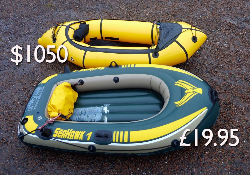
Remember Slackrafts? Around 2011 that was my made-up word from for cheap, vinyl, ultra-low-psi pooltoys using the same technology as children’s paddling pools. At the time they were some 3000% cheaper than the then dominant US-made TPU Alpackas (left), while looking vaguely similar to the paddle curious adventurer. For that price you really did wonder could there be so much difference? Experimentation proved the answer proved to be yes: a good TPU packraft is 3001% more enjoyable to paddle and 3002% more durable than a vinyl PoS.
Skinned SeaHawk results in minimal freeboard (Clashnessie)
Just before the subsequent Chinese-made packraft onslaught which must have just about peaked by now, Slackrafts was a dirt cheap way of trying ‘packrafting’ without the expense, responsive performance or durability. All you had to do was keep the thing from puncturing or bursting long enough to make up you mind. That might take a few hours or a few of days, especially once you cut off the outer chamber to make a slimmer, less bin-bag like raft (left) which retained adequate buoyancy for lighter paddlers. A decade or more ago various chums and I experimented with Slackrafts locally as well as in France, Scotland and remote northwest Australia, chartering a light plane to the headwaters of the Fitzroy, Australia’s longest river.
Fast forward to 2025 and YT algos led me to a bunch of Parkouriste youtubers called Storror with no less than 11m followers. In 2024 they set off in a boat-train of Intex and BestWay slackrafts for a paddle-less drift along the swiftly flowing Canal de la Toba, a hillside waterway of viaducts and spooky tunnels paralleling the Rio Jucar in Cuenca. The Toba starts near the town of Uña, midway between Madrid and Valencia, providing a reliable feed for a power station down the valley.
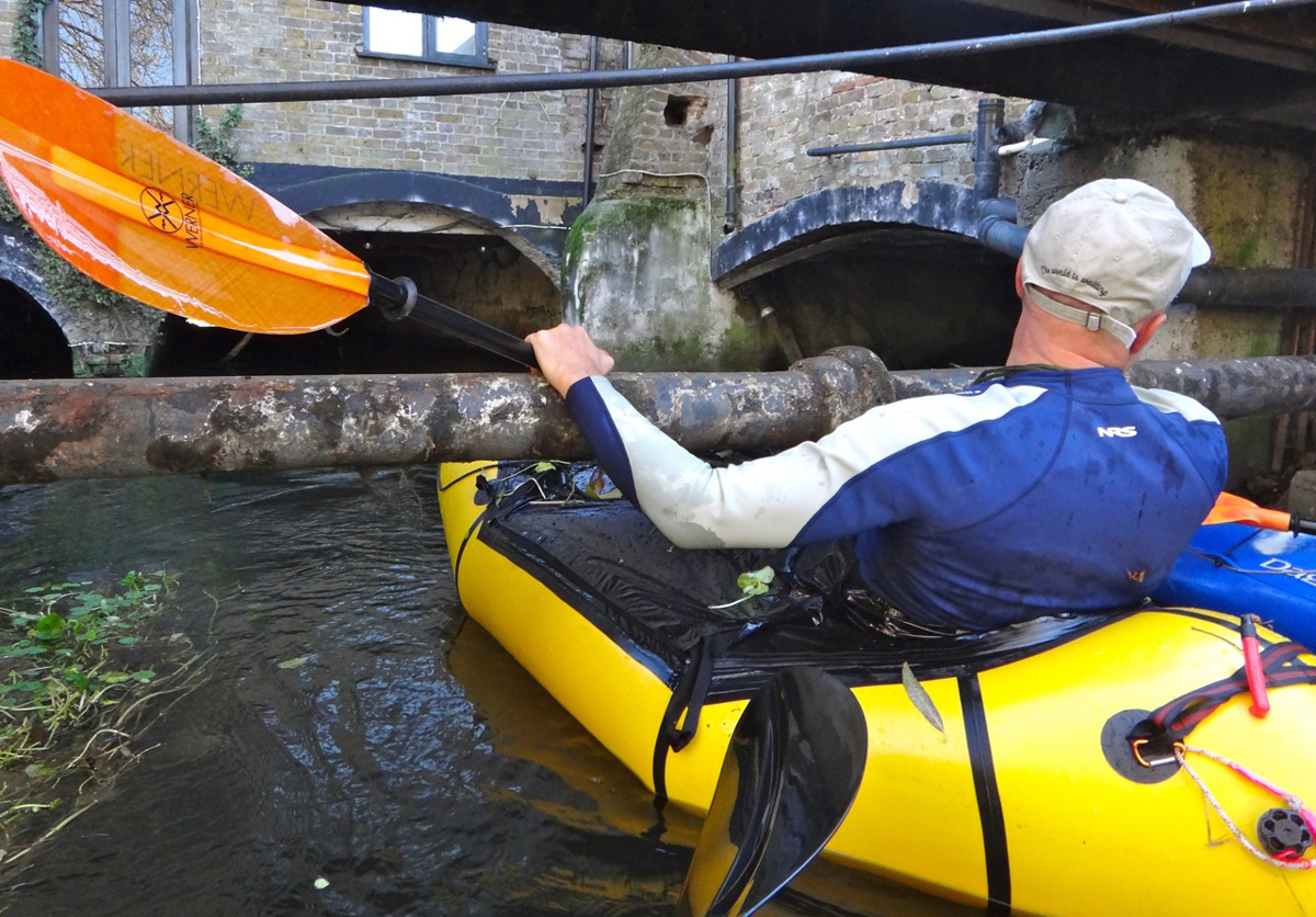
The Canal de la Toba is very much not a recognised recreational paddle backed up by a leaflet in the local tourist board. In fact it’s almost certainly illegal or severely discouraged and could be deadly – like many of Storror’s hugely popular parkouring stunts – or indeed the Kebab Death Tunnel Weir (above) on a bad day.
At one point just before entering a long tunnel they realise that using these rowing rafts backwards, with the thinner, flat-ended stern in front, puts your mass in the much more buoyant ‘bow’, so eliminating annoying back-end swamping when slowing down or when a breeze-driven wavelet passes by.
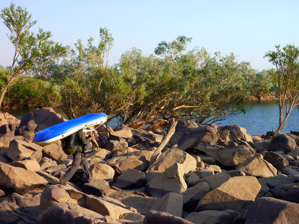
Jeff on the Fitzroy, stern first in his loathsome BestWay slackie.
Going blunt end down does nothing for hydrodynamics, steering or speed, but in the vid the floaters let the canal’s current do the work 12km to the ‘meat-grinder’ grill at the canal’s end, above Villalba de la Sierra. The entire cost of Storror’s seven-boat flotilla was still probably less than the cheapest TPU packraft you can buy today, and like many of the best filmed adventures, it came across as less dangerous than it looked. In a packraft it might have been too easy but let us take heart that the Spirit of Slackrafting lives on.
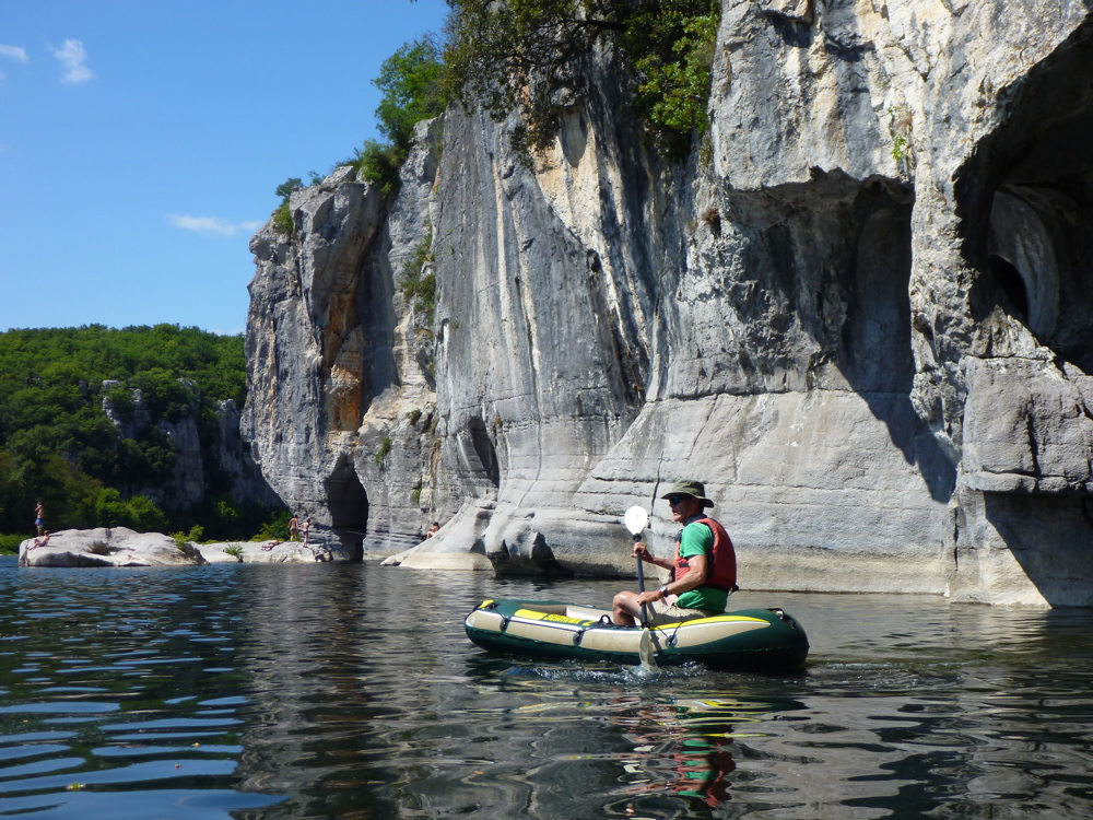
Slacking down the lovely Ardeche. Within a few days the raft was in a campsite dumpster.
I just dug out this story I wrote a few years ago about our packrafting adventure in northwest Australia. There’s more here, including vids. Originally published in Terra magazine2011.
In the far northwest of Australia is a barely tamed region of spinifex-clad tablelands, big seasonal rivers and the world’s largest expanse of tropical savannah woodland. About the size of California but with a population of just 40,000, the Kimberley hosts marginal, million-acre cattle stations, tracts of land returned to local Aboriginal people, remote wildlife conservation ventures and undeveloped national parks.
But the Kimberley might be better compared with Alaska, a wilderness that is under threat. Inaccessible by road for the rainy half a year, the Kimberley is such a relentlessly tough environment that unlike in the rest of Western Australia (WA), exploiting the valuable mineral resources known to be here only now become viable. WA itself is a state the size of India but with 3% of its population, and continues to thrive on a century-old mineral boom. The Kimberley is under pressure to join the party, but as a parallel environmental awareness to conserve Australia’s last tropical wilderness has grown, industrial development of the region has become controversial, not least with the current plans to turn the ochre cliffs of James Price Point 20 miles north of Broome into a vast LNG plant. No one wants to see the Kimberley end up like the Pilbara highlands, 600 miles to the southwest, criss-crossed with private railroads and pitted with huge iron ore excavations as hills are turned into holes to ship the ferrous rubble to resource-staved Far East. But the Kimberley one other abundant resource which the populated southern rim of Australia is crying out for: water.
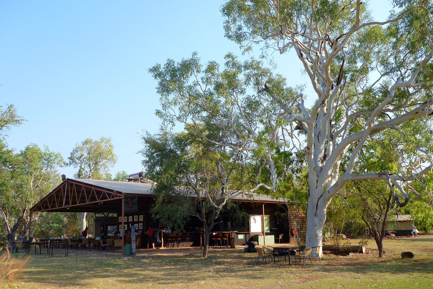
Most visitors experience the same Kimberley; they transit the 450-mile Gibb River Road, a dirt track which bisects the region between the former cattle ports of Wyndham and Derby in the west. With a branch track leading north to Kalumburu on the coast, it’s the Kimberley’s only track, dotted with fern-clad gorges, waterfalls and swimming holes. It was an area I’d visit eagerly when updating an Australia travel guide, often spending too much time and fuel money researching out of the way spots that ended up as just a few lines in the finished book. But even then I knew I’d barely got beneath the Kimberley’s skin and my work there left me wanting to see more. Specialized trekking outfits used local contacts, helicopters and seaplanes to access outback areas, but charged several thousand dollars.
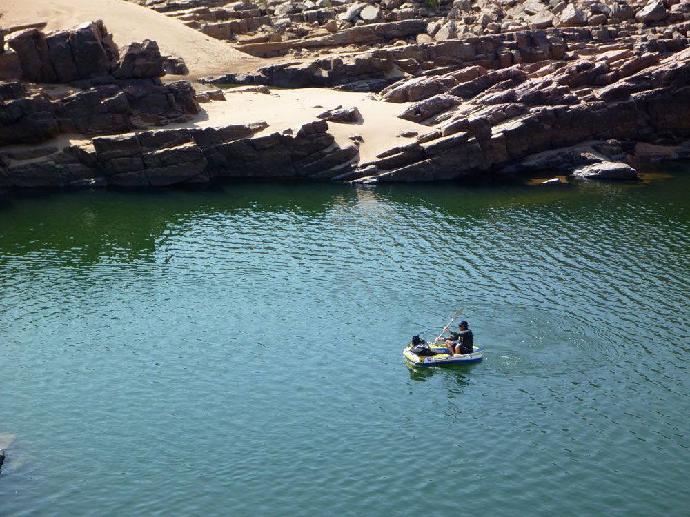
Follow a river – that was the way to do it. With high humidity and average daytime temperatures over 90°F, the constant need for water was solved, while the boat took the weight off feet and shoulders. I’d researched short trips with inner tubes or float bags, but they weren’t really sustainable. Then in 2010 I discovered Alpacka packrafts and knew I had a tough, lightweight craft with which to explore a Kimberley river.
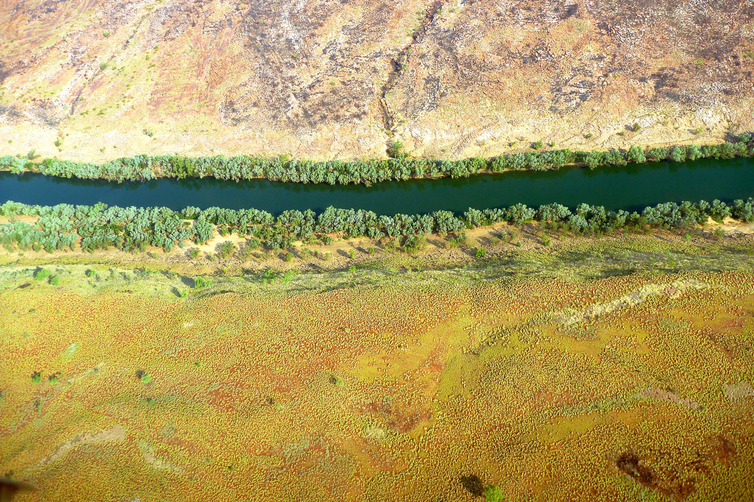
All that remained was to choose a river. Most of the big Kimberley rivers, the Durack, Drysdale and King Edward drained into the Timor Sea lapping an uninhabited and fjord-riddled coastline of 1500-miles on which the small Aboriginal outpost of Kalumburu was the only settlement. But up here the presence of estuarine or saltwater crocodiles as well as 35-foot tides heaving through rocky gaps to form ‘horizontal waterfalls’ made bobbing around in a tiny raft a risky idea.
Horizontal Falls, where the falling spring tide rushes back out of the lagoons through narrow gaps
The key for this visit was to pin down an amenable stretch of water with easy access and exit points and without the menace of saltwater crocodiles. I knew well that no matter how easy you made it – the coolest period, the flattest river – the harsh conditions in the Kimberley would take its toll. My mate Jeff and I didn’t want to be abseiling down ravines, hacking through snake-infested rainforest or looking twice at every passing bit of driftwood in case it slowly started swinging its tail from side to side.
The most likely candidate was the Fitzroy, at 500 miles the Kimberley’s biggest river and in peak flood, the highest volume river in Australia, flowing at up to 30,000 cfs under the Highway 1 bridge at the town of Fitzroy Crossing. Running the churning Fitzroy in the unpredictable Wet sounded a little extreme for me. The good thing with packrafts is that extended portages are relatively effortless; the excess payload adds up to a 5lb raft and a 4-piece paddle. So Jeff and I decided September, the end of the dry season, would make an easier introduction; cooler and less humid just as long as we were prepared to walk between the pools.
Mornington
The take out was obvious: the bridge at Fitzroy Crossing, the only town for a couple of hundred miles along Australia’s peripheral Highway 1. And some eighty miles upriver, Mornington Wilderness Camp seemed like the best place to start. A former cattle station spread across the King Leopold Ranges. I’d visited the Camp a decade or so earlier, soon after the Australia Wildlife Conservancy had taken it over and de-stocked it. It’s one of nearly two-dozen sanctuaries the AWC manages on the continent and at nearly 800,000 acres, one of the largest, with a range of unique ecosystems as well as high levels of biodiversity which included several rare and threatened species.
When we arrived at the Camp, following a 30-minute flight from Fitzroy Crossing, the Camp’s manager Diane was midway through a pre-dawn finch census lasting several days and assisted by volunteers from all over Australia. The ranges around Mornington are one of the preferred habitats of the stunningly colourful Gouldian Finch, an endangered passerine or ‘songbird’ whose breeding patterns and habitats have been disturbed by changes in the bushfire regime as well as introduced predators, topped by the feral cat – the scourge of indigenous birds right across Australia.
When I think of the Kimberley, it is above all the chorus of the largely unseen birds which evokes the spirit of northern Australia’s wild and remote corners. From just before dawn until sunset the bush resonates with avian chattering, from the strident squawks of the corellas, cockatoos and kookaburras, to the milder coo-ing of the crested pigeons. This would be the daily soundtrack for our five-day descent from the Mornington to the highway bridge.
Dimond
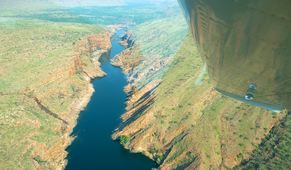
On the water soon after dawn, by the mid-morning of the second day we arrived at Dimond Gorge on the southern edge of the Ranges. Here the Fitzroy cuts back on itself as it pushes past the gorge walls, scoured smooth by the monsoonal torrent. At the southern exit where the gorge walls are just a few hundred feet apart, a dam had been proposed to match those on the Ord river in the eastern Kimberley. In 1960 the original dam enabled the development of the Ord River Irrigation Scheme (ORIS), the new town of Kununurra and with the much bigger Ord River dam completed in 1972, the 400-square-mile expanse of Lake Argyle was formed. But the ORIS has been slow to reach any potential. Thousands of kilometres from its domestic market, the produce, mostly sugar cane and high-value sandalwood, gets shipped to Asia and the power generated from the huge dam only supplies Kununurra and a nearby diamond mine.
Water has become an acute problem in the populated southeast of Australia where the steady depletion and raising salinity of the Murray-Darling basin which fills most of New South Wales and Victoria has led to water restrictions. Meanwhile, on the opposite side of the country, the Fitzroy’s wet season run-off spills into the Timor Sea at a rate of a ‘Sydney Harbour’ every nine minutes, or evaporates from the vast 1000 km² surface of Lake Argyle. This potential was anticipated in the 1980s ago when a 1200-mile pipeline to already drought-stricken Perth was proposed, until it transpired that the cost of securing and delivering water to be six times that of local desalination. And so by 2006 the world’s first desalination plant to powered by a nearby wind farm was opened just south of the city Perth, supplying nearly a fifth of the city’s needs.
Emerging from the uplifted sandstone escarpments of the King Leopolds at lunchtime on the second day, we were having no such shortages. The preceding Wet had ended five months ago breaking all Kimberley records, and as we’d flown into Mornington a couple of days ago it was clear that, against our expectations, below us the Fitzroy was still flowing and four-fifths was open, paddleable water. There’d be a lot less walking than we’d anticipated.
Now, ahead of us lay the cattle country where we expected the river to lose its depth and definition as it meandered southwest among granite outcrops towards the highway. Sure enough, after lunch the flow soon dissipated into a jumbled rock bar with one particularly tough portage over huge boulders which left me croaking with thirst. Walking consumed so much more energy than paddling and we fully expected the stage across the cattle plains of Fossil Downs station to be tough, fly-ridden and with the menace of semi-feral stock.
Although we’d end most days exhausted, it in fact turned out to be the highlight of our traverse. There were no more rock bars but periodically the river’s main channel became choked with flood-borne sand which diverted the remaining flow into the trees along the banks. Here, under a cool canopy of river gums replete with twittering of birds, we’d wade the sandy shallows for hours, towing our rafts like sleds. Occasionally we squeezed under- or climbed over a log jam, or sank to our hips in quicksands.
Jeff was using a $30 PVC pool toy rather than a fancy, $1000 Alpacka, so had to nurse the limp raft and repair punctures almost daily. The cattle and harmless freshwater crocs (a species unique to northern Australia) usually scuttled away or stared indifferently as we sploshed by. At one point the acrid reek of urea announced a huge colony of riverside bats which once agitated, took to the wing in their hundreds with a high-pitched screech. Come the evening, we’d spread out on a sandbank with plentiful firewood within arm’s reach, and set about steadily rehydrating ourselves from the day’s efforts.
By the fifth day we sighted the Geikie Ranges, the northern gateway to an unbroken, deep channel which flowed past the distinctive ramparts of Geikie Gorge National Park. Here, eons of flooding had eroded the former limestone reef into bizarre, scalloped forms. Freshwater crocs laid their eggs on the adjacent sun-baked sandbanks while out in the 100° heat, we paddled into the twilight to complete a marathon 12-hour, 20-mile day on the river. By the following lunchtime we crawled up the steep bank below the highway bridge at Fitzroy Crossing. Jeff could barely face another moment in his excrable pool toy, but like me, he’d followed the river.