
A Grabner Holiday 2 running the weir chutes of the Ammer river southeast of Munich in southern Germany.
Lovely droning. Looks great fun.
Tag Archives: Grabner Holiday 2 kayak
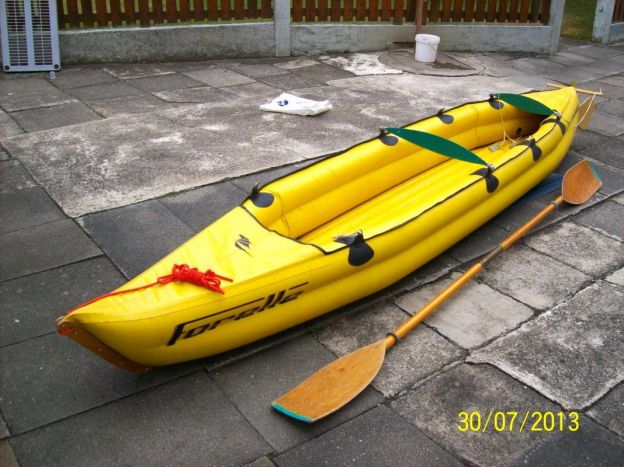
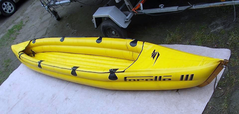
Semperit Forelle: the original ‘proper’ IK
Leave a reply
In 2017 I bought an old Forelle 2. Read more about the…
• …afternoon refurb
• Semperit at Sea
• Semperit at Sea 2
• Semperit Mori
• Semperit autopsy
Not for the first time I will boldly speculate that the Austrian-made Semperit Forelle (‘trout’) or maybe the Dolphin before it, was the first modern IK, designed in the 1960s from tough hypalon ‘rafting’ fabric.
Around the same time Sevylor released the PVC Tahiti watersofa in North America and maybe worldwide. I bet the Tahiti has outsold any Semperit 1000:1 but I know which one I’d rather own.
According to my measurements the Forelle 2 is 3.56m long, 70cm wide and weighs 10.5kg + seat. This guy says Semperit were last made in 1983 at which point (or soon after) Grabner (also Austrian) bought the rights.
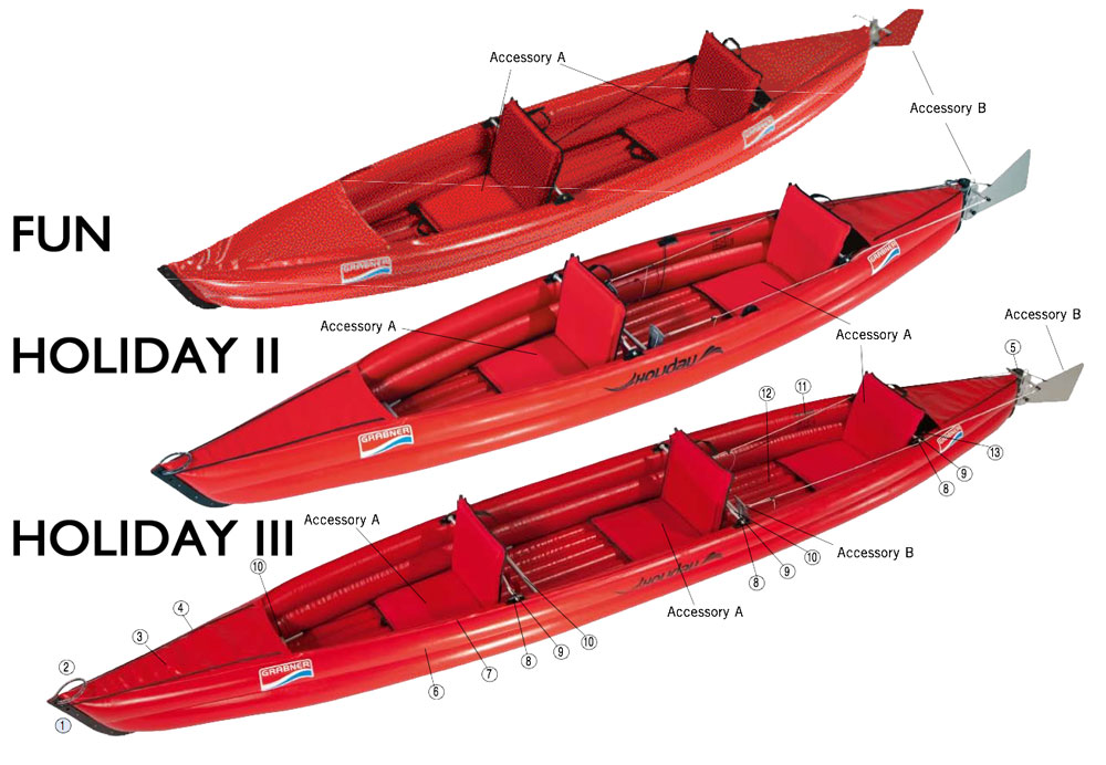
Grabner then got Gumotex, in Braclav just over the border (and behind the Iron Curtain back then) to produce a cloned Forelle called the Grabner Fun (left), but made from Gumotex’s hypalon-like fabric called Nitrilon. Back in the 1980s I’m sure Commie Nitrilon would have been cheaper and nearly as good as DuPont hypalon made in western Europe. The Fun was discontinued (or stock ran out) a few years ago.
Grabner Fun: 365 x 75 cm; weight 12kg; payload 170 kg; pressure 0.2 bar; fabric 1100 dtex Nitrilon
Not being one of their boats, the Fun was undersold by Grabner (notice the table, left). Instead, the similar but longer Holiday range got the fanfare and is still made today with few changes.
Grabner boats are made from a hypalon-like fabric called EPDM which, combined with Grabner’s hot vulcanising method, explains how their boats managed to run 50% more pressure (0.3 bar) than the Fun and other Gumotex IKs at the time. Gael A. paddled an aged Grabner H2 along the Scottish Sea Kayak Trail a couple of years ago. Among others, Incept also used the twin-side beam design to produce a 70-cm wide K40 which is also 70cm longer than the Forelle II, and one of the fastest IKs around.
I would say the obscure and expensive K40 and the more popular but also expensive Austrian Holiday 2 and 3 IKs are modern iterations of the twin side tube Forelle design, along with the Holidays (below) right down to the wooden bow clamp (right).
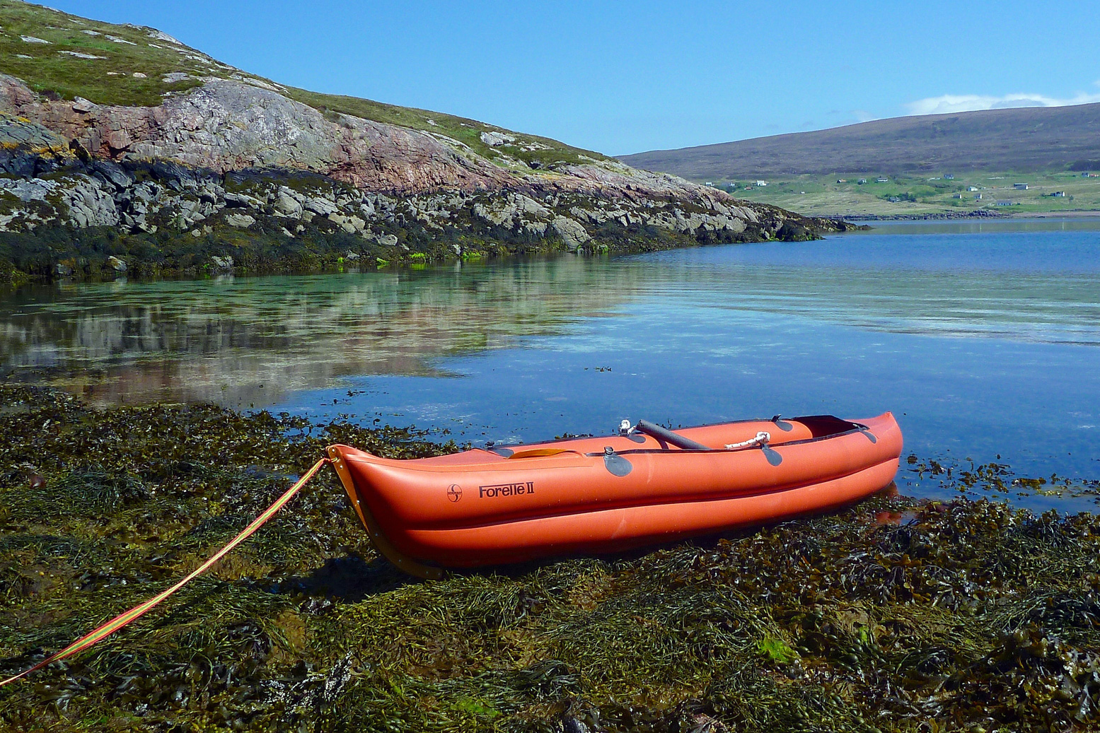
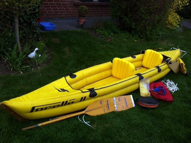
You can occasionally find aged Forelle IIs for around €300 in Germany; a new H2 goes for over €2900 last time I looked, while Funs were being discounted for as little as €400 new, but seem much rarer now. I was curious about tracking down a Forelle recently (I succeeded) and below are a few shots I picked up off the web and from some sellers. Apart from the odd repair, the indestructible hypalon fabric stands up well (or does it?) and the seats may well have been improved (Grabner’s still use crude and bend-prone alloy bars).
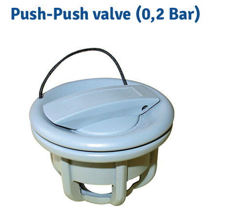
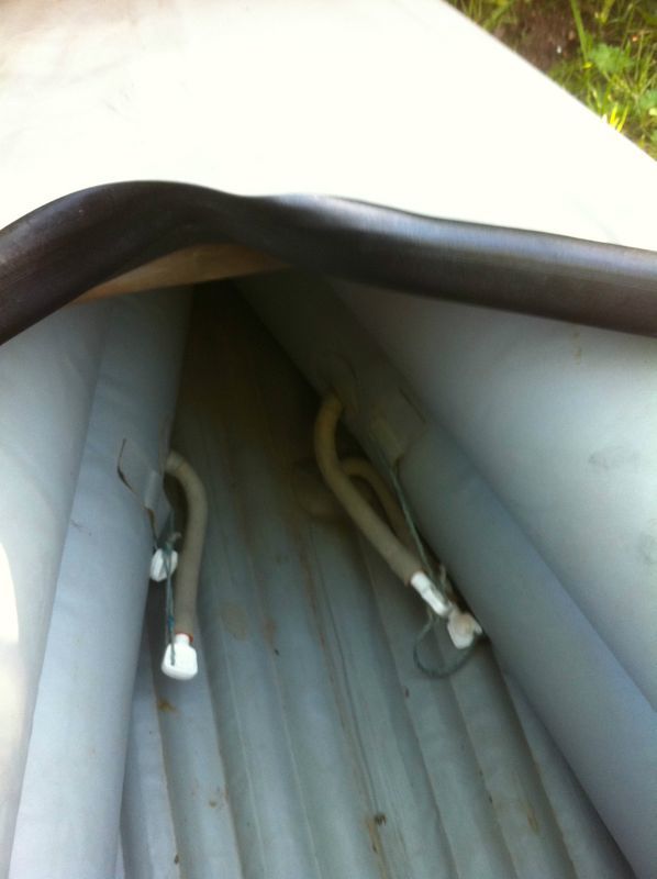
Some boats come with a huge wooden rudder which might be replaced by a skeg, but one off-putting aspect are the basic inflation ‘lilo plugs’ (left); no better than an old Gumotex seat. These could easily be cut out and replaced with proper Gumotex valves (right), maybe in a more accessible position, too.
It seems older versions (grey and orange, below) have a half-inch deep keel strake right along the bottom (as well as a rudder fitting) while later ones like the yellow one, do not.
One thing that can’t get avoided is that a Forelle (and a Fun) still run only 0.2 bar pressure. Same as most ordinary Gumos, like the Solar 3, though the stiffer twin side beam hull helps. Modern Grabners run 0.3 bar which makes a big difference. Some newer Gumotex IKs now run 0.25, though that can be pushed to 0.3 bar with care.
Thanks to Gael and OP for extra details. Most pics lifted from ebay sellers.
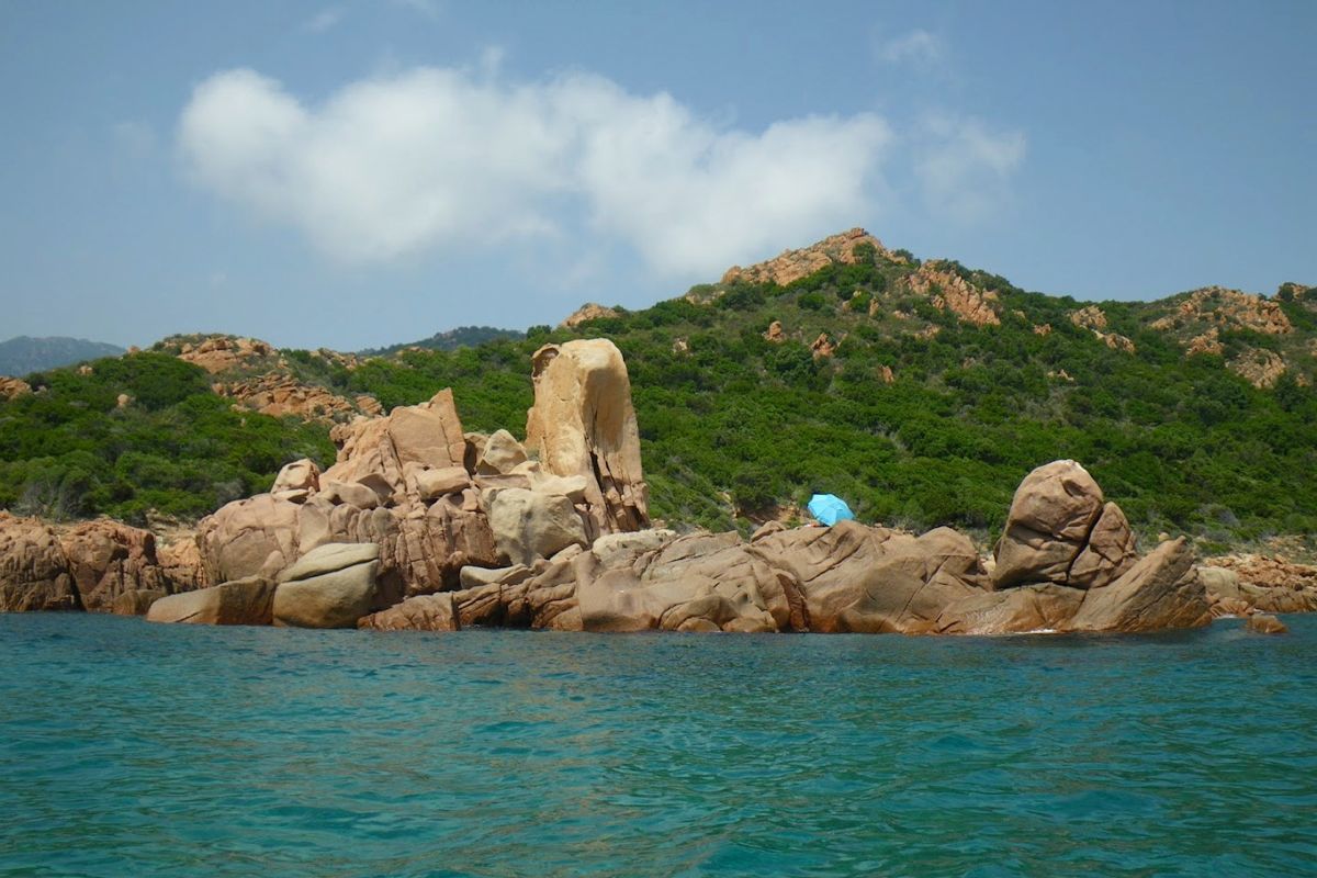
Grabner kayaking in Sardinia
by Gael A

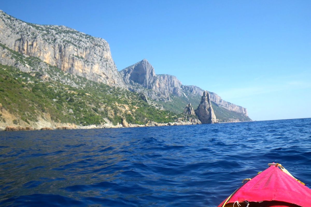
Last summer I spent 3 weeks in Sardinia with my wife. We were camped near Santa Maria Navarrese, a quiet seaside resort and a strategic location from which to explore the splendid and relatively untouched Ogliastra region, located on the central eastern coast of the island. There the mountains rise to over 1000m within 20 km of the shore, hence our plan to combine a beach holiday with hiking and paddling activities. Real sportsmen would add climbing and mountain biking as Peter Harold and his Lemon House guests do. Me, I’d rather add enjoying Sardinian food and wine to the program instead.

I brought my revived Grabner H2 IK. It took us along the astounding coastline to tiny coves that can be reached only by sea. Such fabulous places are found from 20 minutes to 2 hours of relaxed paddling, stopping en route to have a refreshing swim in turquoise water or to stretch one’s legs on a short walk inland into the fragrant Mediterranean macchia.

From Santa Maria Navarrese (aka: SMN) the coast up to north is mostly rugged rock wall all the way to Cala Luna, punctuated by caves, coves and superb white sand beaches tucked under towering cliffs. No easy escape routes leave from those beaches; it would take a few hours staggering along deep codulas (gorges) and up steep and craggy paths before reaching the plateau over the coastal ridge. Although rugged and remote, it’s not real wilderness in summer, because this stretch of coast is travelled all day long by dozens of tour boats and hundreds of rental “gommoni” (Zodiac-style, hard-bottom RIBs) sailing from Arbatax, SMN or Cala Gonone (the next resort north of SMN). Should a boater get stranded he could easily hitch a lift back to port.
Two beaches; Cala Sisine and Cala Luna have tourist facilities in summer such as bar, restaurant, toilets, with employees staying overnight. Sometimes whole families, stay overnight as well. In Cala Luna the restaurant is well known to help ‘naufraghi‘ (castaways); ill-prepared or unintentional overnighters. Sea traffic starts fading from 5pm with the beaches getting covered in shade, and disappears from 6pm to 8am, as often does the sea breeze too, so late afternoon and early morning are definitely the best paddling times. A paddler or hiker traveling this area offseason would be on his own.

So one morning I left for a 2-day trip to Cala Luna and back along the Ogliastra coast. I launched my loaded Grabner in the shore break beating on the Tancau beach.
I jumped awkwardly on board, intending to shove off quickly and not to be dumped back. Unfortunately, my inelegant butt crash-landed right on the backrest. It collapsed under my weight with a sorry crack.
I paddled on to the nearby Santa-Maria Navarrese marina, barely controlling my course in the 2-foot chop raised by the F3 Grecale (NE wind), then pulled ashore on the slipway for repair.
I found no immediate solution to fix the broken backrest bar. The middle backrest was intact but it was too long to fit in the stern backrest position. However, it could be fitted between the new brackets recently added by Grabner. These circumstances forced me to test the solo paddling position which requires only one backrest. I shifted the middle backrest and removed the remnants of the stern one.
Then there was the footrest problem to solve. The footrest is a 2-part aluminum bar. One part is mostly a tube while the other is a plain bar of a smaller diameter which can slide into the tube, so the total length adjusts automatically to the width of the boat for different positions of the footrest. The bent ends of the footrest are tucked into fittings glued on each side of the cockpit. Because of the bent ends the footrest must be taken apart to connect the rudder pedals on it. The crude aluminum material gets corroded quickly in seawater. To prevent it seizing up, I used to spray WD-40 in the tube. Many years ago I once forgot to take apart the footrest and after a few days, it got seized up for good. And now it was too long to fit in the forward tapered half of the kayak. It would be a no-rudder/loose-footrest trip then.
The Grecale abated as I left SMN and headed to Pedra Longa, a conspicuous rock steeple 128m high which stands out of the shoreline. From Pedra Longa I carried on along the boulder beach of Cala Forrola, under the precipitous cliff face of Punta Giradili. In good sea conditions when there is no shore break it’s possible to land safely onto those round smooth boulders. There’s a nice resting spot nearby, with a spring and a large flat slab to lay on for a nap under an overhanging rose-bay tree providing shade from the scorching sun.
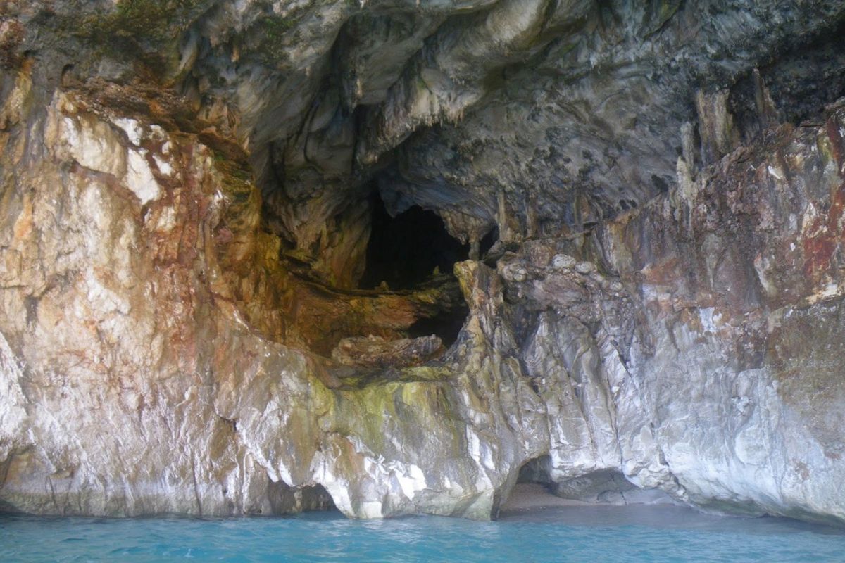
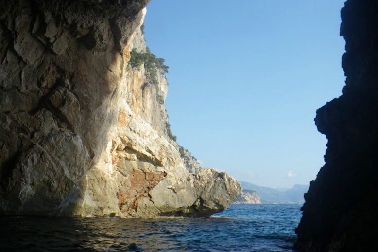
Passed Punta del Pecoraro the coast becomes a vertical wall with nowhere to pull ashore for a significant distance. The only dents in the cliff were the Grotta dei Colombi (cave of the doves) and a sea cave close to the Capo Monte Santu. An opening in the cliff vertical face loomed right under this impressive headland, the entrance of Porto Pedrosu (Grouse Cove).
Porto Pedrosu is a fairly narrow inlet, narrowing even further as it goes deeper inland. It ends on a boulder choked beach, 3 metres wide. The gommoni are too large to get there; they stay on anchor near the entrance of this mini fjord and the crews swim ashore. I filled my net anchor with large pebbles, tied it to my bungee leash and put it on the edge of the foredeck. I pushed my boat out to sea with the painter in my hand. I give it a yank when the kayak was at the right distance from shore and the anchor fell. I pulled the boat back a bit and tied the painter around a rock. The bungee holds the mooring lines tight provided the anchor is heavy enough for not tripping on the bottom. I had the place all to myself for a quick lunch and a short siesta. After leaving Porto Pedrosu I visited Porto Quau (Quail Cove), the next inlet, also like a gash in the cliff, without any landing spot as it is walled in on all sides by plumb faces or piles of tumbled large boulders.
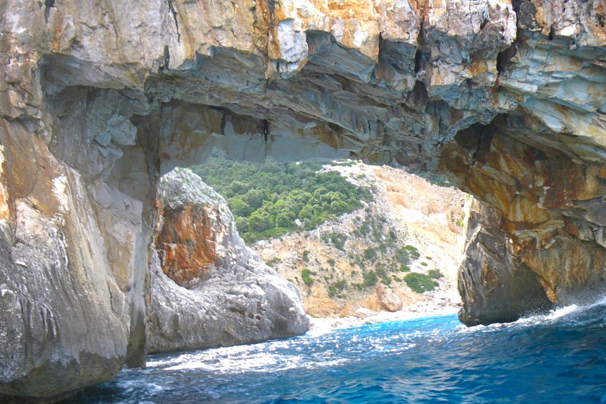
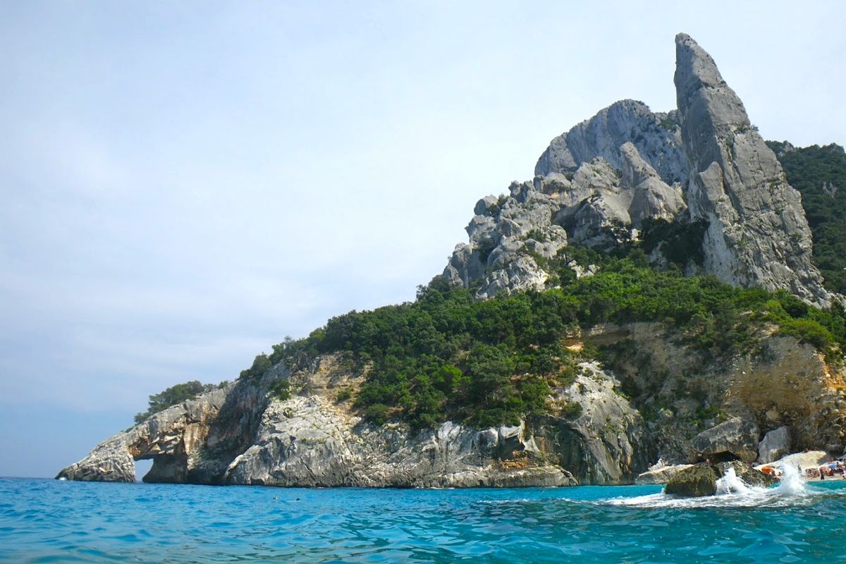
I carried on around the sheer 250-m high Punta Iltiera keeping some distance from the shore to stay away from the uncomfortable rebounding chop. About 3 kilometers later the arch of Cala Goloritze came in sight. I went through the arch, which I had not expected as it usually swarms with swimmers.
The otherwise lovely beach was still crowded with sun worshippers. Unlike other beaches further north, this place can be accessed after a relatively short (1h35) and easy (530m descent) walk from the Golgo plateau above. Italian families get there carrying large umbrellas, beach chairs, beach toys, ice chests and picnic supplies to spend the day swimming, tanning, playing, eating and making an incredible din. The return trudge up the slope with the panting and grunting hoards is quite an experience, like being part of a commedia all’italiana movie. Besides the arch, Goloritzé is also famed for its 127-metre long needle rock, the Aguglia, ‘a sought-after destination for free-climbers’ say the guidebooks. From the sea it looks smaller because all the place is dwarfed by the towering mass of 466-m Punta Salinas.
The next renowned and highly advertised place is Cala Mariolu, a postcard-like white sand crystal water beach. It’s not exactly sand but tiny rounded gravel. By 6pm most boats were gone. I had noticed earlier that this time was the rush hour for tourist boats and rental boats as well. I had seen them almost everyday return at full speed to SMN or Arbatax to get there by the 6pm cut-off.
I passed Cala Biriola while the last batch of people was being evacuated. Groups of visitors are landed on different beaches and for a limited time in order to avoid too many people cramming the same beach at the same time. I was alone on the sea and Capo Monte Santu looked far behind by then. I reached Cala Luna by 7pm. It wasn’t dark but the sun had disappeared behind the mountains. I pulled ashore in front of the large caves located on the north end of the beach.
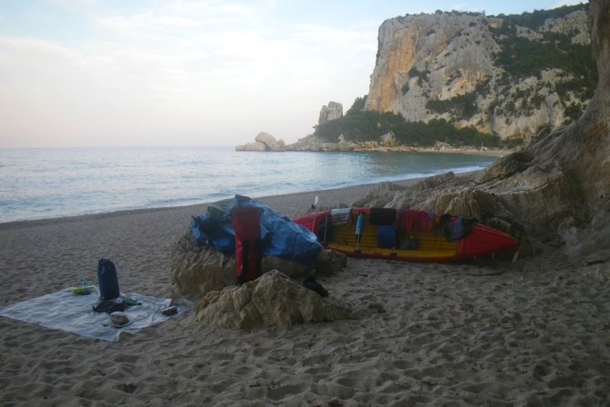
The beach edge was very steep with the typical dumping wave breaking right on it. I looked for the smoothest landing place and stood by for a while before paddling in, timing waves sets. I caught the back of a wave but it did not carry me high enough to reach the flatter ground and I landed on the steep slope. The next wave crashed in, half filling the cockpit, as I jumped out of the boat and grabbed the bow handle – easily done with an open IK. I hauled the boat turned bathtub up the slope and carried the gear near the entrance of a cave. Setting camp was quite simple: laying an old space blanket as a groundsheet on the sand. In the very unlikely case of rain coming, I could go inside one of the caves or retreat into the codula and rig my tarp between shrubs.
Dinner was instant polenta, pecorino cheese, fruit, all washed down with some Ichnusa beer. The issue with polenta – a bit like couscous – is that it has no taste. Simply adding a generous spoonful of butter, bits of cheese and some spices make it delicious (there might be more sophisticated ways to enhance polenta though).
I was a bit tired and I fell asleep shortly after dark under an extraordinary starry sky, sliced now and then by the seasonal shooting stars. Next morning I woke up at dawn and watched the sunrise on the placid waters. The temperature was relatively cool and I stayed in my sleeping bag until 6.30. The obvious upside of outdoors living in warm and dry weather is how little equipment you need. My heaviest pieces of gear were my 10-liter water bag, and a pack of beer. In no time after breakfast I packed up and brought gear and boat to water.
Again I launched my kayak at the wrong time. I thought there was a lull between two bigger wave sets, but I was hit by one before I could jump on board and push-off, right in the dumping zone, at the bottom of the beach steep slope. The boat got instantaneously swamped and severely tossed back toward the beach, pinned down by the waves in the impact zone. Most pieces of gear floated in or around, each held close by its respective tether. The H2 was now a heavy piece of jetsam that I struggled to haul on higher ground.
I bailed the water, secured the gear under tighter bungees and shortened tethers and timed the wave sets more accurately. I put to water again, at the right moment this time. ‘Nothing was lost, only a bit of pride’ as said Audrey Sutherland in Paddling North.
By 8am I was still alone on the water, save for one or two gommoni heading south. I passed Cala Sisine and Cala Biriola, still empty of visitors. The sea was much calmer than the day before, and I could hug the coast and visit many caves and crags along my way southward. At 10.30 the boat traffic was picking up and I stopped at Cala Mudarolu with a deep cave at the end of this lovely cove.
The entrance is barred by a gravel beach. There is water inside, brought by the gales when the sea reaches over the tombolo. Unfortunately, the surface of the pond inside the cave is littered with plastic bottles, soda cans and all sorts of trash. It was 11 and the boat traffic was now in full swing. Fortunately, most boaters hop from one beach to the next, overlooking the rocky shore in between.
I passed the beach area of Cala Mariolu where a large fleet of motorboats was moored beyond the line of buoys marking the 300 meters limit from the shore. At noon the traffic stopped: pranzo time is sacred in this heavenly country. over the next 2 hours all I could hear were the gulls and the water lapping the cliffs, instead of roaring gomo engines.
I gave up stopping at Cala Goloritze, scared off by the crowd on the beach and in the water. Instead, I paddled on to Porto Pedrosu for a quiet lunch stop in the shadow of some Holm oak.
Now it was time to fight the regular SE afternoon breeze around Capo Monte Santu, but the lumpy chop of the day before had turned to a gentle ripple. From half a mile offshore I stared at the stupendous ruggedness of the Supramonte, while paddling my way back to SMN. No polenta tonight, but a hearty 7-course seafood dinner at the Pescheria, a nice restaurant on the shore of the Tortoli lagoon where they even offer to carry you home.
Overhauling a Grabner H2
by Gael Auffret
Gael’s H2 review here,
Compared with other kayaks here
Solo paddle up the Scottish Sea Kayak Trail: Part 1 – Part 2

After more than 12 years my tandem Grabner H2 IK was showing signs of wear all over. The most visible appeared behind the fore half deck where two grommets fed the grab lines (below left). Around those grommets the rubber coating had worn off, showing the bare woven core material of the Hypalon fabric.


I knew Grabner could provide an MRO service as stated on their web site and the French Grabner reseller confirmed he could send my boat to the factory in Austria for a quotation. That came the week later in German, but what didn’t need translating was the substantial figure at the bottom which added up to something like “you’re better off buying a new boat”.
Another major concern was a crack that developed under the aft backrest bracket (middle). This ill-designed bracket has a sharp edge that gets pushed into the skin under the weight of the paddler. After some years of chafing it had worn a small hole that proved difficult to patch reliably.

I must to admit the H2 is not as perfect and tough as I’d claimed so loudly. Encounters with various submerged obstacles and a number of uncontrolled landings had resulted in many scars and scratches all over the hull. I now also own a similar Incept K40 for solo paddles, but as I intended to keep the H2 as a tandem boat, I thought it was time to give it a serious makeover.

Grabner’s attitude to those requiring a more seaworthy kayak than an H2 was get an Explorer or the framed but now discontinued Discovery, but those IKs are way too bulky and heavy (26kg and 29kg respectively) for transportation when shuttling about.

My H2 weighs just 16kg. Plus they are just about the most expensive IKs in the inflatable world (left). I discussed the money issue with the other half of the H2’s crew who happens to also be the purser. She too wanted to keep the H2 and was not as appalled by the cost as I was, so after a short deliberation we decided to proceed.
Three weeks later my local reseller informed me enthusiastically that my H2 was here and beautifully refurbished. Save for the numerous patches it looked like new.


There was a keel strip on the bottom as well. Surprisingly the Austrian guys hadn’t paid attention to the colour of the patches (left). While the inside the H2 is yellow, they applied patches in external red. I should have supplied them the yellow patches I’ve got in my repair kit. Anyway, I’m happy the boat is in such great shape again, if not better than before. I can’t claim it’s worth as much money as I’ve spent on it, but I’m sure my H2 will go for another 12 years.

Scottish Sea Kayak Trail Part 2 ~ Raasay to Loch Torridon

Grabner H2 report • Part 1 (previous) • Part 3 (next)
Scotland 2011
Raasay – Rona – Loch Torridon
On Saturday May 14, I left Paris very early and drove to Scotland. I arrived in Kyleakin on Skye very late the same day. The last leg between Fort William and Kyle of Lochalsh had been tricky because some large animals were standing in the dark by the roadside. I pitched my tent in the grassy backyard of the Backpackers hostel and eventually enjoyed some well-deserved rest.
Morning after, I checked the weather forecast to find out that it was expected to be rough during the next 36 hours, before improving on Monday afternoon.
My plan was to complete in about 10 days the last section of the SSKT, the Northland section, from Kyle to Ullapool. Last summer I had paddled North up to Applecross, visiting the Crowlin Islands en route, as well as Loch Carron up to Plockton and the Black Islands. Instead of following the same route, I intended to visit Raasay and Rona before crossing the Inner Sound to Loch Torridon. This detour would also keep me sheltered from the Westerly winds in the lee of Skye.

Before putting off, I went to the police station in Kyle of Lochalsh to inform them about my intended trip. The officer in charge was very helpful and helped me to turn a « going to the hills » form into a float plan. He took note of my leaving my car at Kyleakin: I did not want to be reported missing in case somebody would draw wrong conclusions after noticing a foreign car left unattended for several days.
I launched in Otter Pond after lunch and started paddling westward, hugging the shore which offered some shelter from the SW breeze. I thought I could reach the SE corner of Scalpay by the end of the afternoon and set camp there, but the wind decided otherwise and grew stronger as I was passing Palbay on my starboard beam. Rounding the low features of Rubha Ardnish I felt the full force of the SW gusts freewheeling across Broadford bay. It would take way too much energy to reach the other side, so I decided it was wiser to call it a day and returned to the lee of Rubha Ardnish.


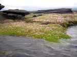
It was high water time. The sea had just risen up its highest, flooding large expanses of grass and patches of sea pinks (armeria maritima). I landed on a bed of flowers and installed my camp at the foot of a rocky bluff offering a natural protection against the wind. Soon the rain forced me to hide in my tent. Cooking outside was impossible so I carefully light my tiny can stove inside and prepared some hot soup.

I took to sea at high tide the following day. Very early then. I had to because the shoals around Rubha Ardnish dry out not long after high water, meaning a long and tedious portage should I miss the time. Crossing Broadford bay against the still fresh SW breeze proved to be a effective warming up exercise.
I stopped on the gravel beach in the small drying harbour, protected by an old and crumbling stone pier where some fishing boats were moored. Through the windows of the hotel nearby, I was watched by guests having breakfast in shorts and t-shirt.

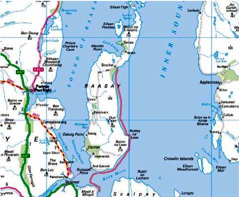
Surprisingly as I left Broadford behind me the wind eased off and I paddled through Caolas Scalpay on mirror like flat water. This bliss did not last and I crossed the mouth of Loch Ainort buffeted by the usual SW gusts. I probed into Caol Mor to assess the conditions for this 2 km passage. I found it challenging enough to make my arms feel weak. I postponed the crossing to later in the afternoon, let the wind blow me back around and retraced my last paddle strokes until I could land on a seaweed choked boulder beach for an early luncheon. One hour later the receding tide had left my boat high and dry but I could easily drag it back to water on the thick and slippery layer of kelp covering the boulders. The 2 km crossing to Raasay went fairly well. To my great satisfaction I was whisked by the wind around Eyre Point then to Rubha Na’ Leac. I landed in the small bay behind this headland, hoping to find a camping spot. There was none so I had to paddle on along steep hillsides and stately cliffs all the way to Brochel.

I landed on a pebble beach below the conspicuous ruins of Brochel Castle. Above the beach was a grassy ledge where I pitched my tent. The evening was calm and dry, so I could enjoy my dinner in the open, watching the Applecross hills across the Inner Sound. I paid a visit to the Castle (which is unfortunately falling apart), but it was too late to have a walk to Ardnish along the famous Calum’s Road.

Forecast for the next day, provided to me by Chris, was light breeze no rain until 7 pm. There were even patches of blue in the overcast sky. I paddled to the north tip of Raasay, entered Caol Rona and turned into the narrow passage between Raasay and Eilan Tigh. A SW light breeze pushed me across Caol Rona and later helped me against the current ebbing out of Acairseid Mhor between Rona and Eilean Gharb. Acairseid Mhor is a natural harbour, and a former smugglers haunt.
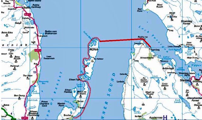

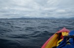
Rounding the North tip of Rona amongst a maze of skerries, I involuntarily scared a score of seals which scrambled into the water from the rocks where they were sprawled. The visibility was good and I could see Rubha na Fearna 9 km away to the East. I looked up to the lighthouse and noticed the flag flying in the wind next to it. The flag was showing that the wind had backed South. That was bad news: I would have to paddle for about two hours in side wind pushing me towards open sea. But the wind was not expected to pick up before the end of the afternoon and I should be safe in Loch Torridon by then. So much for the easy downwind crossing I had hoped for. Two hours later I rounded Rubha na Fearna with a heavy sigh of relief. The wind had alarmingly picked up while I was still in the middle of Inner Sound. The current was running against the wind, inducing some uncomfortable yet manageable chop. I stopped on the sand of a tiny inlet and had lunch.

When I set off again, the wind had backed to the SE. While probably still blowing from South outside, it was funneled along the direction of Loch Torridon. So I trudged along the shore, feeling the wind blowing stronger as time passed, and reached Aird, a headland separating Loch Torridon from Loch Shieldaig. I rounded the north tip of this headland then set a course to Shieldaig island some 4 km away. The wind suddenly accelerated and stopped me in the passage. The water around me became white. I tried hard to move forward, to no avail. I gave up and let the wind push me back out of Loch Shieldaig into Loch Torridon.

Hugging the shore of Aird I paddled into Loch Beag under the pouring rain. I landed on a narrow slipway at the very head of the inlet, next to heaps of creels. Exhausted, cold and miserable I staggered up to a shed were some people were sorting shellfish. The building had an upstairs platform above the working floor accommodating an office, a cloakroom, a kitchen and a bathroom. I was granted permission by the foreman to spend night in the kitchen. This room was also a closet cluttered with various things. The cloakroom stank because of the fishermen oilskins and wellies hanging there, but it was heated and I put my stuff there to dry.

The foreman came back at 7 next morning. I was ready to go and had washed the floor before leaving. Through his binoculars I could see the white crests of rough water outside. However as the wind had veered to SW, it should not prevent me to enter Loch Shieldaig this time.
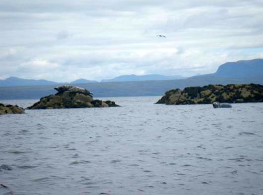
Again I rounded Aird. As expected, I was sheltered from the SW wind. Nevertheless I kept hugging the shore to avoid any risk of being pushed away. I landed on a tiny pebble beach near a shabby cabin. I walked up a soaking wet footpath to explore the woods. There I found an ideal campsite, flat, dry and sheltered by the trees.

I was short of drinkable fresh water. There was plenty of water dripping all over the place but I was not in the mood for going through the process of purifying it, not for setting up a rig to collect rain water, even though I had nothing else to do actually.
Instead I decided to paddle another 2 km to Shieldaig, get some water there and return to my secret campsite. I was halfway across to Shieldaig Island when a powerful SW gust hit and I had to paddle like mad to keep on my course to Shieldaig jetties. I filled my 10 litre waterbag and bottles at the tap conveniently located on the creel-choked platform, after a local confirmed it dispensed drinkable water. I paddled the shortest distance to the sheltered opposite shore and returned to campsite.
The forecast that Chris texted me for the following days was still depressing. There was too much distance of west facing exposed coast on my way up north that I could handle in high winds. So I decided to leave the SSKT here, and accepted Chris proposal to pick me up in Shieldaig the next day. I hoped the weather would improve after the week-end and allow us to explore the Summer Isles. It did not happen.
A wet weekend that turned windy (Incept K40)
Gale warning 23 May 09:53 UTC
Violent storm force 11 veering northwesterly imminent, decreasing gale force 8

That storm hit some 200 miles west of here in Rockall, but you get the picture; it’s kite-shredding weather round here right now. Friday afternoon Ardmair near Ullapool recorded nearly 100 kph (62 mph), while we sat at the window and watched the sound run with streaks of foam. The way it’s blowing now I’d not be surprised if it gets over a 100 this week. As it turns out, along with us, the weather station up the loch went down in a 4-hour power cut at the height of the storm, but by then I read it reached 100 mph (160 kph) on the other side of Scotland.
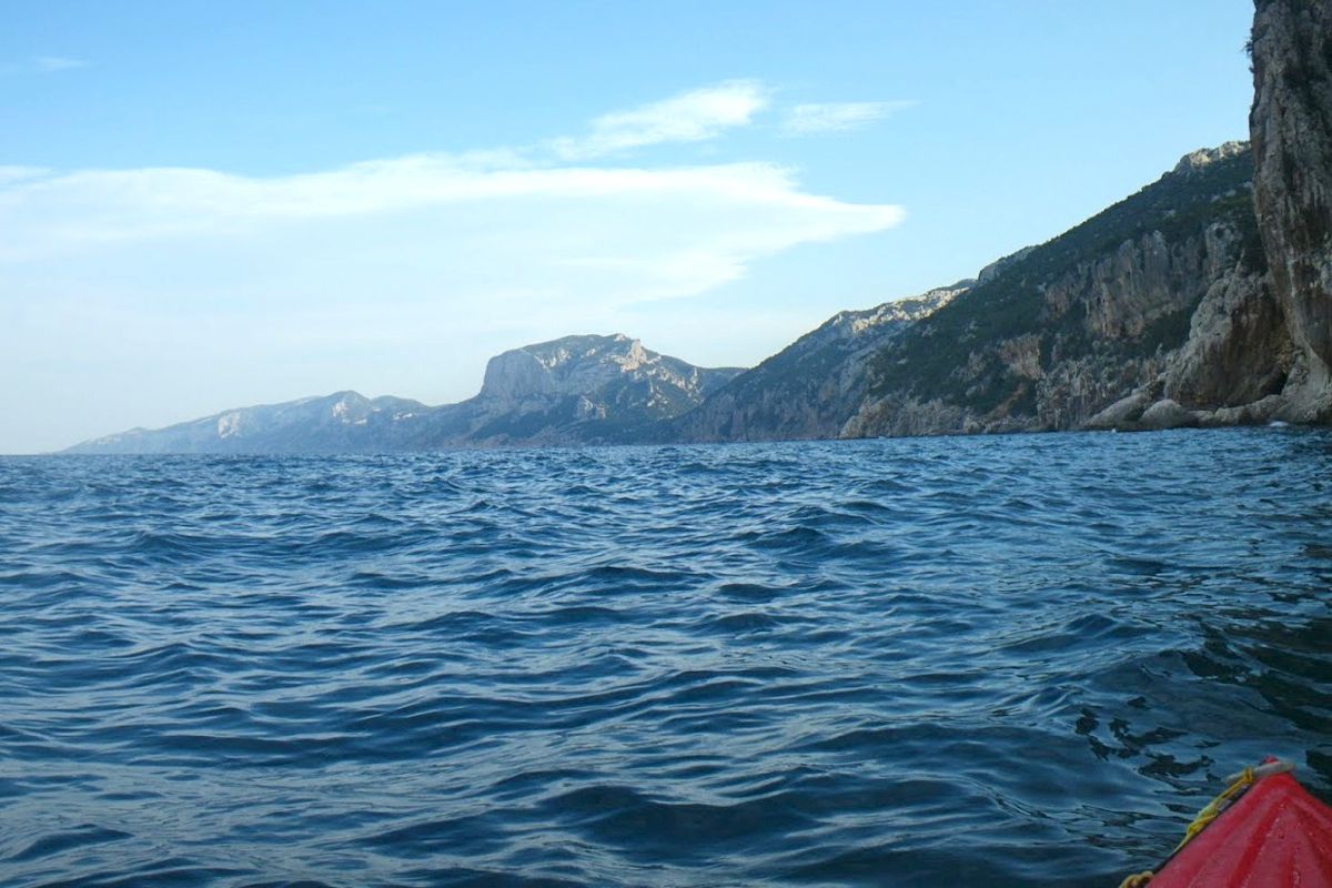
A week ago intrepid French IK sea kayaker Gael A. set off from Skye to complete the Scottish Sea Kayak Trail (SSKT) which he started last August and wrote up for this blog. At that time he managed a fair chunk of the route before the weather turned. This time he was far less lucky; after a record hot April in the UK, May is turning into a bonanza harvest for wind farmers. By last Tuesday Gael had crossed over from Rona island to the mouth of Loch Torridon (above left, midway on the 9km crossing) and got up as far as he could before the fierce wind forced him back to camp.
Next day he reached Sheildaig, at one point noting the spring tide flooding a patch of wildflowers. The forecast summaries I was texting him were not promising: days of F5-7 ahead. He was in a fix because from Torridon he had an exposed 45-km section past Gairloch to get around Rubha Reidh headland before turning east towards Loch Ewe, the Summer Isles and Ullapool, the finish line of the SSKT. Providing we could handle the conditions, Jon and I had hoped to meet him ‘after the scary bit’ somewhere around Loch Ewe and paddle for a couple of days together.

Gael is pretty experienced – 40 years sea yaking man and boy – so by Wednesday night he knew the game was up in the time he had left. Next day I drove down to pick him up and take him back to his car on Skye, if for no other reason than it’s a fabulous drive across Wester Ross that I’d not done before. There are scores of dramatic valleys like that up here and Loch Torridon itself is a fabulous spot I’d like to return to with my packboats. The whole of the northwest above Skye really is something else as the many touring bikers and pushbikers were no doubt finding out for themselves. The tiny hamlet of Sheildaig is a time-lost, lobster-pot fantasy tucked up an inlet. It didn’t take long to find Gael so we went over to his camp by the jetty, loaded the car and headed to Skye.

The Sound of Sleat off Kyleakin (left) was calm enough, but out beyond the bridge the sea had a bit of a head on it. We had a 1970s-era lunch, Gael checked out with the police in Lochalsh and decided to hang out up here on the off chance the weather improved and he or we could make a little tour of the Summer Isles. He was also keen to try out my Incept as his Grabner was showing the years. In fact is was he who last year pointed out that Incept K40 had evolved since I last checked it out. For me it was also a good chance to interrogate an experienced sea kayaker about the Ways of the Sea. Among the many skills I feel I lack is the judgement to know when it’s safe to got out and when I ought to turn back: interpreting clouds and wind changes, forecasts and sea states. It’s a lot of stuff to understand so we spent Friday chatting while refreshing various forecast websites: Saturday looked like a bit of a lull so Jon came up to for a paddling threesome.


We did the best we could on Saturday and set out from the campsite beach (left) to plant our flags on the calm side of Isle Ristol (which you can walk to at very low tide). Old Dornie was standing room only that day as a local skiff racing regatta was on, postponed from last weekend when Jon and I spent our time daring ourselves to do something and go somewhere.


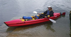
Sat in the back of his aged H2 Grabner like a canoeist, Gael was far more confident than us – pushing out over some surf raised by a reef while we scurried away, appalled. We beached on Ristol for lunch then turned around into the wind blowing through Old Dornie harbour, dodging the skiffing crews (right) hauling out to a buoy and back to the cheers of the crowds until – to quote Gael – it got at least as ‘lively’ (below) as the previous weekend when we’d taken a while to get the hang of it all. Hauling against the wind the two clicks to the main Summer Isles looked a bit of a reach.


We turned back to the campsite launch as it filled with tooled-up sea kayakers who I fear were not going to have the great weekend’s paddling they’d come for. We headed over to Achnahaird Beach on the north side which ought to be either sheltered or with an offshore wind, depending on how you looked at it. Once in, I pointed to a Point and said let’s go there! but the Wise Old Man of the Sea advised we keep along the leeside cliffs in case the wind picked up as was predicted. The sea was flat enough between gusts but had a big, rolling swell which was an odd sensation I’ve not experienced before. I wasn’t sure if I should be anxious or just enjoy the ride.

Once in a while a series of bigger swells rolled by and churned around the outcrops, or crashed against the red sandstone cliffs, but without any real danger to a boater as there was no surf. We’ve all seen impressive sea kayaking long lens shots like that; relaxed yaker in profile with a backdrop of white-foam carnage. Even under skies which looked like they were about to collapse under their own weight (choose any pic nearby), it was a nice end to the day, running past the moss-clad cliffs and spooky caves from which pealed unrecognisable squawks. A lone seal popped up from a distance to check us out and to the east rose the naked spurs of Suilven, Cul Mor and Stac, carved out of the Assynt’s bedrock during the last Ice Age.
Jon glided along in his LV like he was on rails; you got to hand it to these hardshell SinKs, they may be a pain to carry on the Tube but they sure look good on the water – viewed from the stable-as-a-cow-pat perch of an IK, of course! Heck, it all felt like proper sea kayaking. Further up, around Rubha na Coigach headland I dare say it all gets pretty hairy, but it sure would be nice to cruise further along this coast with the Mrs some warm, calm and sunny evening.
And before the weekend was done, Gael got onto Sea Kayak Oban and bought their K40 test boat which I tried out last March. He got a great deal all things considered; I’d have bought it myself had I not already ordered my yellow boat. So that’s at least two K40s in action on the high seas; mine, his and maybe yours too soon.

Scottish Sea Kayak Trail Part 1 ~ Gigha to Skye
Gaël Auffret
Grabner H2 report • Part 2, May 2011 • Part 3, May 2012

I was not actually used to camping in the rain. My personal survival mode turns on with the first rain drops. I started worrying about staying dry when I heard the rain drumming on my tent that first morning in real Scotland. When I had decided to do a paddling trip along the Scottish west coast I knew what to expect. I was prepared and had enough room in my tent to dress and pack critical items such as my sleeping bag in drybags. Removing the inner tent gave me even more space to have a comfortable breakfast. When I broke camp the only wet thing was the tent flysheet. Yet I still wondered how long I could cope with these conditions. I had spent this first rainy night in a campground near Luss, on Loch Lomond west shore. I had arrived there at dusk the day before, after a long drive from Paris. The beauty of the landscape made me forget the weather as I drove along Loch Fyne. Inveraray was packed with tourists despite the showers. The rain didn’t stop until I reached Tayinloan on the west coast of Kintyre. I thought I’d find the Oban tide table in the tiny shop but I was wrong. I had to return to Tarbert where I should have stopped earlier. There I found the Oban tide tables at the tourist office. I bought some midge repellent, bread and peanut butter.

It was still early afternoon and I had enough time to cross to Gigha and set camp at the Ardminish boathouse, but I had to solve the problem of where to leave my car. According to the SSKT guide book I could leave it on the ferry car park but I didn’t want to worry about it during the next 2 or 3 weeks. So I decided to go to the Point Sands campground and get permission to leave my car there. I pitched my tent on the grass just behind the beach and spent the rest of the day preparing next day’s navigation on maps.
First paddle strokes in Scottish waters
No rain this Sunday morning. I inflated my Grabner IK (inflatable kayak), sorted out my gear, packed it in the appropriate drybags and carried it all down the beach. It was low tide. The sea was calm but the low and dark clouds looked ominous. I was ready to push off at noon. Soon I was riding the small chop of Gigha sound, and I relished this moment that I had longed for many years.
The 5km crossing to Gigha was the first leg of the trip. It was neap tide so the current in the sound was negligible. The paddling conditions were good so I could skip stopping at Ardminish Bay and paddle on towards the northern tip of Gigha. Thanks to the excellent visibility I could see the Gamnha Gigha rocks and light, and identify Rochanan Point in the distance. I took aim and paddled across the sound again and had a first encounter with seals on Gamnha Gigha. They are the same color as the rocks so I noticed them only when they started moving.
I landed on Rochanan Point after 4 hours at sea. I was hungry. A NW breeze took up while I was having lunch. The wind and the chop were manageable and I crossed Loch West Tarbert with reasonable effort. I went around Ardpatrick Point then to Rubha Cruitiridh across Loch Stornoway. This bay was a possible landing if the conditions worsened and prevented me getting round Kilberry Head. I stopped on a small beach to relax, have a snack and empty the boat of the water that had splashed in during the crossing. The wind kicked up again around Kilberry Head and the clapotis rocked my boat in all directions. The rodeo-like ride went on until I passed Port Ban.
Soon I landed in Miller’s Bay on a postcard-perfect sandy beach. Behind it I found a grassy spot occupied only by two sheep, half a dozen cows and many rabbits. I pitched my tent, gathered wood, cooked some noodles and watched the sunset. My first paddling day in Scotland was almost over. I had paddled 32 km (20 miles), overcome the head wind and ridden the clapotis. I had faced the same conditions many times before, but for some reason I had thought it would be more difficult in Scotland. Of course I was wrong.
Through the Dorus Mor
I expected to meet the same conditions along the following sections of the route. But Kilberry Head was the last exposed stretch of coast before a safer area of inshore waters. I was now protected from offshore weather by the high paps of Jura. The conditions that usually make this place tricky are strong currents during spring tides and south-westerly wind. Tides were neap so the current was negligible, and the wind was just a light northerly breeze. Fortunately for me the danger that the SSKT book warns against were non-existent and the crossing to Point Knap was like paddling on a pond.
Rubha na Cille
I stopped for a quick lunch near Rubha na Cille and indulged into a short nap before taking to water. The sea was flat now. The breeze died as I was ploughing my way towards Carsaig Bay. Paddling on this mirror-like water would have been boring save for the fantastic landscape I had around me. I had never met such incredible skies, nor such mountains towering above such a glistening sea.
I didn’t find a camping spot around Carsaig Bay but had enough time to pass the Dorus Mor with the end of the flow. The, dead calm conditions were ideal for this passage. From Ardnoe I took a course to Garbh Reisa, the island marking the entrance of the Dorus Mor. This passage is a dangerous race in spring tides. The instructions given by the SSKT book were to reach the entrance at slack water and go with a beginning tide. They were valid for spring tides, but it was neaps and my plan was to cross at mid-tide to take advantage of the fastest current and add more distance to today’s mileage. I was late and I started feeling some current only when I reached the north tip of Garbh Reisa. To the west appeared the gap between Jura and Scarba, the infamous Gulf Of Corryvreckan, where a deadly whirlpool forms in spring tides. I gently glided around Craignish Point then turned north, expecting some push from the remainder of the flow. I looked to the shore to assess my speed: I was stuck, even being pulled slightly backwards to Craignish by some invisible eddy. I was not sure of the right move to make, get closer to the shore or away from it and closer to Reisa Mhic Phaidean. I had read that currents might be surprising in this area so I took the first option. I followed the shore until I found a suitable landing and camping spot in Bagh Dail nan Ceann, where I arrived just as I began feeling sore arms.
After pitching my tent in the tall grass, I picked some wood for the stove. I found a rather big piece on the pebble beach and used my folding saw and Finnish knife to split it into kindling. I kept my Yak paddling suit on as a camp suit and it worked well, keeping me warm and dry without overheating while paddling or shivering while on the shore.
Inshore waters
I woke up to the song of rain and wind. No surprise; the forecast had announced moderate wind save for squalls from the West. I had company under the tent flysheet: slugs and frogs were having a morning meeting on my face.
The first effort of the day was to get out of my sleeping bag, the second was to put on my Yak trousers inside the tent. They were cold and clammy and making my feet break through the latex ankle seals was a chore. The rain stopped and as the sky cleared I enjoyed the view on distant islands to the west while sipping some hot coffee.
After an easy crossing to Luing via Shuna south tip, I paddled northwards hugging the shore of Luing to dodge the ebbing current in the sound. I stopped in Toberonochy where I could get some water from a gentleman who stopped some masonry work to fill my water bag. I went around Torsa in the company of seals and rode a convenient eddy created by the current ebbing from Cuan sound that brought me to Seil. There I stopped to wait for the flow at the entrance of the sound of Seil.
I entered Clachan sound not long after low tide but there was enough water for my kayak to glide over the kelp. Soon I passed under the famous bridge over the Atlantic, then through a narrow and shallow canal, and eventually emerged among some islets just north of Puilladobhrain. There I met a group of kayakers from Oban. Their leader came over to say hello. She even added that my kayak was nice. I was surprised as most hardshell sea kayakers usually find any IK ugly. We parted company and I headed to Kerrera taking a direct course to Rubha Seanach, Kerrera’s southeast tip. It was an open passage, out of the protection of any island. Mull was too far away to offer any significant shelter from the westerly breeze but it was manageable and I liked to feel the moves of the swell again after two days of lake-like conditions.
The impressive Gyllen castle came into view and soon I entered Port a’Chaisteil. There a confused clapotis was stirring the water, making shooting pictures difficult. It was no better in Port a’Chroinn, the beach on the southeastside of the Castle. I went out of the bay, turned left around Rubha Seanach and entered the relatively flat waters of Kerrera sound where I paddled downwind up to Little Horse Shoe Bay, looking for a suitable campsite.
Crossings – Kerrera to Kilchoan
I was thinking about today’s route while spreading a thick layer of peanut butter on a Breton pancake. I had water for at least another 2 days, food for another 2 weeks. I had OS maps covering the coast up to Lochalsh and the Skye bridge. I needed no additional equipment. In short needed nothing in Oban. So why bother? I decided to go around Kerrera clockwise instead. The west coast of Kerrera was rugged and beautiful. The view over the Firth of Lorn to Mull and the distant Morvern hills was promising. There was no shipping traffic except some fisherman and a barge or two. The ferry traffic was concentrated in Mull sound, going to and from Oban on a route that passes between Lady’s Rock and Lismore. I stopped on a shingle beach in Slatrach bay. This place offered superb camping and I promised myself to return and spend some time here. During spring tides the crossing to Mull has to be accurately timed in order to avoid being dragged in the race that forms between Lady’s Rock and Duart Point. It was still neaps, the tide was ebbing and I would just need to compensate a slight southbound current. I took a course to Grass Point against a moderate headwind. The visibility was excellent until I reached the middle of the 6.5 km (4 mile) passage where I saw thick cloud rolling down the slopes of Mull to the head of the sound, progressively concealing the landscape. I watched Lady’s Rock lighthouse as it started fading in the haze, while Eilan Musdile lighthouse was already invisible. I was now facing the situation I feared so much, being caught far from the shore in the way of large ships with little or no visibility. I knew it was strongly advised to have a VHF radio ready in busy waters, but I didn’t think it could prevent a collision. I ought to be wearing a fluo jacket but I had forgotten it in my car. I had the one solution every sea kayaker has left to escape the danger zone: paddle faster. So I did until I reached some fishnet buoys which were a sure sign that I was out of the shipping lane. I reached Mull and hugged the rocky shore. The wind picked up and showers became stronger and more frequent. I paddled under the conspicuous crenellated tower which ornates Duart Point; a heavy shower prevented me to take a picture of this famous landmark. As I came closer to the tip of Duart and entered the Sound of Mull, I was hit by a strong northwest breeze which was funneled between Mull and Morvern. I struggled harder to make headway and reached the foot of Duart Castle. I managed to take a picture of it although I was tossed by the waves and carried away by the wind. I turned into Duart Bay and landed on the beach. I had lunch in the shelter of some bush. Then I huddled under my poncho and fell asleep, impervious to the showers lashing down around me.
Returning to the beach after a walk to the castle, I found that the wind had dropped and although it was already late in the afternoon I had time to paddle further to the west. The receding tide had left my kayak high on the sand and I had to perform the whole unload-carry-reload process before launching. I went against the now reasonable headwind and after crossing Craignure Bay I found a suitable campsite in a meadow close to Scallastle golf course. Two eagles hovering over the shingle beach and a group of deer strolling nearby were my only companions. I cooked my dinner behind a bush that protected me from the cold wind before showers pushed me in my tent to eat my noodles.
Next morning brought more showers and gusts. I crossed to the Morvern shore as a cargo ship was coming from the west. I thought I had plenty of time to hop from Glas Eileanan lighthouse to Eilean Rubha and Ridire skerry, but once in the middle of Sound I saw the ship features alarmingly growing fast so I sprinted out of the way.
I followed the beautiful Morvern shore and had my first encounter with otters. At first I was surprised by the sight of two long-tailed furry animals running on the kelp then jumping in the water. I stopped nearby hoping to spot more otters while having lunch, but none showed up. Despite the intermittent drizzle the place was lovely. Further up the Sound I landed in Lochaline near the ferry pier. For morale building I had a coffee and a scone at the small coffee shop.
Another 14 km further west I crossed again the Sound from Dun Ban to Rubh’an-t-Sean Chaisteil. I landed on a shingle beach next to a stream to check for a possible campsite. Up above the beach I found a flat grassy shelf at the bottom of the hills, a perfect spot obviously often used by other kayakers. Several cairns had been erected by previous visitors and pipes were arranged as benches around a fireplace and there was dry wood stored inside, of which I used only a few twigs.
The wind had backed to southeast during the night, bringing lukewarm but wet weather. Paddling through the Doirlion a’ Chailbhe narrow channel, I entered Tobermory under a low grey sky. Fading in the hazy drizzle the famous brightly painted houses lining its main-street appeared paler than usually seen on postcards. I landed near the harbour office. My paddling suit was dripping on the floor as I asked the weather forecast from the woman behind the counter, drawing disapproving gazes from the tourists. She produced a printout of the met office web page. I had no glasses and she lent me hers. She called me back as I started walking away still wearing them. The forecast confirmed light south to southeast winds all day, perfect for crossing the Sound then Loch Sunart mouth to Kilchoan, then skirting Ardnamurchan. The wind would carry me directly to Kilchoan but I had first to cross the shipping lane. Although there was less traffic than the day before, I thought the direct route was not safe, so I decided to cross the Sound from Calve Island to Auliston Point. On the way I checked the waves were not breaking on Big and Little Stirk, a clue that the sea would not be rough around Ardnamurchan. Three otters welcomed me at Auliston point. I went on across Loch Sunart to Maclean’s Nose, the wind and the waves pushing me gently to my destination and I landed on a skerry just outside Kilchoan.
Around the Ardnamurchan peninsula
There was a small celebration in Kilchoan. I could see it from the skerry where I was having a quick lunch. The forecast I had looked at in Tobermory’s harbour office announced a north wind tomorrow while confirming a southerly light breeze for today. Therefore the best time to go around Ardnamurchan was Right Now! From the map and the guide I knew that between Sron Bheag and Ardnamurchan lighthouse there would be no escape route for about 10km. That was at least two hours strung out below bleak cliffs from which waves bounced back creating an uncomfortable clapotis of mixed-up water. I hoped to encounter dolphins or even Minke whales as promised in the guide book, but the sea around Ardnamurchan was empty save for the usual birds although I did see the fin of a basking shark. Even though I had ideal conditions for this section, I was relieved when the tall figure of the lighthouse came into view.
Sandy Sanna Bay lived up to its description and I relished paddling among the scattered skerries and along its perfect beaches. I carried on past Sanna Point because I believed it would be more difficult tomorrow when it would be exposed to the forecasted northerly wind. However, I could not find a safe landing spot in the bay east of Sanna Point so I came to the Bay and landed on the smooth sand of a west-facing beach protected by a barrier of skerries. It had been a long day on the water. I was tired but happy to have overcome this major headland so easily. The hard part was still to come.
Next morning the expected northerly was on and the sea was scattered with whitecaps. I launched in incredibly transparent water, glistening under the sun already high in the blue sky. The Small Isles were clearly visible to the north. Leaving the shelter of the last skerry I ploughed into the steep waves around Sanna Point then paddled a long 8-km stretch of beautiful though threatening jagged cliffs. I could tackle the beam sea but the ride was pretty wet as some waves crashed over the port side of my kayak and took enough water to feel the cold around my ass.
I landed on the tiny beach in Fascadale Bay, timing the wave pattern to avoid being dumped in the sand. I needed a short rest before resuming my struggle to prevent the wind and the waves hurling me onto the rocks. I bailed the water from the Grabner, launched and went out punching through the chop, taking on as much or more water in the process. Some day I should rig a deck cover to this boat! As I paddled to Rubha Aird Druimnich headland a sudden and stinging hunger hit me. My paddling pace and my speed dropped alarmingly as the power in my arms and upper body vanished. I devoured a handfull of nuts and sultanas and all my sesame bars, sucked most of my water bottle and resumed paddling at a slower pace until I felt my strength back. Rubha Aird Druimnich seemed discouragingly far and I felt like I’d never reach it. But stroke after stroke it slowly loomed larger until I could see the cormorants drying their wings on its top. I rounded the point and enjoyed the wind and waves pushing me towards the conspicuous beach of Camas an Lighe where I noticed a narrow opening cutting into the rocky shore. I paddled through it and entered a pool which formed a perfect natural harbour, sheltered from all sides. Above the beach among the trees were an abandoned cottage and a decayed boathouse. It was the beginning of the rising tide so I moored the kayak, took my day bag, found a convenient rock to sit on and had the lunch I’d been longing for hours.
Castle Tioram in Loch Moidart is an impressive building. Except at high tide it is accessible from the mainland, so tourists were coming and going. Although there was a flat patch of grass providing an adequate campsite just near the little beach I decided to find another place to pitch my tent. I eventually landed on Riska island. There was a great camping spot but the ground was soaked. At least I could verify that the floor of my inner tent was watertight.
Next morning I was invited to have a coffee on board of a Polish sailboat. I had met Jeff, her skipper, on Tioram the day before. He had sailed single-handed from Gdansk. We had both been alone for a long time so we were both happy to have a civilized conversation with another person (after 2 days alone I start speaking aloud to myself). Time passed without my noticing until when looking over the rail I saw that the tide had reversed. I jumped in my kayak and pushed off. I paddled out of Loch Moidart through the south channel, for the eastern section of the north channel was dry. As I was rounding Shona’s southeast corner I went across two cruising Wayfarers heading into the Loch with the flow.
I stopped for lunch on a lovely beach facing south on Samalaman island, then carried on to Glenuig where I refilled my water bag at the inn. Instead of heading to the northeast I paddled east up to Eilean nan Gobhar at the mouth of Loch Ailort. My goal was the Iron Age fort supposedly crowning this rock but I did not see any. Then I set a course to Eilean a t-Snidhe and paddled towards the declining sun setting behind the Small Isles. The conspicuous Sgurr of Eigg provided a perfect landmark to aim for.
Soon after rounding the southwest corner of Rubh’Arisaig, I started looking for a campsite. I noticed two dinghies which had been hauled up the beach. I went closer and recognized the unmistakable features of the two Wayfarers I had met earlier near Loch Moidart. Four tents were pitched on the grass shelf above the beach. I assumed there would be room for a fifth one so I went ashore. I walked up to one of the larger tents where a group of eight people were having dinner. I said good evening and asked permission to share the place, which was joyously granted. Meanwhile, a herd of cows came to inspect my boat. They soon invaded our camp until we drove them away by yelling and waving arms frantically.
The Scots invited me to join them around the bonfire they had lit on the beach. We swapped boating stories while sipping cider. They had caught only one mackerel which was being cooked on a flat stone put close to the fire. The kids were grilling marshmallows on sticks. As one boy was trimming his stick with the tiny saw blade of his little SAK, I handed him my Fiskars folding saw saying “you’d rather use a real saw”. Then his father produced a beautiful folding bucksaw out of a bag and said “THIS is a real saw!” Never underestimate the amount of gear a Wayfarer crew can carry. Those two families had sailed their Wayfarers from Glenuig to Eigg and Muck. They were just returning from these isles when I met them this morning. They used to stop on this beach every year. I heard that Dougal, one of the boys, was a piper. I told him I’d like to hear him. A moment later he was back with his bagpipe and played standing in this darkness so particular to places where the sun set in the sea. Huge and low black clouds invaded the sky to the west and we felt the raindrops and the wind started a song that meant it was time to go to bed.
I pushed off late in the morning after waiting for a southwest squall to calm down. The sea flattened and the sun broke through the clouds. I entered the Arisaig skerries at low tide and there was not enough water left to get to Luinga Mhor. I landed on the sand and had lunch under a sunny blue sky. My Wayfarers companions had told me there would be many kayakers in this area, but I only met one group of half a dozen French paddlers who was picnicking not far from me. I paddled up Loch nan Ceall with the rising tide. My timing was right so I could land just in front of the Spar store in Arisaig. I pulled the boat onto the seaweed and moored her to a rock. At the grocery I indulged in some candy bars and a pack of beer as a treat for my birthday, packed the supplies in my daybag and put to sea. I paddled two miles against the southwest wind and the tide before turning north. There was enough water to take the short cut passage between Eilan Ighe and the mainland. I hopped downwind from skerry to skerry along miles of white sand beaches until I reached the bay of Morar. The map didn’t show any convenient landing till Mallaig, so I turned back and went ashore at the tip of a headland located near the famous Camas an Daraich, landing on a tiny beach tucked between rocks and grassy dunes providing shelter from the southwest breeze.
The wind had veered to northwest again during the night and the temperature dropped significantly so I was shivering when I stopped in Mallaig. I expected this place to be bustling with tourists but I was alone on the slippery slipway in the southeast corner of the harbour. My initial plan was to leave the boat there and to walk to the Fishermen’s Mission for coffee and scones. Forget the coffee, I pushed off and vigorously resumed paddling in order to warm up, motivated by the beauty of the landscape offered by the Cuillin hills rising in the northwest and the Knoydart mountains across the mouth of Loch Nevis. There were no boats on the water, just a fisherman raising his lobster pots off the Knoydart shore. He kept me company to Doune, where I landed on the pebble beach one hour before low tide. The sun came back out and I spread my tent to dry on the boulders. Above the beach was an array of wooden bungalows so I went exploring. A chambermaid explained the place was a kind of hotel where the guests come by boat since there are no roads. She showed me to the kitchen where the cooks refilled my water bag. They were preparing scones, cakes and other good stuff. It was smelling so good but I was not offered anything except a shower. I felt slightly ashamed of my stinking, but only for a split second.
As I paddled past Airor I enjoyed a short spell of dead calm. To avoid overheating I took off my PFD and cag. It lasted all of 15 minutes before the wind picked up again from the north and I had to put it all back on. From Rubh’Ard Slisneach I took a course to Rubha’ a’Chaisteil on the north shore of Loch Hourne. The north headwind slowed me down so I had plenty of time to gaze at the beautiful Loch Hourne mountainous backdrop. I reached the opposite shore, paddled on to Sandaig and landed on the beach to take a picture of Gavin Maxwell’s cottage. I was mesmerized by this place. After a nautical exploration of the islands in company of ubiquitous seals, I landed and made camp on one of them.
Stuck in Sandaig
I was in the last phase of my breaking camp routine. All gear was packed and I just had to pull off some pegs and take down the flysheet of my tent. But suddenly the wind picked up in a series of gusts and showers. The sea to the northeast was all whitecaps and the temperature plummeted. I was expecting a spell of fine weather from the building of a high-pressure shoulder on the area but this was evidence that a front had found his way around the high pressures. The resulting gradient just meant stronger wind blowing from where I wanted to go. So much for a triumphant arrival in Lochalsh today. I was stuck in Sandaig. Bound to stay in my tent by the rain, I spent this forced day off reading, planning future navigation, making a list of supplies, but mostly dozing, stunned by the hammering of frequent downpours. I could not use any stove inside tent, so I ate cold meals of Mediterranean cereals, a kind of couscous that only requires some water on it. It’s ready after half an hour once the cereals have absorbed the water. I had also cheese, saucisson, bread, butter, dry fruits, neither requiring any heating nor cooking. Nevertheless I indulged in a big chocolate bar for morale building. Water was leaking in the tent because of two toggle straps sewn through the flysheet. I attached plastic bags with small rubber bands to the toggles so the water wicked inside the bags instead of splashing inside the tent.
Next day I woke up to the sound of the waves crashing on the beach at high tide. It was not as loud as the day before though. Staying in bed and enjoying some oatmeal in the warmth of my sleeping bag, I listened to the sounds of nature outside. There was other evidence of weather improvement: no rattling of the rain, and ess flexing of the tent under the pressure of the wind. I looked out and watched the sea and the sky for clues which would help to make a right go/no go decision. The wind was blowing from northwest, so it would be at least a one-hour struggle to Skye across the two-kilometre wide Sound of Sleat. I put to sea from the lee side of the islet, paddled to the last bit of protected water, took a breath, sucked a large gulp of water and rushed forward. I battered into a short and steep chop, the prow rising on the crest of the oncoming wave then falling heavily in the successive trough. After I’d crossed two-thirds of the distance I reached the point where the mountains of Skye started providing shelter. The wind decreased and the sea gradually flattened as I came into the island’s lee. Close to the shore the water became like a pond barely rippled by gusts of air falling from the hills. I landed on a pebble beach, bailed my kayak and relaxed. Looking back to Sandaig islands in the distance, they seemed incredibly far.
Through Kyle Rhea
I landed near the village of Kylerhea and the tide was ebbing at full speed now. Ten minutes earlier it had stopped me near the Glenelg ferry landing. I had met the southerly current when rounding Dunan Ruadh but I had been able to paddle on thanks to eddies running northward near the shore. From my vantage point I watched the seething water rush along the opposite shore into Glenelg Bay.
I pushed off at slack water. I expected the flow to help me through the narrows but I reached Sgeir na Caillich before the current had built significantly. There I was greeted by a strong northwesterly breeze rocketing down Loch Alsh. After skirting Rubha Duibhe I gave up heading directly to Castle Moil and paddled close to the shore hoping there would be shelter in the lee of Loch na Beiste. The wind proved to be the same but the chop was much smaller, making the ride much more comfortable. I came along the rusty wreck of HMS Port Napier. There I met a tourist glass-bottom boat, the Atlantis, the only other boat I could see on the water. I passed Castle Moil and crossed the mouth of Kyleakin harbour to the slipway. I paddled into the harbor and docked my kayak along a pontoon. The hostels along the pier were full so I found a berth in a backpackers. I returned to my kayak, paddled out of the harbour into Otter Pond and landed on the shingle beach in front of the hostel. I stored my boat in the hostel’s backyard, got out of my clammy kayak outfit, and went to the bathroom for a well-deserved shower. Once neat and clean I went to Saucy Mary’s, the pub and lodge next door, with a fellow French traveller. We enjoyed a hearty dinner, some pints of local ale, good music and good company.
Early next morning I took a bus to Lochalsh. I had to wait till 10 o’clock in the supermarket because they can’t sell beer before that time. I left my bag of supplies to the cashier and went to the tourist store to buy some maps. I had reached Skye much sooner than planned despite headwinds. The forecast was promising a spell of fine weather thanks to the high-pressure shoulder. Should it last a week I might be able to make it to Ullapool. My initial plan was a finish in Skye, so I’d not taken OS maps to cover the area farther north than Lochalsh. Unfortunately, I could only find one map, the one going up to Applecross.
I returned to Tescos, paid my supplies including a six-pack of McEwans and walked over the famous Skye bridge back to Kyleakin. The wind was still blowing from northwest and got even stronger in the afternoon. I didn’t want to stay there any longer, but I couldn’t head north in such conditions. So be it, I launched in Otter Pond and paddled downwind through Loch Alsh then Kyle Rhea. At the ferry landing I met a group of kayakers led by the other famous Gordon Brown. They clearly looked down on me, as all so called real sea kayakers do when they meet an IK-er. Nevertheless, I engaged conversation with GB and he warmed up a bit when I told him I was from Brittany. I carried on along the rugged and beautiful Skye shore. The sky was blue, the whitecaps glistened in the sun on the choppy waters of the Sound of Sleat. I glided to the mouth of Loch na Dal. The view to Loch Hourne was extraordinary. The water was whipped by the gusts. I turned towards the head of the Loch instead of crossing to Duisdalemore. I found a lovely campsite by a stream and under the trees, well sheltered from the wind.
Last days
Twenty-four hours later I was passing between the pillars of the elevated road leading to the Skye bridge. I scoured the Black Islands looking for a suitable campsite to no avail, as all islets were covered with impenetrable scrub. It was a tad too late to cross to the opposite shore so I carried on toward Plockton until I eventually noticed some inviting meadows above Port Cam near Drumbuie. I entered this tiny inlet and soon I saw a red sea kayak apparently suspended in the long grass of the meadow which sloped down to the beach. I took this as a positive sign and landed on the shingle beach. I checked the spot expecting to meet a party of fellow paddlers but only found a kayak trailer, which was still attached to a car casually parked by the farm track. Later I saw some people coming down the footpath in the dark. It turned out to be a girl and two guys. The girl said she had noticed some movement near her car from her house up on the hill, hence this visit. I explained what I was doing and asked if I could try one of the kayaks next morning. This request was not received with a great enthusiasm so we said good night and I was happy to be alone again under a fabulous starlit sky.
It had been a very cold night, the coldest so far, but I quickly warmed up in the sunshine, happy to have a great summer day ahead. I was about to push off when I saw the small troop of kayakers who visited me the night before coming along the beach, already dressed for paddling including spray skirts. I waited for them. I engaged in conversation and was curious about their gear. The girl was obviously the leader of the group. She did not propose I paddle one of their kayaks as I had requested. She asked me about my plans for today. To her visible relief, I told her I would go to Plockton. Her group would go to Crowlin Islands, in the opposite direction. In fact, my plan was to cross to Applecross peninsula from An Dubh-aird, a headland not far to the east. So I did.
While in the middle of the passage I briefly saw the back and the fin of a minke whale, too far to take a picture. I landed on the shingle beach at Uags and walked to the bothy to reconnoitre. I loved the place and decided to arrange for a night here on my way back. Then I crossed to Crowlin Islands and landed on Camas na h-Annait for lunch. What a perfect lunch spot it was!
I carried on to the north until I reached Applecross. It was low tide and a large expanse of the famously red sand was emerging from the receding water. The sun was projecting my shadow on the shallow bottom. I paddled out of the shallow bay and turned back to the south. A gentle breeze picked up forum the southwest, so I could expect a midgeless evening at camp.
I landed on the white coral beach at Ard Ban. The man who was renting the cottage nearby gave me permission to camp in the meadow and showed me a kind of well where I could draw some water. The opening to access the well was obstructed by a large flat stone to prevent sheep from soiling the water. Nevertheless, it was strongly recommended to boil this water for drinking. The sunset on Raasay was awesome.
The weather changed overnight. It was a dreary morning with ominous clouds hovering low and dark over the grey sea. I left Ard Ban and paddled first to Sgeir Bhuidhe, then to Eilean Beag, the smallest of the Crowlin islands. I made a counterclockwise circumnavigation of Eilean Meadhonach, thanks to the tide that had risen enough to let me pass through the narrow channel between the two main islands. I stopped on the big island and walked up to the old settlement. There is little left of it, crumbling cottages scattered throughout the fern, some of them already turned into stone heaps.
I crossed again Caolas Mor to Sgeir Shalash and went up to the pier at the head of Loch Toscaig. It was not an inviting place and I stopped on a small shingle beach nearby. There was no wind and the midges attacked me while I had lunch. It started raining. I tried to find shelter under the canopy of the trees behind the beach, but the midges proved to be more a nuisance than the drizzle. My poncho solved the problem of staying dry while having lunch in the rain.
I paddled the last 4 km to Uags. The bothy was visited by walkers hiking the trails running across the Applecross peninsula. It offered them a convenient shelter for a rest and a hot beverage before turning back. Just two of them stayed overnight with me.
Torrential rains fell during the night and I was happy to sleep under a solid roof. I woke up to at the loud sound of what I believed to be a howling wind but surprisingly there was none of the usual other noises like the cracks of the roof structure under the pressure of the wind. I looked through the window and saw that the trees were not moving. I went outside and found out that the din was caused by the rain-inflated stream that ran in front of the bothy steps.
I left Uags and paddled east along the coast. Many streams were running down the hills and pouring over the shingle beaches. The wind had veered to northwest and pushed me across towards Plockton. I stopped on the Eilean a’Chait skerry which supports a lighthouse no longer in use. The owner was there with a contractor assessing work to be done to repair the tiny lighthouse building. I had lunch on the beach running along Plockton’s main street, busy with tourists. The wind cleaned the sky, and I could have lunch in shorts under a dazzling sun.
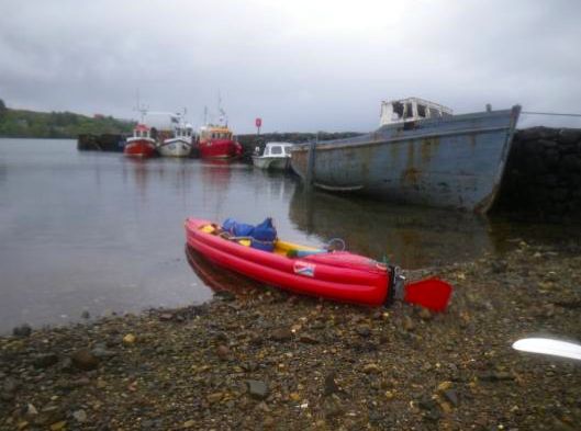
I left Plockton with the ebbing tide. Some WNW breeze picked up and I stopped on the lee of An Dubh-aird to put on my cag. The wind died an hour later and it was dead calm when I passed through the Black Islands, disturbing the seals basking lazily on the rocks. I came around the north of Eilan Ban and let the current take me under the bridge into Otter’s Pond. I landed in front of the backpackers hostel. This was the end of my paddling along the SSKT for this year. All I had to do now was to return to my car in Tayinloan.
Back to Tayinloan
I had to arrange my stuff in a strict packing set up to be compatible with bus traveling. I had a very large dry-bag for the kayak, PFD, paddling suit, pump, bailer, sponge, leashes, painter, compass. The paddles were secured to the bag with a pair of bungees and the blades wrapped into the folded seat pad for protection. The Ortlieb Rackpack bag contained the remaining food for about one week and small items like stove, pots, first aid kit, etc. Those two bulkier and heavier bags would go in the hold of the bus, while I would keep in the cabin the lighter and smaller Ortlieb Explorer which contained tent, sleeping pad, sleeping bag, some spare clothes and some snacks for the day. I could only walk a short distance with the large pack on my back and one of the other bags in each hand. It would have been easier with a cart.
The bus left reasonably early from Kyleakin. The road run alongside Loch Alsh then Loch Duich past the famous Eilean Donan castle. I had forgotten I wanted to go there by kayak.
The road to Fort William run through the dramatic Glen Shiel, then along Loch Lochy’s stupendous countryside. From my elevated seat I had perfect sights on both sides of the road and I enjoyed every minute of the trip, although it was raining and the mountains were hidden in low clouds. Unexpectedly the bus to Oban was due to leave Fort William much earlier than I thought and I had no time to visit the outdoor gear shop nearby.
In Oban the sun came out while I was waiting for the coach to Lochgilphead. Late in the afternoon the third bus dropped me at the entrance of the road to Point Sand, just in front of the deserted village school. A young couple got off the bus with their baby girl. They had no more luggage than a wheeled suitcase, a duffel bag and a stroller. They said they were going to the Point Sand campground too, so I proposed to go get my car alone while they would wait for me to pick them up. But they declined and declared they could walk with me. So be it. I hid my heaviest bag behind the low wall enclosing the schoolyard and set off to Point Sand with my three companions. Rebecca, the camp owner, was glad to see me back alive and handed me my car keys. I went to my car, started up and headed home.
Grabner H2 report • Geo-tagged photos • Map • May 2011 stage
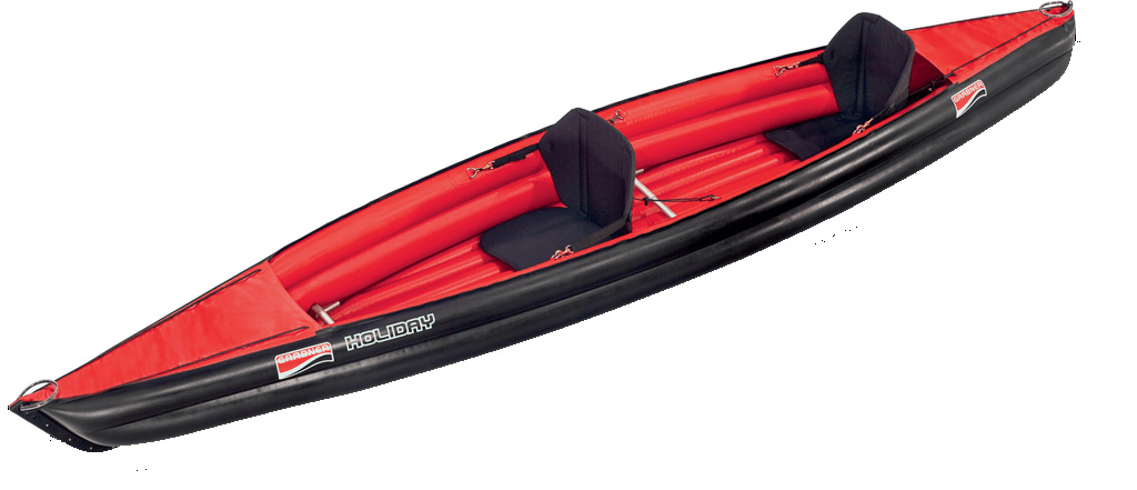
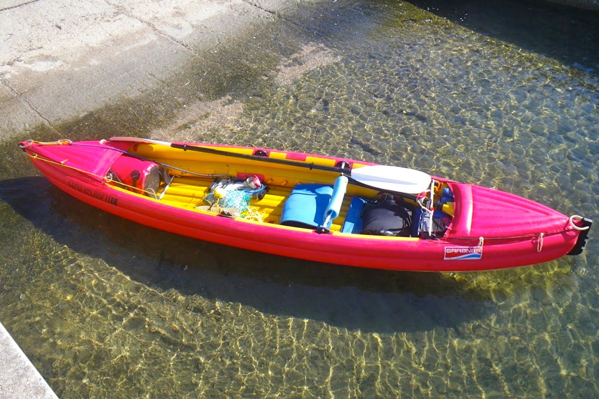
Grabner H2 inflatable kayak
by Gaël Auffret
Scottish Sea Kayak Trail Report • Map of SSKT • Grabner overhaul • In Sardinia
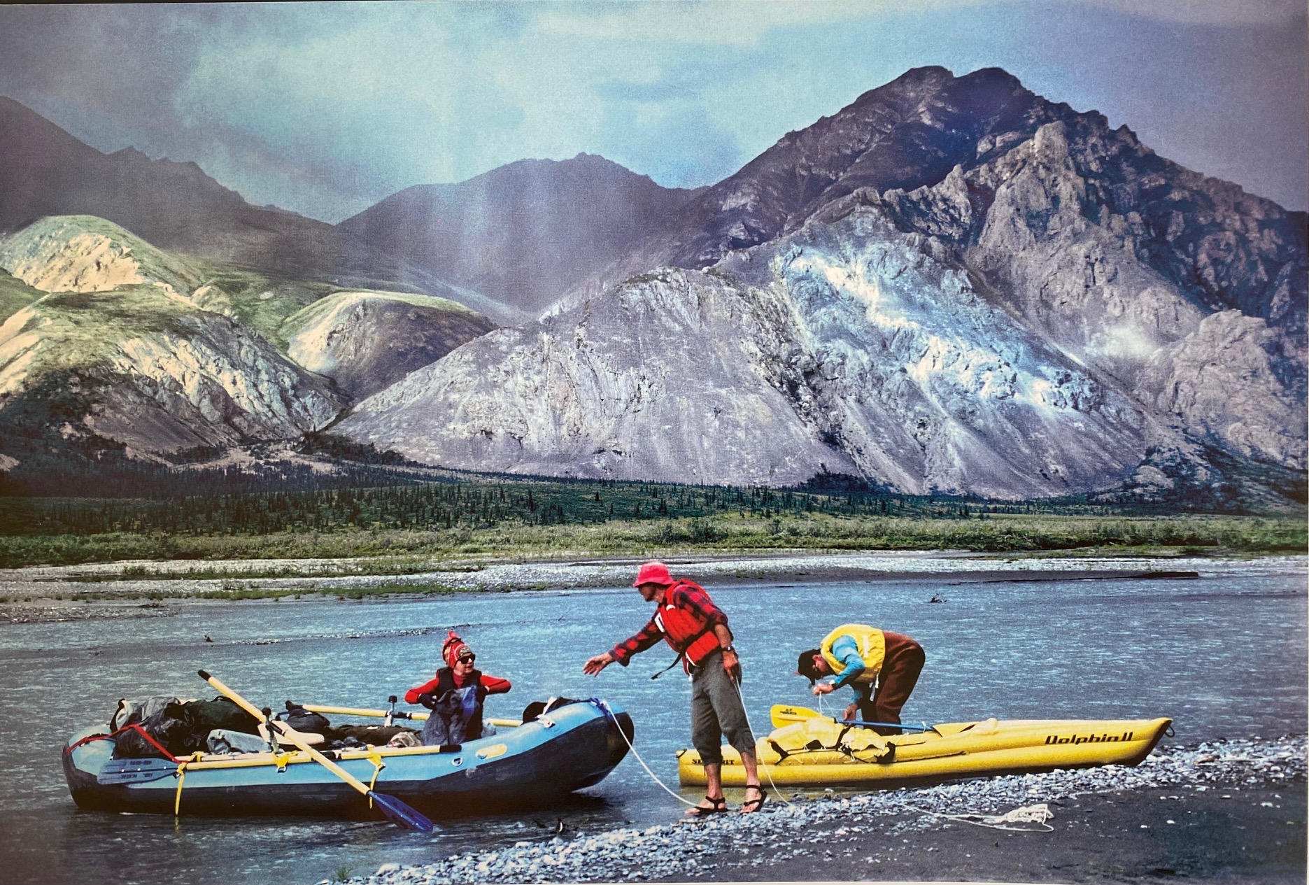
When I decided to buy an IK back in 1998 there were not as many models available as today. And information about inflatables was very scarce. I intended to make multi-day trips with this boat, but the only paddler I had heard of doing so was the late Audrey Sutherland. In a Sea Kayaker magazine article she mentioned she paddled a 13-foot Semperit Forelle III for extended trips in Alaska. I wanted the same boat because it was obviously proven as a durable expedition craft by her many summer trips done there.

Doing some research on the Internet I also found a very convincing article by Marge Nichols. We got in touch by e-mail and she gave me valuable information about her Grabner Holiday, almost identical to the Forelle, but now manufactured by Grabner. The good news was that Grabner was a European company and they had a reseller in Paris so I could have a look at the boat before ordering one.

I wanted a boat that I could use for multi-day solo trips, and day trips in tandem with my wife, or for taking the kids around. The boat would be paddled mostly on the sea, wherever we would take it during our vacations. It would be transported by car, bus, train or plane. As we are living in an apartment in Paris, it would be stored in our small basement unit.

The boat itself is very well made and the material is very sturdy. It doesn’t take long to inflate up to 0.3 bars (4.5 psi); less time than installing the rudder. The aluminum tubes used for backrests look like crap compared to the hull, the rudder pedals or the rudder head. The plastic part of the backrest is attached with tiny screws that did not last long and I soon replaced them with bigger screws. The wooden rudder blade is tough but not very hydrodynamically profiled. I use the rudder in a following sea (backwind) to go straight, or in beam [side] winds as the rudder helps control drifting leeward.

Compared to my rigid sea kayak the H2 is a good 30% slower. But the main performance difference is that the H2 cannot be accelerated beyond 3 knots (3.4mph), while I can boost my rigid kayak beyond 5 knots (5.7mph) for a while if need be. In a following sea the H2 doesn’t surf without a steep wave. Paddling against a short wind-induced chop is a trudge as you can’t control it with hips and knees as in a SinK, it bobs like a cork on the waves, which is annoying if it lasts a few hours.
The 3.95 metre H2 floats high on the water. Even though this means more windage, it also means less water splashing in. It does take water so I always sit in a pond, but not to the point I need to bail, except after some hours being beaten by a rough chop. I was sometimes swamped by some dumping waves when paddling inside the impact zone along exposed shores but the boat didn’t sink and was still manoeuvrable. I just had to escape the impact zone then bail the cockpit.

Being 75 cm (29.5″) wide the H2 is very stable, even more when loaded down with gear, and I never felt I was on the verge of capsizing. Just in case I did some capsizing/re-entry exercises in deep water. It’s easier to get back on board using a looped rope hanging from the boat.
The H2 is short and highly manoeuvrable. It turns on itself with a few paddle strokes. Draw strokes work very well and there is no need to edge it on its chine to make a sharp turn as with a hard shell sea kayak. This makes exploring caves and rock gardens easy.
There are plenty of useless footrest adjustment fittings in the cockpit (left) and none for attaching gear. I bought some D-ring fittings from Grabner and glued them in the front on each inside of the bottom tubes. Drybags are maintained by shock cord and secured by a leash. In order to push the cylindrical bag further in the front, I deflate the deck. The dry bags buoyancy is enough to compensate for the loss of the front deck buoyancy.
When I stop on the shore while the tide is ebbing, if I don’t want the boat to be grounded by the receding water, I install a mooring fore and aft. For achieving this I use two painters and a netbag (made of a piece of fishing net found while beachcombing). I fill the netbag with pebbles and secure it to the aft painter. I put the bag on the rear deck so that it falls in the water if I shake the boat. The fore painter is attached to a rock or a tree on the shore. I push the boat off. When the front painter pulls the boat back, the bag falls in the water and anchors the boat. When I want to get the boat back, I just pull on the front painter and the boat comes dragging the pebble bag. Then I haul in the bag with the aft painter, remove the pebbles, tidy the painters and we’re done. When the wind is offshore I just need the fore painter.
Paddles I carry two identical two-piece paddles (one spare), 230cm long with narrow grp blades, Lendal GRP shaft made by Plasmor, #1 sea kayak manufacturer in France. When traveling by plane, I carry a Lendal Kinetic 4-piece split paddle. I use shorter paddles, 218cm, with my regular rigid sea kayaks. But the width and height of the sides of the H2 require longer paddles for reaching water.

