A few shots from our first visit to the Summer Isles in 2006 with my original Gumotex Sunny and Mk1 Safari and when it seems the weather was unusually good for August. One day we paddled out as far as Tanera Mor and Tanera Beg, as well as Achnahaird and Loch Sionascaig and Osgaig and thought it was all a huge adventure.
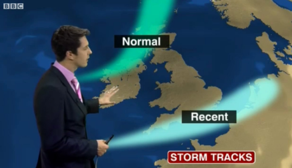
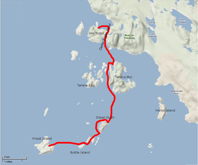
In 2011 I met Gael after he ran out of time and weather to complete the second stage of the Scottish Sea Kayak Trail he started in 2010 in his Grabner H2. According to the guy who wrote the guidebook, the SSKT is a 500-km run through the Inner Hebrides from the Isle of Gigha off the Kintyre peninsula to the Summer Isles, but with no shoreside infrastructure as such, most just follow their nose with the book’s help. In 2012 Gael returned to Skye for another go, now in the ex-demo Incept K40 be picked up from Sea Kayak Oban. In March that year Scotland experienced some very fine weather while England got the converse – a result of a misplaced jet stream (right). And so it was for Gael who managed a comparatively trouble-free run all the way to Ullapool where he rolled up his boat and bussed back to his car on Skye.
Day 1 – Kyleakin to Uags The trip began rather badly. I arrived around midnight in Kyleakin after an interminable drive from Paris with an exhausting final crossing through the Highlands mostly in the rain. I set up my tent quickly on the grass by the hostel’s backyard. Once in my sleeping bag, I fell asleep right away, lulled by the pounding of rain on the canvas and the rustle of leaves in the wind gusts. Early next morning I woke up with my feet feeling cold and wet; during my deep slumber I’d pushed them under the edge of the tent. Fortunately, my sleeping bag fill is synthetic and the nylon shell water repellent enough and with relief I found it was still dry inside. The ground all around was drenched and I could now test the effectiveness of my new Seal Skinz socks. It was still raining, so I donned my foul weather gear right away before proceeding with the usual pre-launch routine (inflate kayak, rig the accessories, sort food and equipment before closing the bags). Like last year I went to Kyle of Lochalsh Police Station to report my departure, then to the Co-op to stock up on McEwans in case I got shipwrecked.
Early in the afternoon, after a quick snack, I launched in Otter Pond by the Skye bridge. A fresh easterly was blowing out of the Loch against the flowing tide, raising the inevitable chop. I crossed the channel towards Kyle, then let myself be blown under the Skye bridge, leaving Eilean Ban to port. I paddled to Erbusaig Bay through the relatively sheltered Black Islands but decided not to proceed directly to Uags under the current crosswinds. Instead, I hugged the coast upwind towards An Dubh Aird from which the crossing would be much shorter. After vain attempts to take a picture of the two little otters which turned around me, I left the lee of An Dubh Aird and rushed towards the south coast of the Applecross peninsula. Two-thirds of the distance into the crossing I bore away and took a direct course to Uags, pushed at speed down the wind blowing along the axis of Loch Carron. Sadly I couldn’t surf the best waves though because the stern was too heavy with the beer. I landed around 6pm in Uags, and moved into the empty bothy.
Once installed, I hung my tent and sleeping bag to dry, then I rewarded myself this interesting first step with a hot tea and a thick slice of chocolate cake. Outside rain was still pounding.
Day 2 – Uags to Red Point I woke up at dawn feeling numb as my old foam sleeping pad had been of little comfort on the floorboards. The temperature was 5°C; so much for this jet stream. I went out to stretch my body and surprised a little doe grazing in the meadow below the ruined Uags hamlet. It scampered away before I could fetch my camera (this is a double entrendre called ‘lacking reflex’). But – it had stopped raining, the air was clear and visibility was excellent. The snow-capped peaks of the Cuillins stood out beautifully against the sky (below left) but the chill air from the northeast soon sent me back inside.
Once on the way from Uags an unexpected SE tailwind pushed me gently toward Sgeir Shalash but the breeze then turned NE, as expected. In the protected lee of the shore I paddled on north without difficulty, up to Camusteel, but when I reached the mouth of Applecross Bay, I had to fight against the wind. It funneled unhindered along the valley, whipping up the waters and raising an uncomfortable chop, until I reached some shelter in the lee of Rubha na Guailne. From there the long way north to Loch Torridon seemed a never-ending trudge. The wind had picked up to the point of pushing me hard offshore whenever I got 50 meters from the shore. I kept hugging the coast, despite the uncomfortable chop and the occasional breakers, because the wind was shifting SE, thus pushing me northward. When I eventually passed Rubha na Fearna I found myself facing the wind blowing right out of the Loch.
Loch Torridon greeted me with one of its customary gusts of which I’d had the humiliating experience the year before. I took shelter as soon as I could in a tiny cove hidden behind a natural breakwater. I badly needed a feed. After a snack and some rest, I pushed off to cross the Loch. I paddled a mile inland to gain an upwind margin of safety then I headed north. Wedged into the seat, with my legs holding tight on the thigh straps and squeezing the footrest, I blithely crossed the choppy zone, kept an eye on the most threatening peaking waves and checked off some landmarks in transit which I used to control my leeward drift with the other eye while admiring the spectacular scenery of the mountains towering over Loch Torridon (yes, all at once).
I returned to quiet water in the lee of the north shore, laid the paddle across the boat and started bailing. My open decked Incept kayak had ridden well on the waves but had shipped a fair share of water which was now swashing in the bilge. I pulled ashore in the early evening on a beautiful beach near Red Point.
The ebbing tide had just retreated beyond the tombolo that connects Eilean Tioram islet to the mainland, thus forming a placid lagoon. Some cows and sheep were grazing in the dunes undulating behind the beach. I pitched my tent in a hollow, barely sheltered from the chill NE breeze and crashed out.
Day 3 – Red Point to Slaggan Bay The night had been cold but the clear morning sky made me hope for a warmer day. When I shoved off I didn’t know that I was about to enjoy one of the most beautiful days of my paddling life. Passing Red Point I noticed with satisfaction there was almost no swell. For once I wouldn’t be shaken by the rebounding waves and could explore the nooks and crannies of this craggy coast.
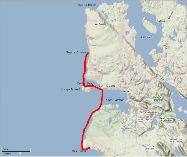
The sky became overcast and the NE wind picked up as I approached Loch Gairloch. The temperature dropped rapidly and I paddled more vigorously towards Carn Deag in an attempt to stay warm. I made a brief stop on the beach at Big Sand (left) but the chill breeze urged me on. I passed downwind along Longa Island with the hope of discovering a sheltered cove for lunch but found none. I then went on across Caol Beag, passed Rubha Ban and kept paddling north with my stomach gurgling. The beauty of the coast was worth the inconvenience of being cold, numb and hungry; huge sections of sandstone cliffs that had fallen in the sea provided an extraordinary maze of narrow passages that I enjoyed threading through. Erosion had also cut multiple geos and caves also worth exploring (I didn’t know what a geo was before reading the SSKT guidebook). I eventually reached Seana Chamas beach, largely uncovered by the outgoing tide and where I landed and dragged my kayak a few yards on a carpet of seaweed.
The sea was empty except for birds and a view that stretched westward to the Outer Hebrides. The Shiant Islands were clearly visible, standing out like a motionless line of battleships. I finished my lunch just as the tide returned up to my boat. The sky began clearing as I left and when I got past Melvaig all around me glistened under the sun.
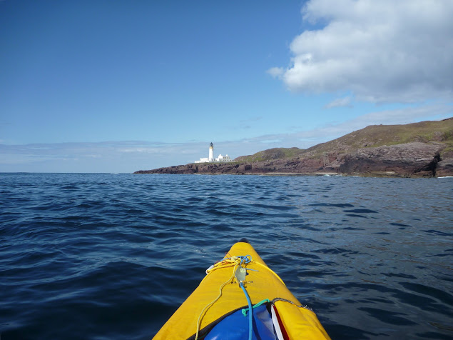
After half a mile of boulders the coast turned to sandstone crumbling cliffs again and I could resume prowling in and out of caves and geos under the bright light of this sunny afternoon. Quite suddenly behind another headland appeared – the dreaded Rubha Reidh and its striking white lighthouse. I felt the mid-tide current pick up as it dragged me over to the other side of the promontory. The whitecaps of a faster tide rip were visible out to sea but right under the lighthouse the sea was rippling gently against the reddish rocks. One of the most exposed stages on this route passed without event.
The NE wind that had been blowing since I left Kyleakin had dropped too, but there was still some swell from the north, preventing me from sneaking through the rocky labyrinth that stretched between Rubha Reidh and the beautiful beach of Camas Mor. Beyond Rubha Reid to the east the extraordinary snow-capped skyline of the Wester Ross mountain range rose from the horizon (left). Put in a trance by this sight, I carried on on an eastward course and arrived at Caolas an Fhuraidh. I took stock at the mouth of Loch Ewe before an exposed 4km crossing over to Slaggan Bay. To the SE lay Rubha nan Sasan still with it’s WWII bunkers and gun emplacements. At that time Loch Ewe had been the starting point for many Russia-bound convoys and a haven for Allied shipping. There’s still a NATO base there today. As I paddled to Ploc an t-Slagain I hoped I’d not be rammed by a nuclear submarine entering or leaving Loch Ewe; I’d read reports elsewhere in the Hebrides of these subs rising so fast the resulting wash tipped sea kayaks bow over stern. I reached Slaggan Bay at 7pm finding another perfect landing place, a crescent of fine sand surrounded by empty dunes.
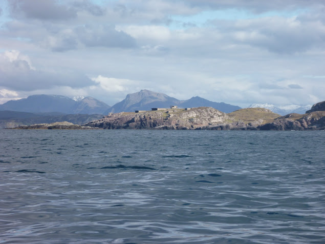
Day 4 – Slaggan Bay to Isle Ristol Under ideal paddling conditions I hugged the coast towards Greenstone Point, the last critical passage of the SSKT. The Point was flat and bare and proved even less dramatic than Rubha Reidh, although its rocky shoreline was wild and beautiful. From Greenstone I paddled on to Rubha Beag. In the distance the conspicuous peak of Ben Mor Coigach was towering over the horizon and to the NW lay a scattering of islets; the long-expected Summer Isles.
I headed towards the closest, Priest Island some 5km away. Halfway through the passage, the wind died off and the sea glassed over. The uncanny cries of the guillemots emphasized the eerie atmosphere; I felt like I was entering an unearthly space. From the SE tip of the Priest Island, I carried on around the west side. It was another paddling paradise with endless features to explore in the good company of seabirds and seals.
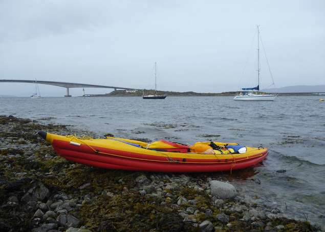
Once I completed this circumnavigation I paddled back to a cove called Acairseid Eilean a Chleirich (it’s quite a challenge to try to explain to other people the places I visited) where I pulled ashore onto a tiny uninviting boulder beach (left). As the afternoon progressed I uneventfully hopped through the convenient chain of islets lying between Priest Island and Tanera Mor, the biggest of the Summer Isles. I had intended to land near Althandu as I needed some of the facilities of the Port a Bhaigh campground, mostly their electrical hookups to charge the batteries, freshwater and even a shower, why not? There was also a pub close by.
But as I paddled through Old Dornie harbour I came within sight of the campground and within earshot too. The place looked packed and was definitely too noisy. After four days of solitude with no other sounds than the sea and the birds, I couldn’t stand it. So much for the camera, shower and a beer. I swung my boat south towards the lovely nearby beach of Traigh an t-Sean Bhaile on Ristol. I pitched my tent on thick grass which promised a comfortable night and the chilly cold kept any irksome midges from hatching.
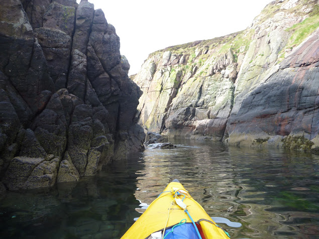
Day 5 – Exploring the Summer Isles I devoted this day to exploring the archipelago as all these islands offer the type of craggy shore most sea paddlers are looking for. The sea conditions were again at their best for squeezing through narrow channels between rocks, under arches or into caves with almost no swell and light winds. I proceeded anti-clockwise around Ristol, paddling along its west coast then circumnavigated Eilean Glas Mullagrach and Glas Leach Mor.
Shags had built their nests in the crevices of the cliffs overlooking the sea. They were not easy to spot as their colour merged with the cliff but their unmistakable angry squawks betrayed their presence above me whenever I got too close. From Glas Leach Mor (the ‘large green stone’ a good description actually) I crossed to Tanera Beag. Here I gave a wide berth to a skerry occupied by a large group of singing seals that I didn’t want to disturb. The haunting sound suited the scenery perfectly.
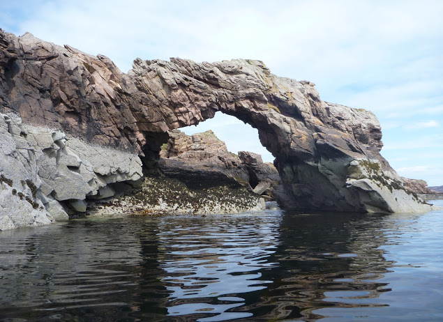
Tanera Beag is considered the most beautiful of the Summer Isles by the experts. Close to its SW corner is a cave deep enough for a tourist boat to get in and with a very high ceiling after which it’s called Cathedral Cave. Its SE corner is adorned with an elegant arch, which is another place of pilgrimage by all paddlers visiting the isles.
After completing the circumnavigation of Tanera Beag I pulled ashore for an overdue snack and a nap in a pretty little cove where the outgoing tide had left a broad sandy beach. Between Tanera Beag and Mor Eilean Fada I entered a kind of shallow lagoon of clear water. The tide was low and I saw my kayak’s shadow skip along the sandy bottom.
Later I landed in the Anchorage on Tanera Mor, a sheltered bay that opens to the east and filled with salmon pens. There is a floating dock for the tourist boat but the tea shop/post office where I’d intended to indulge in a brew and some piece of cake was closed. Tanera Mor (currently for sale) enjoys an offshore status which allows this tiny post office to issue its own stamps but no brew, no cake and no stamps for me today.
I hopped back in the boat and crossed the Anchorage diagonally and skirted Rubha Dubh, the east corner of the island. Here I entered a narrow cove choked with seaweed and backed with a pebble and boulder beach. High spring tides and gales had filled the depression beyond the beach thus forming a lovely pond, An Lochanach. I pulled ashore soon after two other kayakers. The guy didn’t look very happy to see me and curtly turned down my offer to help them to carry their heavily loaded sea kayaks. So I minded my own business, as I had just been advised to do. His wife came and offered remorsefully to give a hand, but I declined politely.
It had been a hot afternoon and I’d paddled without cag and without a cap for the first time in five days. But cold came back after 7pm and the Franco-Welsh relationships in the cove did not improve. Although our respective pitches were located 300 meters apart, each on one side of the beach, no invitation to share dinner was exchanged. It nice to be alone of course, but I like chatting with other paddlers too. Another time perhaps.
Day 6 – Tanera Mor to Ullapool On a beautiful sunny morning I headed SE towards Loch Broom and Ullapool. Sunny but cold, chilly indeed, so chilly that I had my breakfast in my sleeping bag.
In the meantime, the wind had shifted SE so I slogged against it all the way to Horse Island. I paddled through the tidal gap which divides this island from its northern tip, Meall nan Gabhar. Once through I pulled ashore and found a very convenient pitching spot. I regretted not having carried on to this place yesterday, instead of staying next to unsympathetic paddlers. So seemed to say the half-dozen seals romping about behind me. The sky was promising some fair weather that had been a long time coming. As the breeze didn’t abate I took shelter in the lee of Acheninver. But as soon as I got past Rubha Dubh Ard I fought the headwind again until I reached the base of Ben Mor Coigach.
Then I paddled below the sheer slope of the mountain until I got to what looked like the white sands of Camas Mor beach. Actually, it’s a pebble beach facing Isle Martin and the guidebook said amethysts can be found here, but I didn’t find any. By 2 o’clock clouds covered the sky and some chill air forced me back into my cold-weather gear.
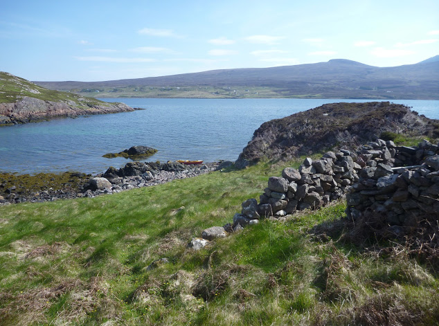
I shoved off shortly after lunch and enjoyed passing the last natural monuments of the Trail. I rounded Rubha Cadail, addressed the last salute to Ben Mor Coigach and entered Loch Broom. The wind unexpectedly veered NW and pushed me gently towards Ullapool.
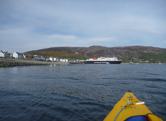
Once ashore I pitched my tent under the stares of some motorcyclists wondering where the hell I’d come from. A leather-clad fellow told me the owner was already gone and would return early next morning to collect the fee. Meanwhile, I washed the Incept to remove the grit scattered in the bilge, wiped it dry, deflated it, rolled it, and pushed it into my huge 160-l Ortlieb Kanurucksack. The K40 doesn’t fold as compactly as my good old hypalon H2 but I was relieved it crammed into the bag. I enjoyed dinner at the water’s edge overlooking at the now placid waters of Loch Broom, glowing in the satisfaction of my achievement. It has taken three years and two different boats, but I’d completed the SSKT in an inflatable sea kayak along with one of Europe’s most striking shorelines. Celebrations continued at the Ferry Boat Inn where I e-mailed friends and family, sipping some good beer, the sound of music replacing the soothing sound of the sea lapping the shore.
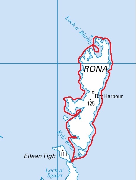
Ullapool to Kyleakin The weather was set to improve in the following days and I wondered whether to paddle north and round the Point of Stoer, take the ferry to Stornoway for a glimpse of the Outer Hebrides, or complete the exploration of Raasay and Rona that I’d started the year before. The first two options required maps that I was not sure to find in Ullapool. and I was also missing sailing directions.
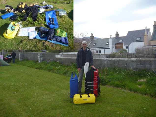
So I packed all my gear in my three-bag travelling arrangement: boat and paddling gear in the 160l Kanurucksack, camping gear and clothes in the 59l XPlorer bag, food, cooking gear, books, maps, tools and all the rest in the 49l Rackpack. The result was portable but heavy and I had a half mile walk to the bus station by the ferry terminal. Luckily the owner came by for the fee and gave me a lift. Soon we were en route to Inverness by bus; an alternative would have been leaving the bus at Garve railway station, halfway to Inverness and hopping on a train to Kyle of Lochalsh.
Eventually, I decided to park up in Kyleakin on Skye and undertook a very enjoyable three-day tour around Raasay and Rona. The year before I’d experienced the charms of these islands despite the unsettled weather – this time conditions were ideal. Back at the pier three days later, I was giving the Incept a wash on the slipway when a Land Rover towing a trailer full of sea kayaks turned in. A party of men got out of the truck, unloaded the kayaks and started putting paddling gear on. As they carried the boat to water they came over to say hello and asked about my boat and my trip. They were attending a kayak class beginning this very day. Their first-day program was a shakedown paddle in sheltered waters before a guided multi-day run to Sandaig. The guide joined the conversation and yet again I endured the usual hardsheller’s drivel about IKs. Ten minutes later I watched the student awkwardly clambering in their kayaks; for some of the clumsier it took quite a while. I told them they were lucky modern kayaks had such larger cockpit coamings – but not as big as mine! By the time I got to my car the temperature inside was like an oven, despite the screen I’d fixed over the windshield. My chocolate bars had melted. In northwest Scotland? Whatever next.
Sadly it looks like the amazing start to the summer may be over up here – or rather it’s back to normal. Since March it’s been one of the driest periods for years. June just gone was the driest ever while down south in places it was the wettest ever.
But the jet stream has flipped back into position and so it’s business as usual: the south is getting its overdue share of sunshine again while right now the wind howls periodically, it’s lashing down and I can barely see a mile across the bay.
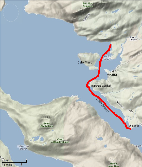
It was the same deal last weekend, but midweek the winds dropped and so did the pressure of finishing the current job. So I slipped out one evening across Badentarbet Bay to try and thread a loop through Horse Island. Not having paddled for weeks, as usual I went through the usual neuroses as I parted with the shore (“Crikey, this water really looks dark and deep”. “I really must take a spare paddle.” etc, etc…) while cautiously tracking some low cloud or mist coming up with a southern breeze. Horse Island is actually further than it looks, about 5km from the pier, and once I decided I’d survive the crossing I planned to slip through the gap between Meall nan Gabhar (see map, above) and head back. The passage is no longer pictured right by Gael who passed that way a couple of months back in his Incept at the culmination of his epic run up the Scottish Sea Kayak Trail.
As I rounded the corner and frightened some seals with a splash, it turned out Meall (a ‘hill or mound’) is a separate island only during the top half of the tide. On my arrival with the tide bottomed out, a bank of seaweed-covered boulders rose two metres out of the sea (below), creating a broad causeway between Meall and Horse. No matter, it made getting out easy and as a seal popped up and eyed my movements, I scrambled up the knee-high heather and scrub for a look around Horse, finding a broad grassy platform with various sheltered nooks for a sheltered camp. It’s said local farmers periodically drop off their sheep here to graze, but the only presence was the high-pitched caw of a large bird of prey hovering over its nest up on the hill. The clouds parted briefly to shine onto Ben Mor (above) and pleased with my offshore excursion, I powered back to the pier.
Normally on a decent weekend up here (as pictured left) there’ll be half a dozen vans with their distinctive kayak racks parked down at the beach. This weekend they’d all clearly read the forecast, but keen to get some hours in for an upcoming plan, kayaking chum Jon took a chance on the long drive up. The good thing with the lie of the land hereabouts is there’s usually somewhere sheltered to go wherever the wind’s coming from. Except perhaps during a northwesterly as predicted for Saturday and which bowls straight up the skirts of the prevailing lochs and valleys.
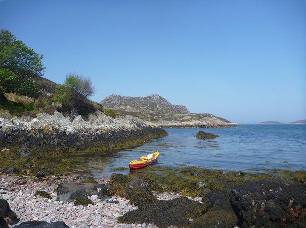
With it all laid out on my doorstep, Saturday afternoon we put in at sheltered Old Dornie harbour (left) and tried to head out round the adjacent isles, but I lost my nerve at the sight of the oncoming swell and increasing wind. Eager though we were, we reverted to Plan A, turned round as if on a tight rope and settled for a couple of hours solo re-entry practice, something I’d yet to try in my Incept K40.
Being a hardsheller, Jon works on his roll from time to time, but hasn’t quite got it nailed yet. He’s got a good alternative though, re-entry and roll, they call it – getting himself into the semi-submerged kayak on its side and then once in and braced, doing the hip flick and paddle float lift to get himself upright, at which point he pumps out the hatch compartment.
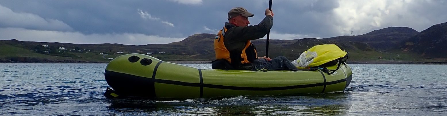
Me, I tried lunging onto the deck from the water, as I would on my former Sunny or my packraft. But the K40 bobs quite high when empty, so I was surprised I managed it, perhaps aided by the added buoyancy of my dry suit.
The problem is, once slumped belly down over the hatch (above), what next? You fall back in, that’s what next, because trying to turn onto your back tips you off long before you get your legs securely down the hatch. Perhaps with a bit more practice and finesse it could be done, but this was pretty calm water so realistically, just as on a hardshell sea kayak, it’s usually too tricky to pull off unaided. I then tried with my new paddle float as an outrigger. Would you believe it, re-entry was much easier and also pulls less water in as the boat remains more upright. Hook a leg over the floating paddle shaft and scuttle aboard. From this position I found it was fairly easy to flip round and drop bum first into the hatch and then stuff the legs in.
On that day I was carrying my two Watershed dry bags full of camping gear to see how it handled, so they helped reduce the boat’s possible swamped water volume, but even then any deckless IK conveniently self-drains when flipped back over – no awkward, X-rescue hauling over another kayak’s glossy fibreglass deck to drain. Once in the K40, there were only a few inches of water to bilge out, certainly not enough to cause sloshing instability (the true reason why you need to drain a kayak fast following a deepwater re-entry – not because you’ll get your pants wet). One thing I noticed was a rope knife attached to my pfd got caught on the hatch coaming, and also all this grovelling around over my wet kayak’s deck pulled the bite valve off my new CamelBak/pfd set up which then drained away. That will be £4.99 please. Now I know to reposition one and tuck in the other to avoid any snags. Spraydeck newsflash! The massively oversize cheapo spray deck I bought and modified (left) still required a lot of scrunching. But having actually used it, my feeling is the K40 sits so high it’s not going to be needed unless it gets cold or I’m heading for river rapids. At other times it’s just more clobber to carry around, wash and dry. Maybe I’ll get to see the value of it as my experience in the Incept extends. On a much lower sea kayak like Jon’s P&H, a deck is pretty essential.
The other way to get back into an Incept from deep water would be to simply unzip the decks and haul yourself on. No paddle float needed, although it occurred to me yet another use of the Watershed bags, particularly the smaller yellow Chattooga, could be as a paddle float (left). Any dry bag will do, but you know the Watershed’s won’t so much as seep a drop like a roll-top will after a few minutes, and the Chattooga even has some clips which can be used to secure a paddle blade.
If not using any type of outrigger float, a bit more water will swill into the K40 as you pull over the side to get back in. Ideally you then want to crawl up through the unzipped hatch hole as you got aboard, ease around and take your seat. But now you have the fairly tricky manoeuvre of trying to zip up the decks, all while hanging onto your paddle and not tipping back in. As I found first time out, without the support of another boat or a float, reaching the fully opened zip pulls on the Tasman is quite an unstable stretch from the seat, even with the grab loops I’ve tied to them. Longer loops might get in the way so some sort of a hook stick is needed if no one is around to do it for you. Regarding the K40’s zippy deck, as long as I wear a dry suit I can see even less need for it at sea in the conditions I’m every likely to go out in. Only on a WW 2 or 3 river would it be handy (with the spray deck) to save the boat swamping and the need to find a bank to drain it. If you’re paddling undecked, getting in from deep water all so much simpler, just like an SoT, and if not there’s a good section on the informative Kayarchy website illustrating all sorts of deep-water rescues.
Next day we set off to try and actually paddle somewhere, but off the beach it still looked horrible (left and right); 15-20mph winds but now from the SW. We paddled towards the Isles anyway, but after 15 minutes I didn’t like what I’d guess you’d call a boat-stalling ‘short chop’ which would only get worse further out. While hacking away warily, it occurred to me that focussed as you are in such conditions, it takes some effort to think of others or even keep track of them, and should they flip while you’re barely coping yourself, it can all go horribly Pete Tong. After all, no one usually capsizes is calm, wind-free conditions. That’s why we wanted to get some practice time together out here. The plan had been to go as far as camp the previous night, but the miserable weather and a fully fitted house just a mile away nixed that idea.
It wasn’t actually that gnarly, just not much fun and possibly about to get less so. As we did a U-ey I was encouraged to observe my Incept that morning felt less intimidating to turn than Jon’s slinky P&H. Again, no great surprise; his boat is floating stick insect with the turning circle of a stretched limo. The K40 is wide, has a rudder and – now that I’ve seen pics of me in it – the ends sit out of the water even with my weight and a 10-15 kilo load aboard. Is that a lot of ‘rocker’ or a little, I forget, but it turns easily with rudder + paddle strokes, and with the rudder up can spin on its axis with a lot fewer paddle strokes than Jon’s Scorpio. And with fewer edgy moments too. I was getting the feel for the Incept in rougher water.
So we sailed ourselves back to the beach, fighting to steer with the tailwind. Once there we settled for messing about closer to the shore, practising more turns out on the swell or paddling parallel to waves to gauge tippiness, secure in the fact that we were constantly getting blown inshore.
I was open deck that day, but noticed where the Sunny would have flexed and swamped over the rounded sides where I sat, the more rigid and higher-sided K40 stayed mostly dry. I was also conscious that even though they are also more clobber and something to catch your foot on, the thigh straps I’m waiting to glue in would surely help control in rough water. Either that or I see them as the only possible explanation for my lame kayaking skills! With the deck off we also tried paddling the Incept two-up – me sitting in the back facing backwards. That’s a total weight of at least 180kg in our gear, 20kg over what the Tasman is rated for. Jon reported the boat was tippier like this and had it been a serious requirement, I could have laid down to improve stability. One thing I noticed open deck is that there’s less back support from the low seat – a common problem with IKs using inflatable seats, and one reason I went for a Aire Cheetah seat on my Sunny. Clearly with the deck on the flexible coaming helps as a back rest and by the end of that day I felt the tops of my legs straining a bit in a bid to maintain upright. The problem is there is nothing solid to brace the feet against either, but I imagine this is another benefit of fitting thigh straps.
Having mastered many new skills, we had a quick scoot in the packraft (above); fun and very stable in the conditions, but also so slow you’d run out of puff before getting anywhere. The initial instinct in the chop was to try and jump it like a BMX bike; it sure would be fun to try surfing it on bigger waves one time.
Suddenly a glassy calm befell the bay, just as a private weather station near Ullapool recorded accurately in the graph on the right. Great we thought, let’s make a dash to the Tanera Mor about a mile and a half away, so we can say we got off the mainland – an ‘open water’ crossing! In this way many foolhardy newbs sail off to their doom, I suspect, because little did we know it was just the wind clearing its throat and refilling its lungs before coming back from new direction and harder than ever. But not before we’d managed to cross over and nudge the island’s sandstone cliffs (left) with our bows.
The previous day and that morning I’d been put off in similar- or even easier conditions but now, after a few hours playing around we were more tuned into our boats and even headed back diagonally across the stiff back wind and swell to make it a bit more difficult. Me of course with the aid of my rudder; without it I’d be correcting all over the place and need to stern-rudder, as Jon occasionally did. With backwind ruddering, I noticed it’s not a simple matter of holding the rudder at a certain angle because the tracking continually goes off, presumably as a quartering wave rises and drops behind you. A constant pedalling of the rudder controls was required to keep on the track. Don’t know if that’s normal, but I’d hate to wear out my rudder lines prematurely. So not a totally wasted weekend. Now we know we can get back into our boats alone one way or another, and can actually handle F4 conditions within sight of the shore, even if next time we go out, initially we may not feel that way.