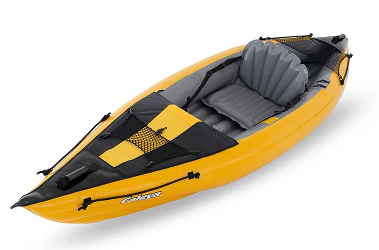
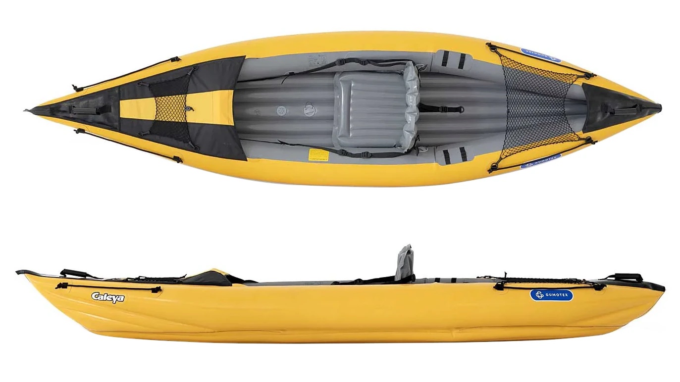
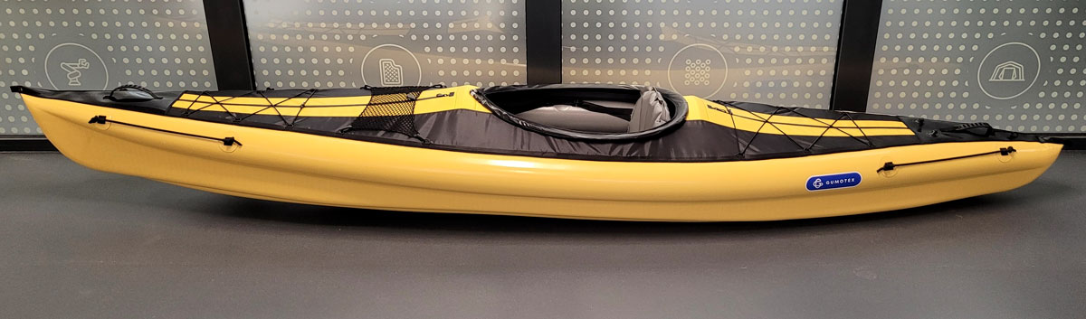
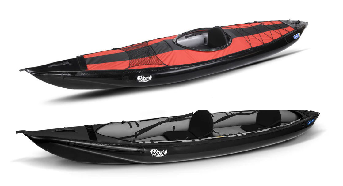
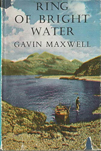
New for 2026 is the Gumotex Caleya singleseater kayak (left) which seems to fill the gap between the two ten-year-old Twist models. It’s 40cm shorter than a Twist 2 solo/double (below left), but 60cm longer than a dinky Twist 1. Up front you get a half deck which I find less useful than they look (you’ll still get wet) as well as an optional metal brace behind the seat. On other Gumotex boats like my old Seawave, these OTT and bulky metal braces support a removable spray deck, but they also add tension to the hull and push the sides apart to make it more rigid all round – probably. It’s also an admission that, without dropstitch flooring (as on the pricey Rush models), a tubed inflatable hull needs some help without raising pressures. Warranty claims apart, you wonder why Gumo don’t up the side chamber pressure rating to 0.25 bar and fit PRVs, then ditch the metal brace. I did the same to my old Seawave and I bet the Calaya can take it.
Twist 2Caleya
Longer is faster in the water, so the Caleya will be nippier than a 9-kilo Twist 1, but a Twist 2 is a lot longer again and can of course take one or two paddlers. So right now I don’t see the value in buying a new Calaya over a used Twist 2 for a couple of hundred quid. You do wonder if a 3.8-m Caleya 2 might be in the works.
It’s now mid summer 2026 but there’s still no mention on the Gumotex website or in their catalog of the decked, single seater Aurion, announced in September 2024 (video below). It does exist and is actually sold in this Czech outlets at around €2550 before discounts with the new 5-year warranty. I also see ‘B stock’ (seconds, with full warranty) going from €1750 in Austria). So the boat is available to buy, but Gumotex don’t mention it anywhere and it’s not listed in the UK. Odd.
Positive video reviews appeared in Europe in summer 2025, pre-production prototypes dished out to reliable influencers in strong Gumo markets, but there have been actual purchases too. Apart from above, currently most reviews seem to be videos in German, but we take what we can get here at IK&P. Normally I’d scoot over to Laurent Nicolet’s Rivieres Nature YT channel (French Gumotex importer) who has tried the new for 2026 Caleya. They’re paddle pros not influencers, who often got new Gumboats early and shoot great vids with minimal chat, showcasing everything from the Gumocatalog from white water to sea with no piece-to-camera exposition. But so far they’ve only filmed the revised but still door-wide Swing 1 (their pics below) and Swing 2 2025, though Laurent did announce the Aurion on the French IK forum in September 2024. The discussion did not progress much.
Swing 25Swing 25 – wide
One chatty German video from ‘RoGa‘ offers an AI-generated English translation – ‘adjustable fruit stand with push valve … for securing pastries‘. Good to know, but other segments make sense, and you get a good all-over view of the hull, inside and out, as you do on the garden vid below by Austrian? Kayak Kev. (translate ‘closed captions’ to know what’s being said). Another vid of his bottom of the page.
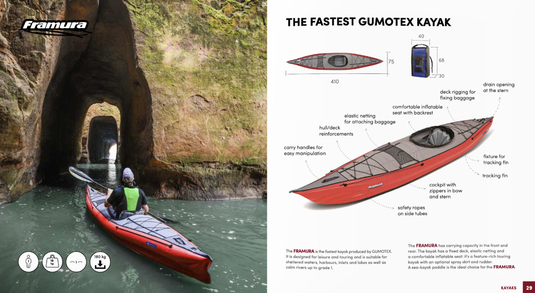
Anyway, the Aurion The Aurion (look it up) announces itself as the hybrid replacement for the possibly outgoing Framura (still discounted right now). So like the old Solar span off the DS-floor or ‘hybrid’ Thaya, and the Seawave begat the longer hybrid Seashine, so the Framura has cloned into the Aurion. The dims are near identical. The price is not.
The Framura was a boat which Gumotex always pitched as ‘the fastest Gumotex’. But as I wrote here back in 2014: I’m not convinced the 0.2 bar Framura is that much faster than a longer, stiffer Seawave [or later Rush 2]. And I also suspect it has not been such a sales success either. Perhaps claiming the former has something to do with the latter. Indeed I wonder if ‘fastest’ was nothing more than a marketing label for the Framura to separate it from the dumpier, also-decked Swings. Someone needs to do a drag race or time trial with all of them.
I-beam: parallel linked tubes, like an old lilo. This was the original way of making an inflatable ‘plank’ but was vulnerable to over-pressure and rupture if left in the sun (as happened to my Feathercraft). Automatic PRVs are a solution, but can be prone to leaks with grit-swill down on the floor. Lockable PRVs, like on my Zelgear Igla was another way round it, but for minimal weight gains, super rigid dropstich puts the whole issue to bed and turns out th light.
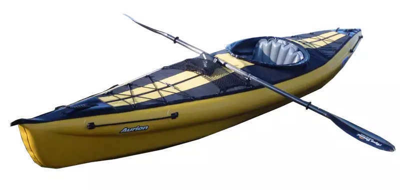
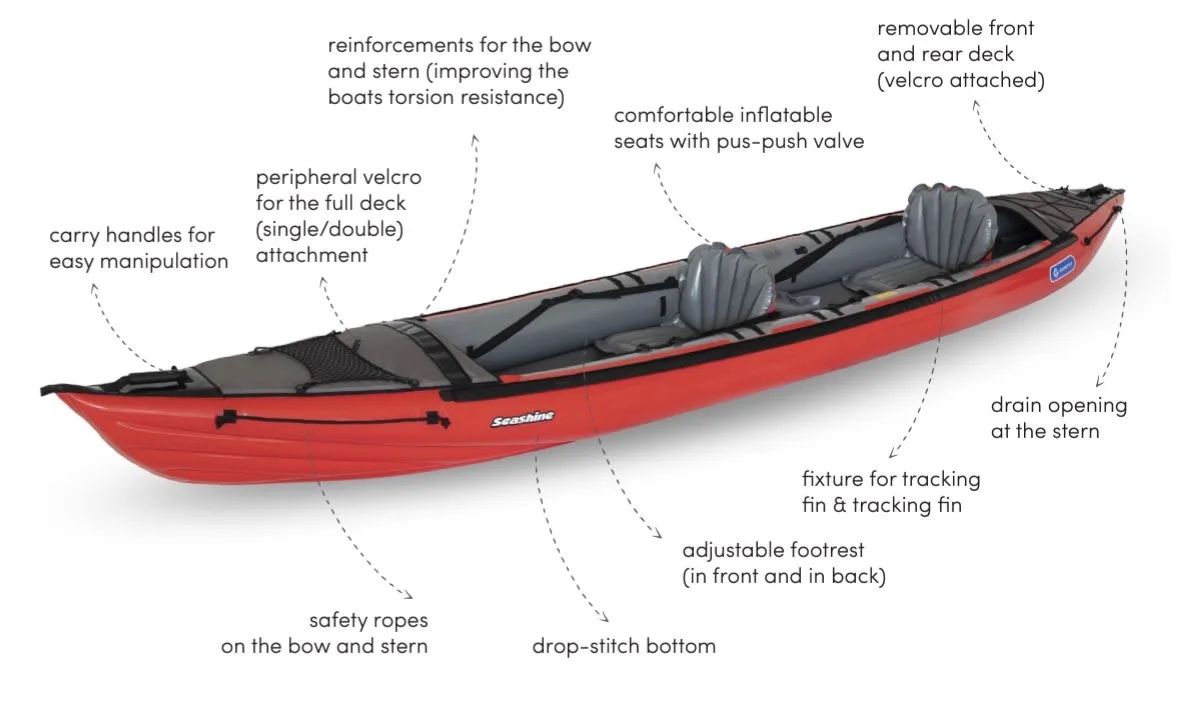
The new Aurion seems to match the Framuras LxW dims at 410cm by 75cm wide. This is actually only 3cm less than my 78cm Seawave (verified), no matter what the official dims claim. The Aurion’s payload is said to be 140kg. Oddly, the Framura retained old-school 0.2 bar all round; low-end Gumotex pressures. The new Aurion runs 0.5 bar (7.5psi) in the dropstitch floor, and 0.25 in the sides, while gaining a kilo (17kg, same as a Seawave) and ditching floor PRVs. That will be as rigid as a Grabner (who, fyi, manage stiffness and high pressures without DS). Only half a bar in a floor is nothing for dropstitch, and anyway, DS is much better at managing excess pressure (from blazing sunshine) than vulnerable, old school I-beams (like an air bed, see left). Along with less thick panels and of course rigidity for a negligible weight gain, this is the reason to incorporate DS in IK hulls.
Your Aurion’s DS elements aren’t just a slab of SUP board joined at the hip, like FDS IKs costing a third less, but complex hydrodynamic forms (like the X500) which partly helps explain the price. Like 2025’s Seashine, the narrow floor has a shallow V, but only on the front half (with protective strake), producing a keel effect which flattens out to the back where the skeg mount sits. They claim this narrow floor helps make the Aurion 10% faster than its predecessor. As someone observed, the Aurion may be 75cm wide at the sidetubes, but it’s much less at water level which should mean less drag for a better glide.
If you’re spending €2450 (around £2150) on a yellow Aurion from the few EU outlets which sell it, for what will be around the same £2500 with import taxes, in the UK (or anywhere) you can easily buy yourself Gumotex’s tandem Rush 2 with their optional solo or tandem removable deck. A Rush 2 is a bit longer, wider and lighter, and you’ll be able to paddle solo or double, with deck or no deck. Seems a more versatile option as long as you don’t mind the stealthy colour.
I haven’t visualised exactly how, but the single chamber (or linked) side tubes are said to be DS at water level, but regular round tubes above, but presumably running 0.25 bar which won’t strain the DS. In this way the upper non-DS side tubes act more like stability pontoons, and many testers report the Aurion may feel tippy initially, but has good secondary stability when leaning right over (or broaching along a wave) like a proper sea kayak. My Igla had the same overall dims and was perfectly stable to me.
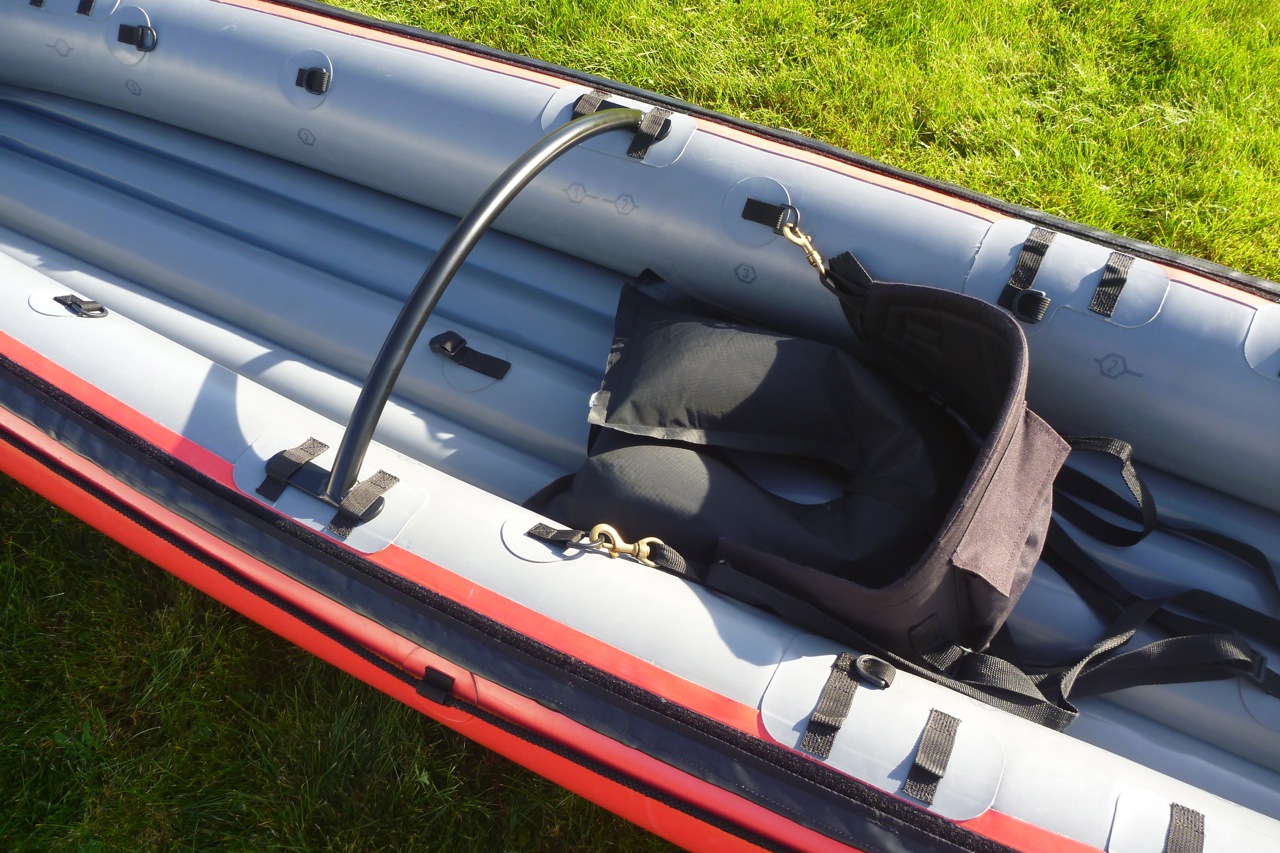
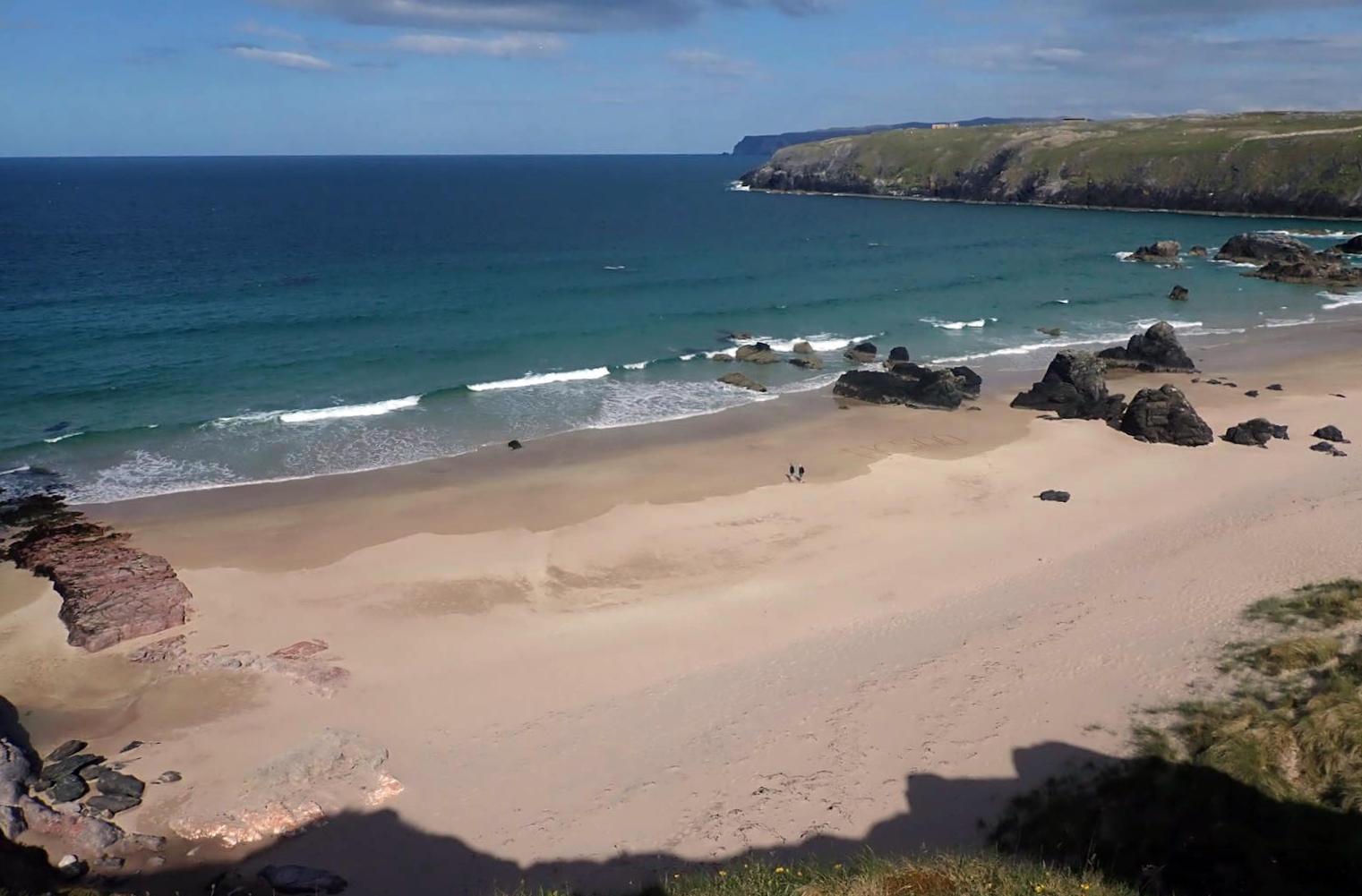
No one’s shown an out of the bag assembly yet, but the Aurion uses a pair of alloy supports fore and aft of the cockpit to keep the deck convex so water rolls ofF. The front bar can also give something to brace knees against, as I found on my Seawave (so no thigh straps needed) and supposedly, they tension the boat; holding the sides in as it flexes and opens out midway in heavy seas. You’d think the DS floor would see to that, and if these bars are anything like what my Seawave had (left), there’s a neater MYO option.
Drainpipe footrest – better
Meanwhile, the seats still look crude, heavy items made (I suspect) from Nitrilon off-cuts (unlike my Seawave adaption above left). They can easily be swapped out and so can the footrest. They insist on retaining a blow-up cushion, but at least it’s now adjusted by two straps running up to the cockpit. For tensioning, it’s a big improvement over the older, floor mounted set up, and you could easily replace the pillow with a piece of hard drainpipe, as I’ve done on my IKs for years (left). With a narrower than normal IK you’d definitely want thigh straps to steady yourself, unless the front deck support brace works. Combined with a proper footrest, it all makes a huge difference to connection and control or flat or lively water.
Some people become exorcised by the grab lines on the sides, but they’re just a safety requirement for inshore sea use in some markets, like France (where it’s currently not sold anyway). Talking of which, there’s also a rudder attachment hole on the back. Having experimented with rudders on my longer Seawave, it’s important to understand that on a kayak, rudders aren’t primarily about steering like on the QE2 liner; they’re more for compensating against crosswind drift on open water. With a rudder trimmed to one side you can paddle normally across a side wind and not have to haul hard on one arm to compensate. Very handy at sea, especially on overnight paddles where you may end up with winds you didn’t ask for.
Re-entering a decked boat from deep water. Needs practice and calm seas. Who ever capsizes in calm seas?
The cockpit takes a flexible coaming rod for a proper spray skirt, at which point you have to ask, would you want a fixed-deck single seater IK? You lose all the benefits of easy entry from or by the water, just to avoid a little paddle splash, though I admit a fore deck is handy for gadgets and snacks. Then you have the cleaning and drying issues, baggage loading complications and so on – all for what? In that way the similar but slightly longer and wider Rush 2 is 10% lighter, cheaper (though not once you buy the deck) and can take a second paddler which has proven benefits to well being and social bonding.
It’s good to see Gumotex leading the way with non-PVC hybrid IKs: first the basic Thaya slab, then the more sophisticated but initially troubled flat-floored Rush models, and the half V-hull Seashine which has been copied onto the Aurion, but with semi DS side tubes. Each iteration refines the Gumotex hybrid format, but unfortunately at a price that’s unlikely to see it chart in the UK or many other markets.
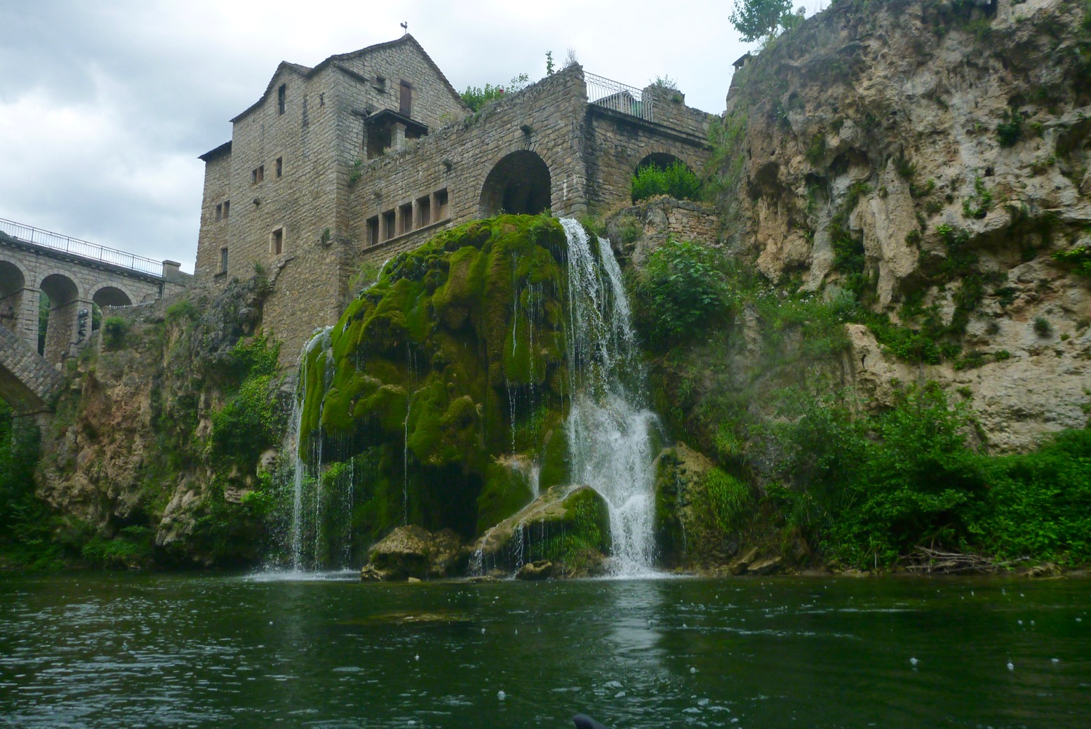
Thanks to Marcin for alerting me to the long-awaited dropstitch floor (DSF, or ‘hybrid’) Seawave. It’s called Seashine, an S-link between the old Sunny, Solar and Seawave? Why not. Length is 4.7m or nearly 15.5 feet with 83cm width. That’s 20cm longer and 5cm wider than mt verified Seawave, or nearly the same width as a Rush 2. Weight is said to be 19 kilos; 2kg more than Seawave, with the price in 2025, a hefty €2450. I really liked my hybrid, 4.15-m Zelgear Igla (with a removable DS floor) which was half a metre shorter and 10cm narrower (thanks to twin- or stacked sidetubes). A 15+ foot IK is a lot of boat for solo paddlers; it must be pitched at families or a fast and spacious sea tandem.
This is Gumotex’s third DSF IK, starting with the, simple, flat-floored Thaya (basically a hybrid Solar, which they still sell for around €400 less) and the lighter Rush 1 and 2 which was a new model in 2020 and had a more convoluted DS hull. The new Seashine resembles an elongated and wider Seawave, but without the Rush’s hydro-formed and more complex DS bow and stern. Underneath there’s a shallow V-shaped DS floor, changing to flat profile at the end, just like a hardshell sea kayak and the new Aurion. They’ve done a good job of smoothly integrating the DSF into the regular but lengthened Seawave, although in this two-up video you can still see the hull flexing in choppy seas, just like a regular Seawave would. As someone observed, a boat this long might well benefit from a rudder. There’s a kit you can buy.You wonder if the V floor might make the Seashine a bit more tippy, but tbh the Seawave had stability to spare.
I-beam floor: can’t do high pressures
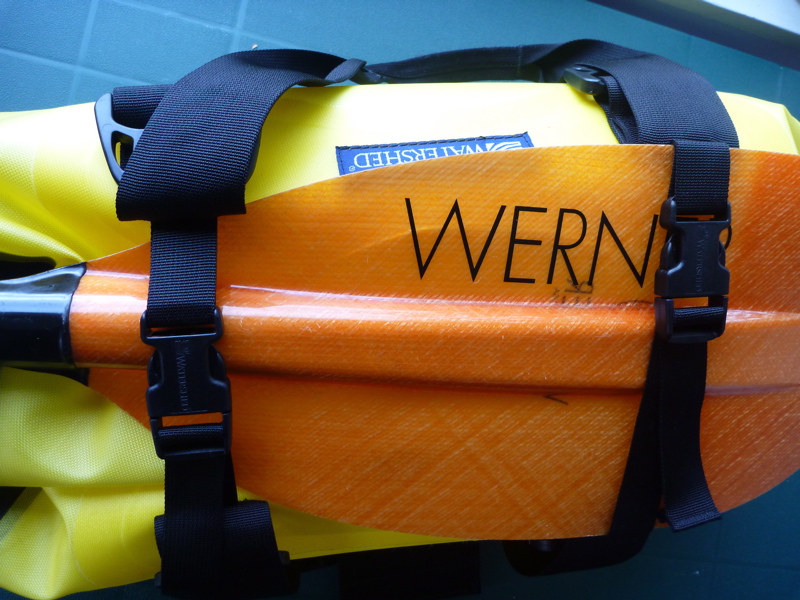
The Seawave was a great IK. I had two and improved one with higher rated side tube PRVs to gain stiffness. It cost little and worked well. A DS floor is another way of doing the same and eliminates the traditionally fragile I-beam element (left; an old Semperit). What are the benefits of a V-profile DSF? Better tracking than a smooth, flat floor, I imagine, but on the flat Igla a skeg easily ensured that. Better speed along with the added length? You’d hope so. A sustained 8kph or 5mph ought to be possible on windless flatwater. The ability to edge turn like a hardshell? That doesn’t really work with IKs I’ve owned (or I’ve never had a need for that technique), but the Polish bloke’s video below seems to show edge turning (leaning to the right to turn left) and so does the Aurion I am told. Only a comparison alongside a Seawave as well as the 4.2-m Rush 2 would tell, but it’s got to be a bit faster than either.
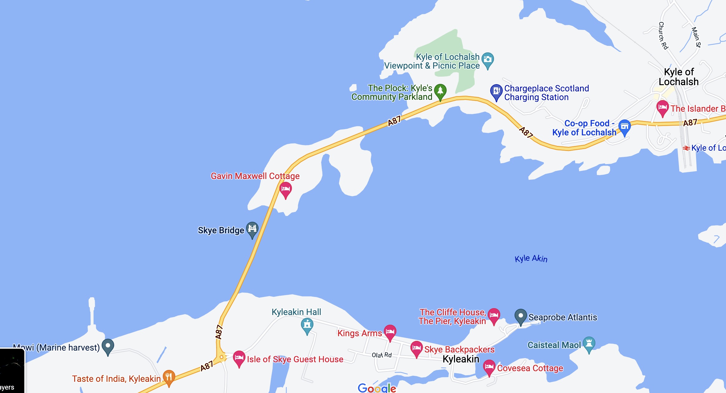
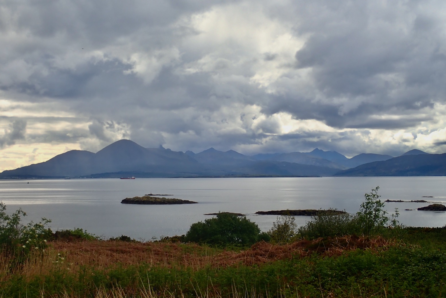
I remember plotting this IK excursion years ago. Set off with some wind and the tide from Kyle of Lochalsh by the Skye bridge, then wind among the skerries north and west into Loch Carron as far as Attadale station near the loch’s head. Once there, hop on a train 39 minutes back to Kyle. The line and single-carriage train comes down from Garve on the Inverness-Ullapool road before following the shore of Loch Carron with a couple of stations to Kyle where ferries served Skye before the bridge was built over the narrows in 1995.
Gumo gone
It’s over 100 miles from our place to Lochalsh but today everything lined up: a lull in the wind; a well-timed tide, and all subsidised by the delivery of my two-year-old Seawave 2 to its new owner at Kyleakin on Skye. I decided to sell my 4.5-m, 17-kilo Gumotex as I was becoming increasingly sure I could do most things in my new 2.8-m, 3.5-kilo Anfibio TXL, including paddling with the Mrs, packing or carrying multi-day loads and probably sailing too. I might lose some speed but could walk the boat to or from anywhere without difficulty.
The only midge in today’s ointment was Scotrail’s newly reduced timetable which now brought just two trains a day to the terminus at Kyle. We heard the 13.32 trundling past while on on the water; the other one was that evening after 8pm. No matter; we were in a packraft so decided to paddle 12km to Plockton – the more interesting part of the coast – then walk 8km back to Kyle along backroads.
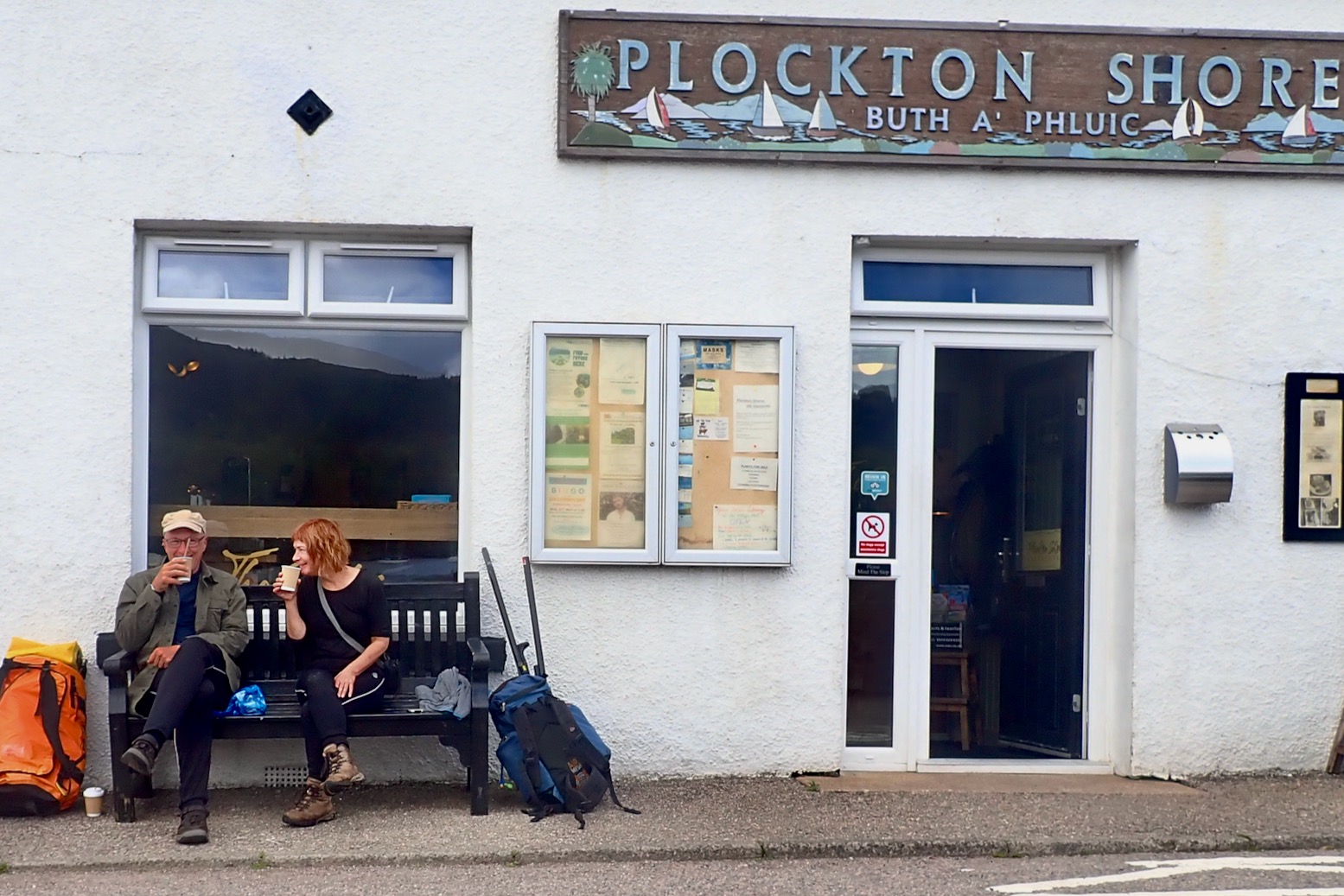
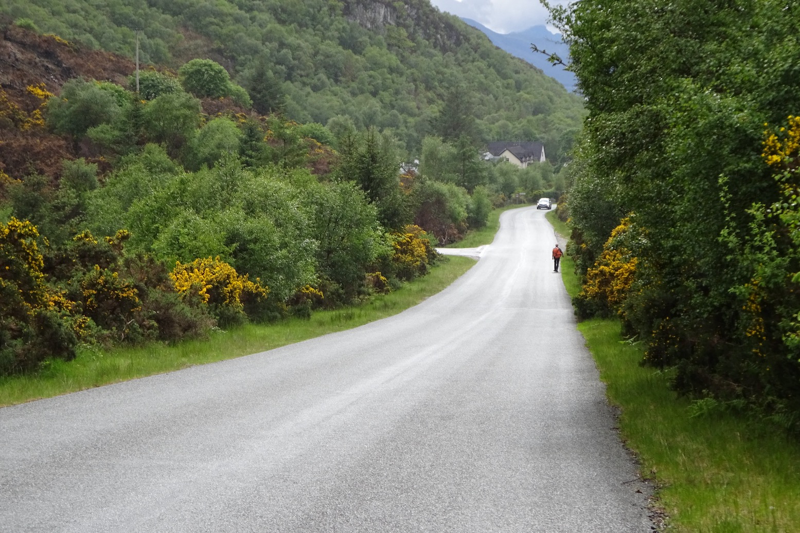
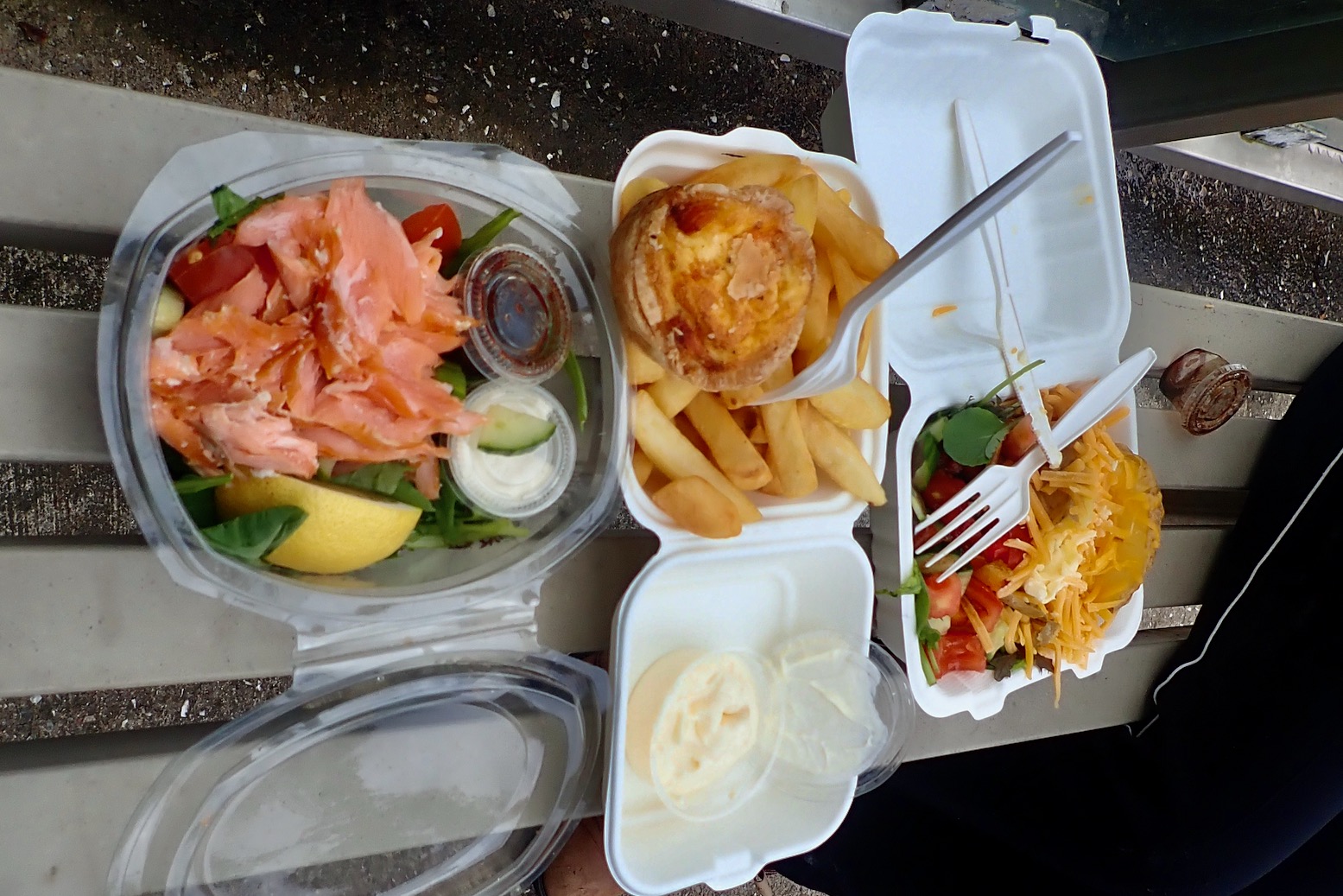
Seawave delivered, I admire the Plock of Kyle inlet, just a minute’s walk from a car park. Unfortunately this Footpath to the Shore appears to lead to the municipal sewage outlet.It’s nearly 8 miles so I try out the floor pad which ought to help the boat slip across the water. There is always something, and today’s Forgotten Item is the GPS. Shame, it would have been handy to weave among the isles more ambitiously. Instead we follow a less complicated seaward route, passing the outside of most islands.The floor doesn’t noticeably improve the glide and the boat skates a bit (rear skeg fitted). Worse still, with two in the boat the 10cm lift reduces interior space, end to end. And it isn’t helped by me giving the foam seatbase block one last try before consigning it to my private foam collection. After 45 minutes I can bear the agony no more and fit the inflatable seat instead. Much better, and it doesn’t wobble too much on the stiff floor, as it did on the Thames the other month.As we slip among the skerries we see a slinky otter. We are after all in Otter Country. Otterist, Gavin Maxwell lived just round the corner.His old cottage now props up the Skye bridgeThe cramped conditions provoke undisciplined outbursts from the crew.But actually we’re moving along fairly quickly and after 90 minutes are 5 miles in. Just 3 miles to go. I’m finding the hauling hard, though. Later I realise perhaps my large-bladed white-water Werner Corry paddle is ill-suited to tandem paddling. That’s almost IK speed if not IK comfort. I let the floor down and gain a couple of inches to stretch out the feet. Much better. I also try out my thigh braces which are OK; probably more effective for solo paddles.We turn towards the beach of Camas Dubh AirdAnd have lunchEven without a map you can tell it’s an isthmus. Sure enough it’s a 2-minute walk over a meadow to the other beach. Plockton village is actually less than a kilometre away, but round the headland is another 5km.As predicted, the wind picks up with the odd whitecap, but the TXL manages fine. We see some kayakers.The lighthouse on Eilean Chait marking the turn south into Plockton Bay.Annoyingly, I turn into the the wrong bay. I thought it didn’t look right.Never mind, it’s the edge of Plockton and pretty as a picture.Time to bag the boat…… and track down a coffee. It’s all a lot softer and twee round here, compared to the windswept, treeless Summer Isles.Double coffee while tourists shuffle purposelessly by.A chance to rest tired arms with a two-hour walk back to Kyle. How did that oil rig get there?It’s fun to pass through quaint villages at walking speed.And meet the hirsute locals.Full marks to Erbusaig for not going for grey pebble dash.Nearing Kyle. Look at all those trees!Unusual view of Skye bridge.The glowering mountains of Skye.Arrival in Kyle as the washes down our salty limbs.We find the Fisherman’s Kitchen down by Kyle harbour. Fifty Ways to Eat Your Salmon; just what was wanted!We tuck in in a bus shelter.A good day out. More like that please.
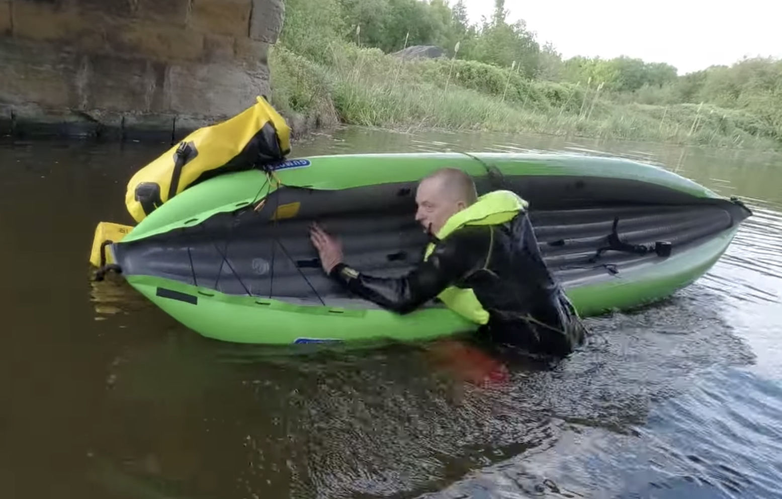
We can all chuckle about IK vlogger Karl’s repeated attempts in practicing re-entering his IKs from a deep canal, but it is definitely something you should try to master before heading out onto open water in a new boat. And note, this means deep water: ie, not being able to stand on the bottom.
Karl is practising in benign, controlled circumstances: calm water and conditions; mate and banks at arm’s reach, warm and buoyant wetsuit. Even so, you can see how the effort and cold water soon wears him down, even in a small canal. Falling out in deep water too far from the shore usually happens in rougher more intimidating conditions.
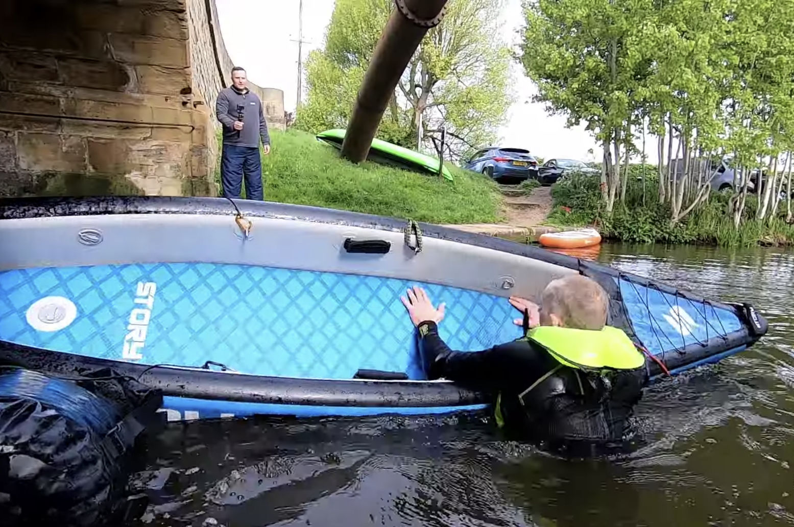
Re-entering a decked IK…… is darned tricky
In the video he tries two different IKs: his Gumotex Twist 2 and Story FDS – and reminds me of me when I was keen to learn new skills in my early years. I’m not at all surprised he found it impossible to re-enter the boxy, high-sided Story FDS. As I’ve seen done with hardshell sea kayaks, crawling up over the bow or stern can work, but good luck with that in choppy waters that just tipped you out.
One solution is a handily accessible paddle float: a blow up bag you slip and inflate over your paddle blade, a bit like water wings. This makes your paddle into a stable outrigger to remount the IK. With no float bag use a suitable drybag (left) or your pdf if desperate. This also needs practising if you’ve found you can’t re-enter you IK normally.
With his non-dropstitch Twist Karl nearly makes it. I found years ago in a similar Sunny that dipping down then launching up and over the side like a breaching salmon works, kicking hard as you go. You need that extra drive from your paddling legs to lift you up and over.
He notes his buoyant, wetsuit-clad legs get pulled under the boat. Too much buoyancy can make moving around difficult in the water. Lying flat on his front with legs behind and driving in from the side might work better. Swim in hard from the side and launch yourself across the boat like a Roman siege galleon. As with many athletic moves, once you get the knack it becomes easier because you know you’ve done it before. Of course, with someone else around to hold the far side of the boat or using their bow for added support, the whole drama becomes easier. In dodgy conditions not going out alone is the biggest lesson of all, but this is not always possible so we need to learn how to self rescue.
For reasons of topography and size, France, particularly the south and west, has some great paddling rivers. Mountainous areas not immediately adjacent to the sea produce long rivers along which you can choose the gradient and level of difficulty that suits your ability. And you can do so for days at a time. You can also add unfettered rights of way on the water, though that’s an unfortunate anomaly unique to England and Wales.
What they Say [translated] RIVIERES NATURE EN FRANCE answers all the following questions. For each route, you will find: • level of difficulty (easy to intermediate), the length and duration • specific regulations for the route • minimum, maximum and ideal water levels, and how to know them • access points with gps coordinates • QR codes to map access ponys and water level stations • description of the route (km by km, focus on difficulties) • short hikes off the river (canyons, caves, viewpoints, etc.) • specific safety advice • useful addresses (campsites, visits, service providers) • detailed map with an IGN topographic background
• Must be the ultimate guide to southern French rivers • The author has been there and paddled it – all bar three of the hundreds of photos are his • Very nice full page maps detailing portages and rapids • Parallel river summaries in German • More IK photos than you can point a paddle at • With a mobile signal, QR codes for put-ins go straight to your device’s map • Numerical waypoints also given • Nice paper and great value per gram • Printed in Belgium – better sustainability
• It’s in French – domage • The design can be a bit dense • Packrafts (and SUPs) not seriously considered
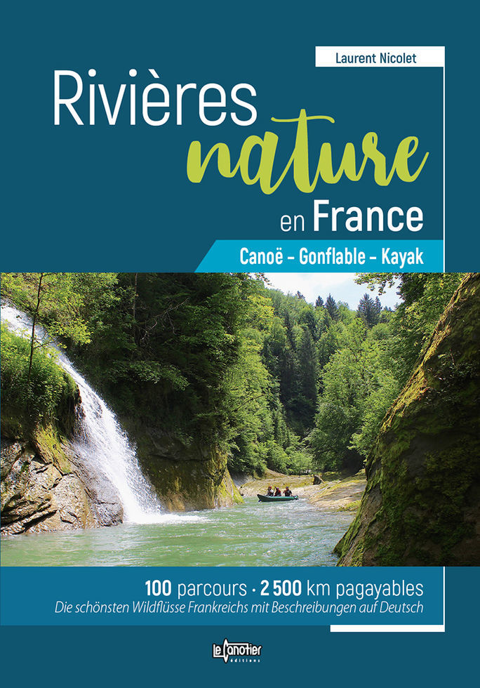
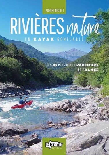
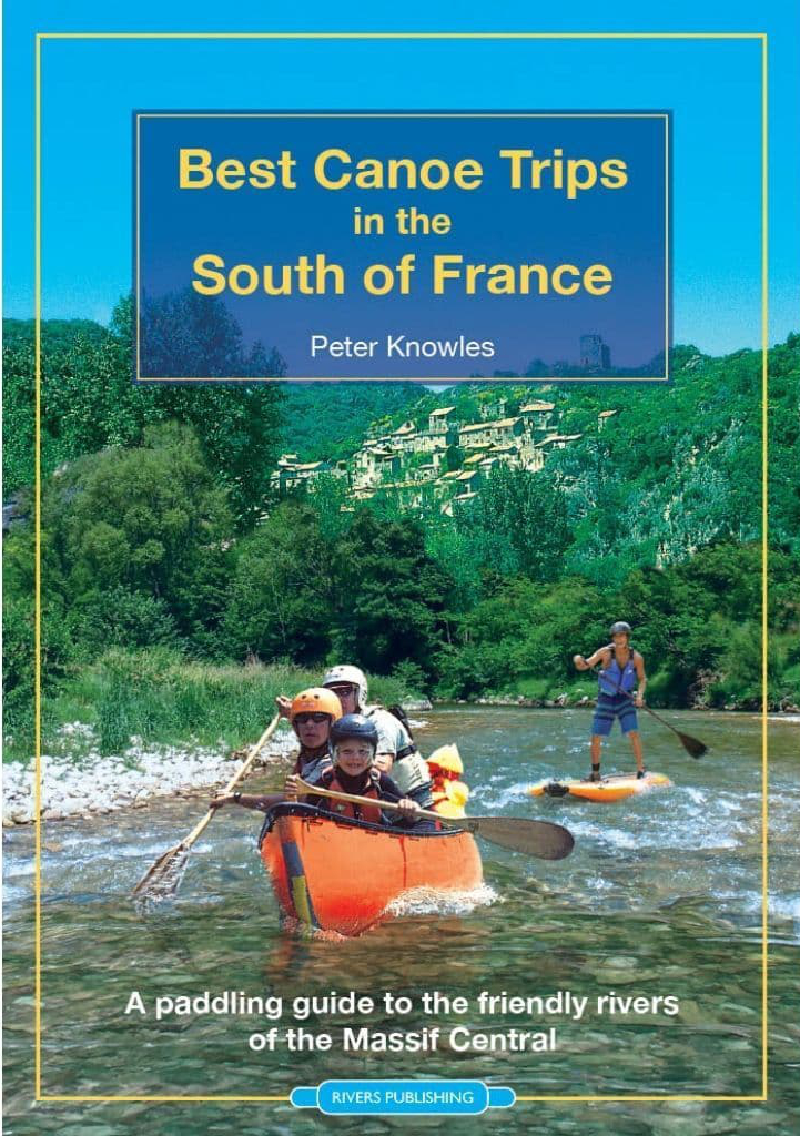
Review Rivières Nature en France is a similar if far more comprehensive title to the dozen rivers in Best Canoe Trips in the South of France (left) which I’ve used myself. This 416-page book compiled by Laurent Nicolet (distributer of Gumotex IKs and Nortik packrafts in France) lists no less than 100 routes over 63 rivers mostly in the south and west. It also shows parallel short summaries for each route in German and is sold on amazon UK for under £25. The book has more images of IKs than have probably ever been printed – even after my book came out ;-) This edition seems to supersede an earlier title published in 2018 called Rivières Nature en Kayak Gonflable which is Nicolet’s day job. For years he’s produced videos validating the utility of ‘kayak gonfables’ or KGs in French. It might well be the same or very similar book, but reprofiled away for IKs towards all paddle craft.
All the great rivers of the south are here: Tarn, Ardeche, Dordogne (ideal for beginners), Verdon and the sportier Allier, as well as a whole lot you’ve never heard of. Up front you get a location map (above), after which each river is listed alphabetically and described over a few pages. There’s the usual advice on what gear to take and safety tips like never tying yourself to the boat (SUP leashees take note) or shooting weirs without checking first. That’s unless there’s a portage-dodging passe canoës or canoe chute (left) – a common feature on French rivers which add greatly to the fun. There’s also an interesting rant against official censures against solo paddling “Imagine such restrictions on walking and skiing!’ Quite right, mon brave.
The author covers the full range of kayaks and canoes, hardshell or inflatable and even packrafts and SUPs (translated above). But less versatile SUPs and packrafts are virtually excluded from the book’s copious imagery, though a decked or bailing packraft could probably managed all the whitewater shown, and there must be some easier rivers which could be ‘boarded. On p379 I’m not sure the bloke balancing upright on some sort of dropstitch picnic table is on a SUP as we know it. There follows the usual advice on ‘leave no trace’ including using Le Poop Tube en sauvage, an explanation of Class 1-6, the vigicrues website for reading live river levels and which I discovered one time on the Allier, and advice on organising shuttles – all much eased if not eliminated outright by using portable packboats.
I won’t pretend to have read this book cover to cover, were that even possible – I speak French a lot less badly than I read it. But I only recently realised the ease at which a page can be translated with a translation app using a tablet or phone camera, or dropping an image into Google Translate. Reading a translated A4-sized page on a phone screen would be tiresome; easier to do back home on a desktop and print out. Some examples below. Note you have to excise the QR codes or Google goes there.
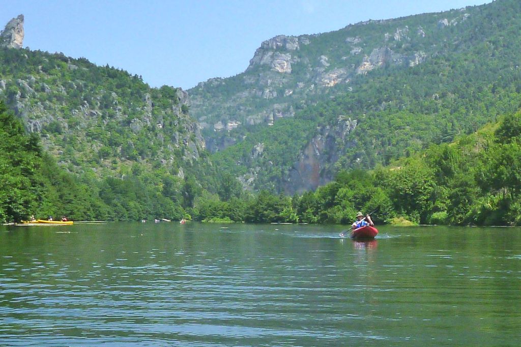
As a test example, I can concentrate on a river like the Tarn which I’ve done a couple of times both in a packraft and with IKs.
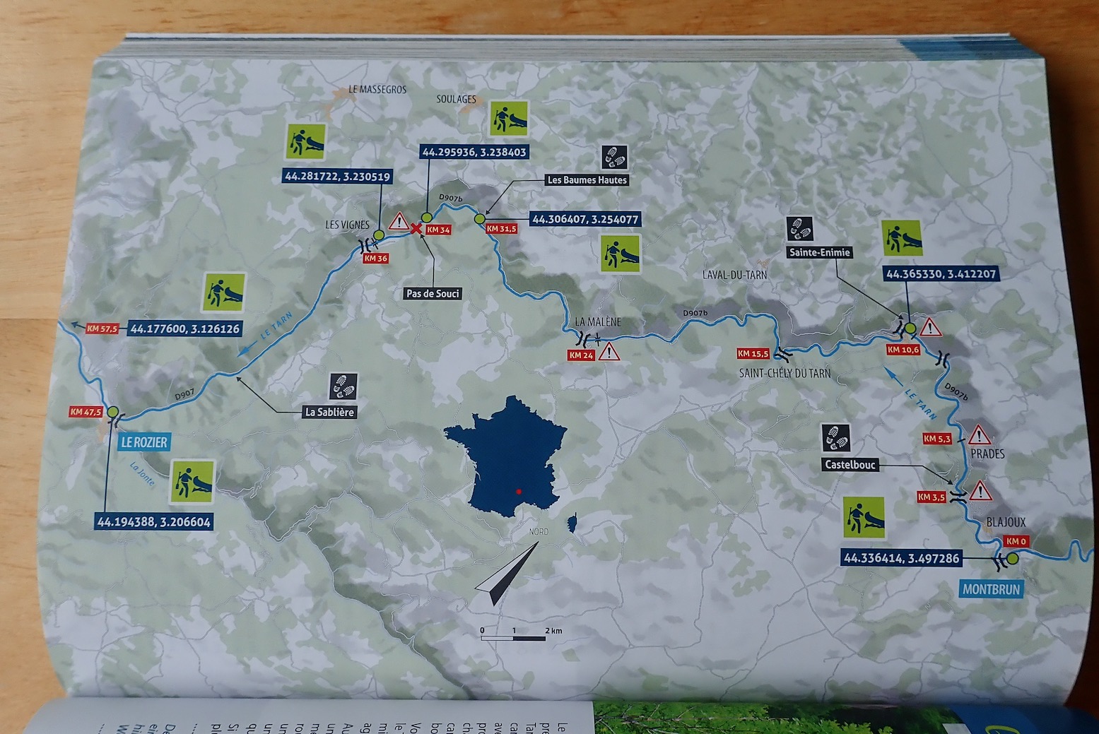
Tarn map. Fairly intuitive icons but no explanatory key and no campsites labelled.
Le Sabiliere – as hard as it gets on the Tarn
The Tarn description focuses on the most popular 57km section from Montbrun to Le Rozier. I have to say I made that 47km measured off Google Maps on my big Tarn map which covers the full 84km run from Florac, 18km upstream from Montbrun, to Millau, 19km after Le Rozier, Using public transport, I found both Florac and Millau better choices to start and end a Tarn packboat paddle. Anyway…
Tarn summary
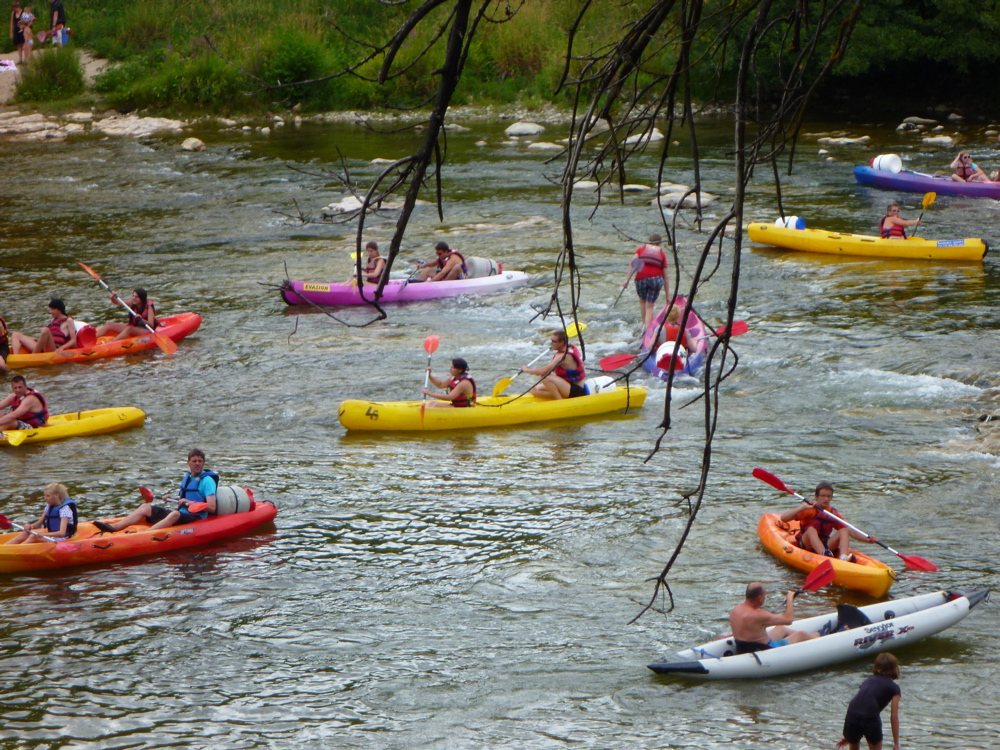
The first thing they advise is avoid the peak holiday period when the Tarn can become a logjam of hardshell rentals and yelping kids (left; actually the Ardeche below a busy campsite). While I’d certainly avoid the Tarn (and indeed France) in August, as a foreigner I found the occasional hullabaloo in July all part of the fun if you just paddle through it. Packed-out campsites along the stage described will be as bad as it gets. And they are packed out.
Tarn – Les Detroits
You then get a river summary: best time of year; regulations (if any); water levels with min, max and ideal levels, plus a QR code going direct to vigicrues – a good use of this idea; the best type of boat; environmental protection (if any); wilderness and tranquility; off-river pedestrian excursions, and where to sleep, but with only a selection of campsites including websites and a phone number. These could have been much more usefully added to each route’s map. Selected put-ins/take outs have more QRs linked to waypoints which are also printed in old-style DMS (44° 56′ 15.5″ N…), followed by the much less error-prone decimal-degrees (DD: 44.9376297, 2.321622…) format. Google still uses both but the sooner we all get used to simpler DD the better.
Kayaker caught putting-in below the Soucy rock-jumble by the Google drone
St Chely
Next is the main route description: KM0, KM22.7 and so on. ‘En aval‘ was a new expression on me: ‘downstream’. If your French is a bit ropey – or cordée – it would be worth translating page images in the planning stage, as suggested above, so you don’t find yourself in l’eau chaud. Doing so you’ll come to learn handy expressions like en aval and so on.
Tarn Route description
The book goes on like this, river after river, with enough photos to help you identify what looks appealing. It celebrates a newly opened passage of the Allier from Naussac all the way to Brioude (114km), though you may want to miss the initial 22km of “no less than 55 distinct rapids [up to Class 4]” which end at Chapeauroux.
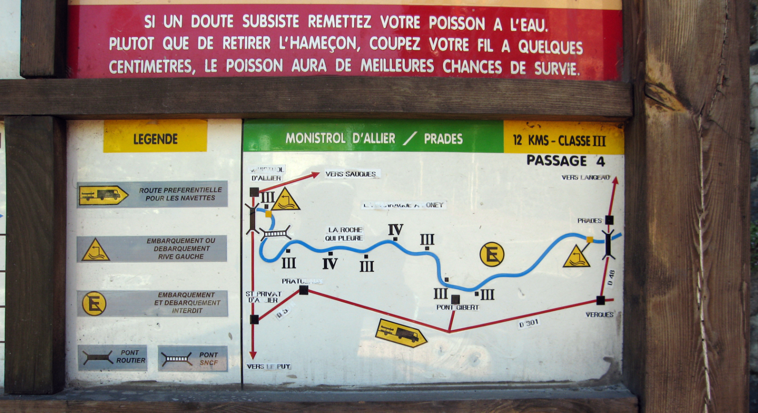
Coming up the train line from from Brioude, it was from Chapeauroux one June that I blundered rather naively down the Allier in my early Sunny days, after having found the Dordogne a bit of a doddle the previous year. As mentioned elsewhere, a dam up from Monistrol (30km below Chapeuroux) has by been rebuilt lowered to salmon-friendly levels so that the long taxi portage I had to do around the now non-existent reservoir from Alleyras is now just an awkward portage down the new dam face at Poutes. (At the back of the book is an article entitled: ‘Hydro-electricity; the least renewable of renewables’). For the 12km from Monistrol to Prades (above left) you’ll again want a deck or self-bailing boat, otherwise you’ll find yourself as I did, pulling over to pour the water out of your boat. From Prades it’s all a less fraught and as enjoyable two days to Brioude.
You can have a lot of fun with the English Rivers Publishing guidebook – in some ways I find the basic design and layout a bit less dense. But once you’ve seen it and done it all, Rivières Nature has many more paddling suggestions in the fabulous south of France.
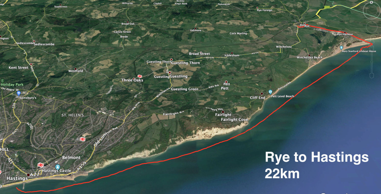
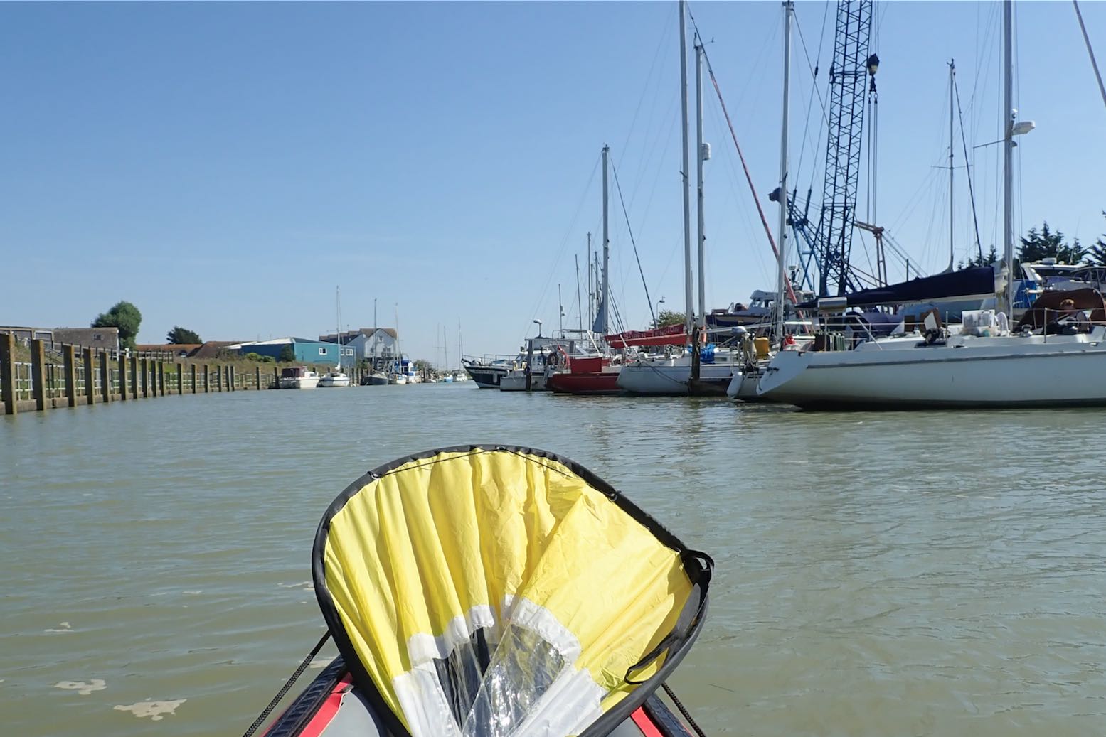
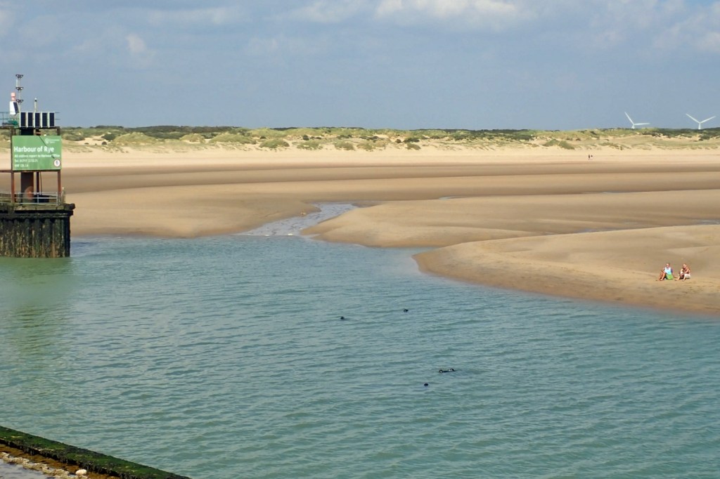
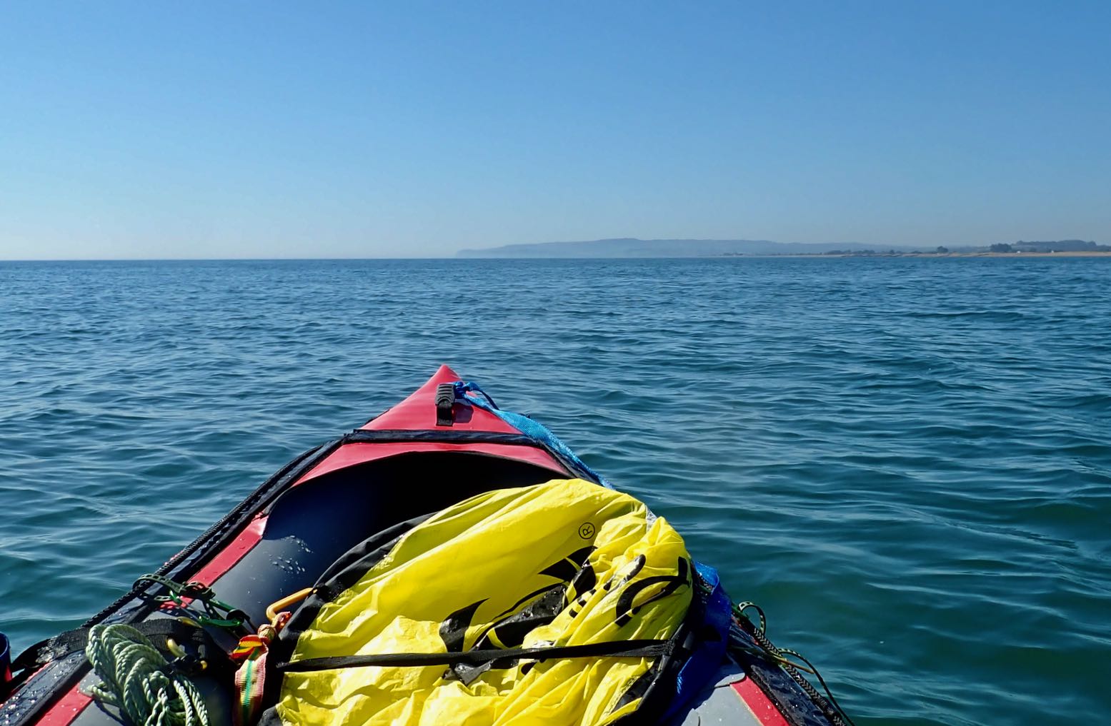
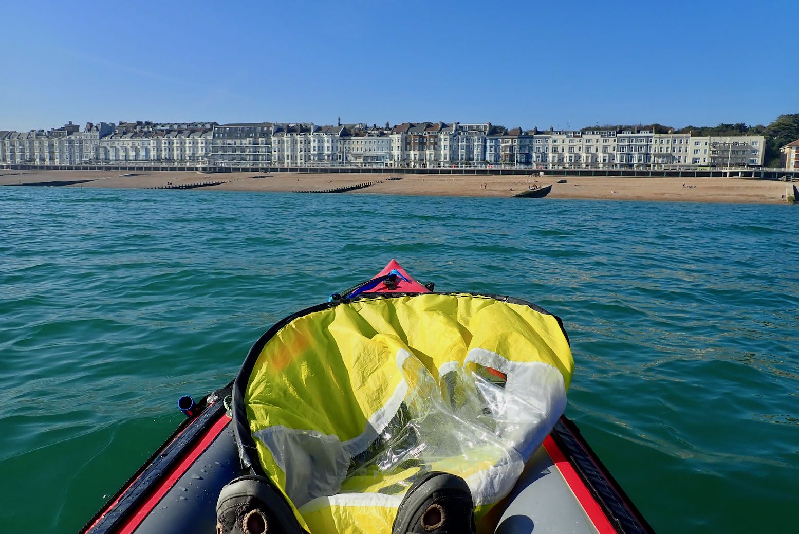
Once we were let out in the Covid summer of 2020, we did a very nice coastal walk from Hastings to Rye along the Sussex coast. Hot, but not so windy, it would have been just right for paddling. Today conditions were similar for a westbound transit from Rye back towards Hastings. High Water (and a spring tide too) was at a very reasonable noon in Rye, with a forecast of 8-14mph from the east and a bit of a kick at 3pm. I was hoping for the upper limit and a bit of splashy sport, so brought the WindPaddle I’d used on the packraft last month in Scotland in much stronger winds.
It’s only a 10-minute walk from Rye station to a boat ramp on the quay where the water was still inching up the concrete as I pumped up the Gumotex.
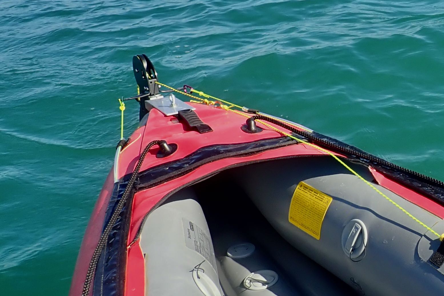
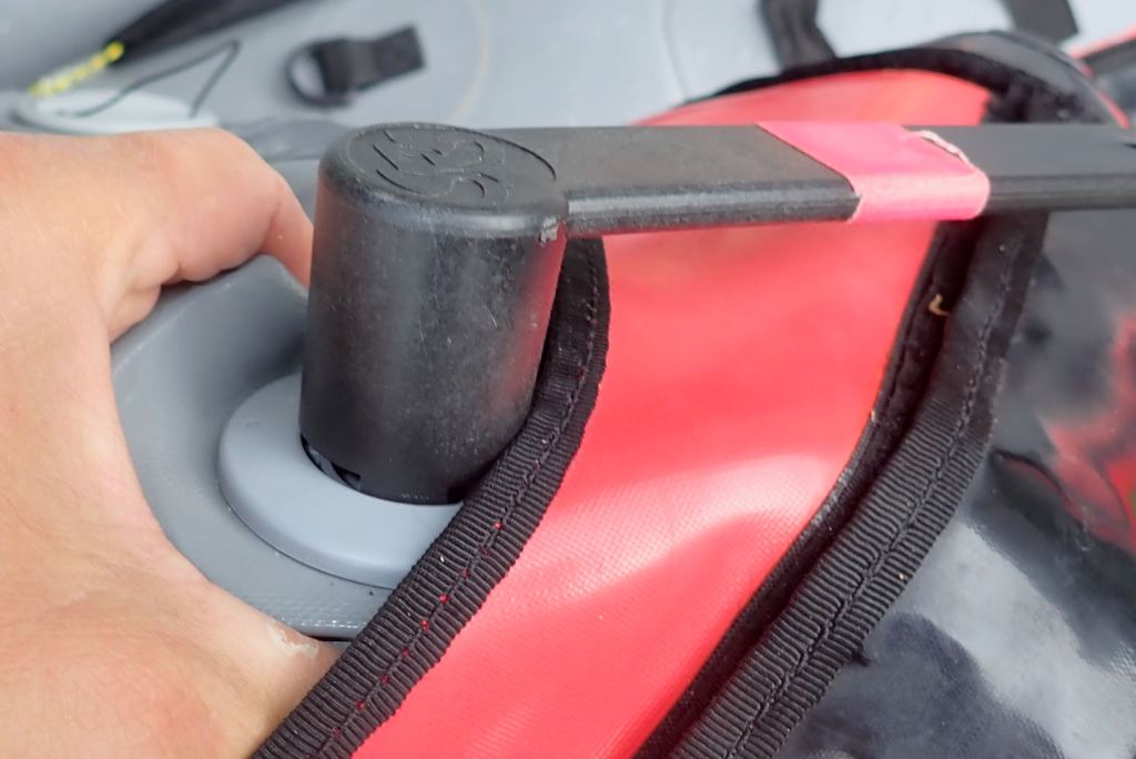
I was taking a gamble trying my untested new rudder set up. Because I expected it to play up, I fitted the stock skeg so I could lift a problematic rudder and carry on as normal without coming shore. To be without a rudder or skeg with a backwind at sea would not be ideal. Being the ever recirculating goldfish, I forgot to try out my sail stick mount idea.
Rye hasn’t been on the coast since 1287 or so when, along with gradual land reclamation, the biggest of a series of 13th-century storms filled the adjacent marshy inlet with silt and shingle which finished off semi-abandoned Old Winchelsea and radically redrew the low-lying coastline where the Kent and Sussex borders meet. It was the same in Pevensey to the west. The gif on the left from this interesting regional website shows how the coastline of southeast England was transformed in the late medieval era. Where the Rother river once flowed directly east to enter the sea at New Romney, the filled-in bay saw it diverted south below the old hill town of Rye, now stranded two miles from the sea. The then important port of Winchelsea was rebuilt on its present site in 1288, but eventual silting saw both it and Rye’s maritime importance decline. What this area may lack in epic spaces common to the north and west of Britain, it gains in fascinating history. 1066 and all that.
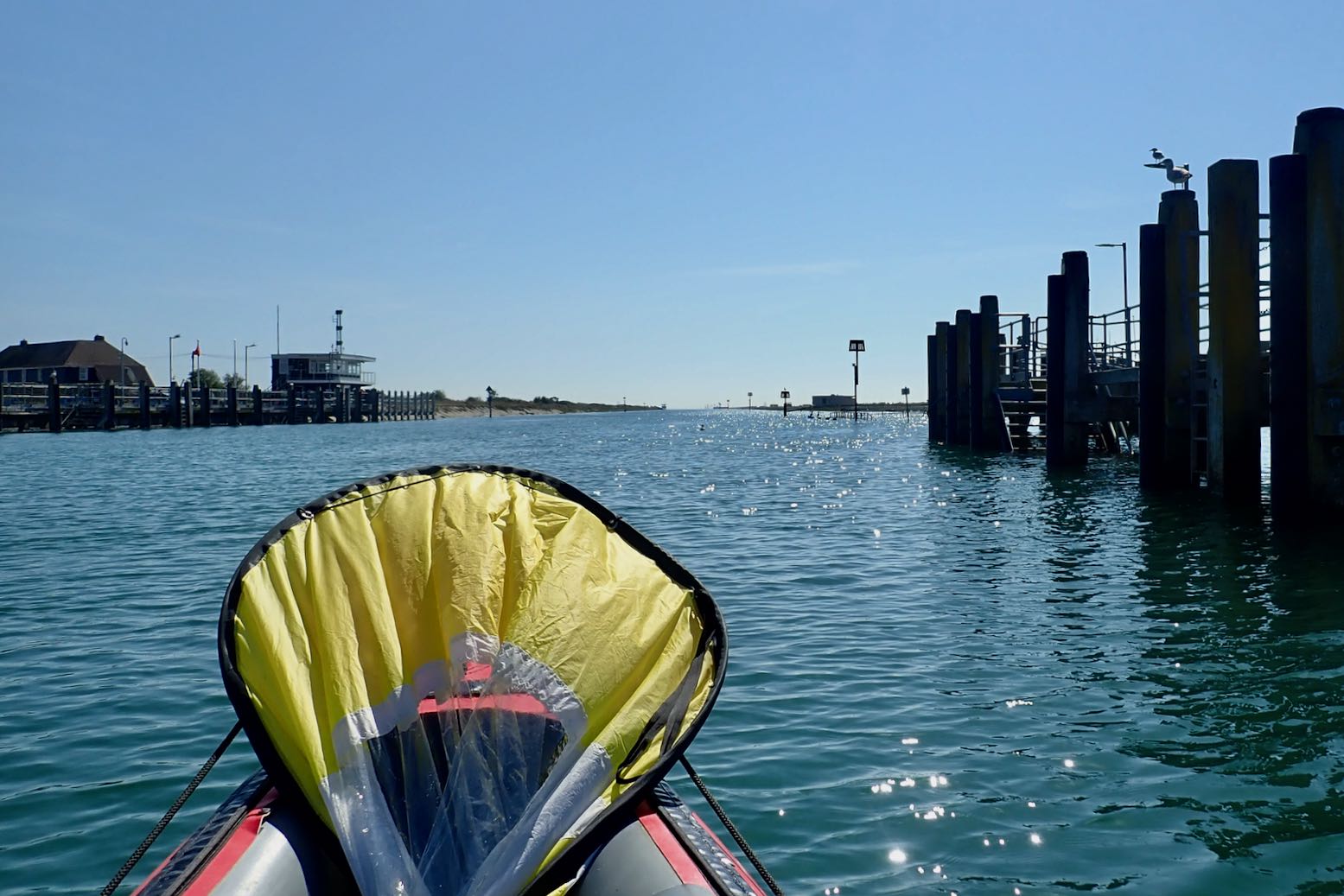
I set off along the River Brede which wraps around Rye’s south side like a moat, and soon joins the Rother. It’s about 5km to the open sea.
I’m into the wind but the grass banks are under water and the wind turbines are spinning merrily; all good signs.
Rye Harbour. The tide is high and I’m moving on.
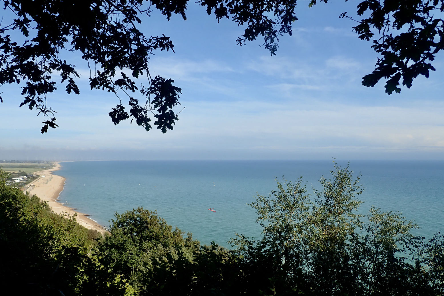
In 45 minutes I reach the old breakwater opposite Camber Sands where I recall bucket & spading as a child. The sea looks depressingly flat.
Seals at the river mouth (a few days later).
It’s nearly 10km to the distant cliffs, a two-hour haul. And with the breeze from behind, I’m soon streaming with sweat. I’m not sure my water will last.
Going with the Flow A few years ago while planning Newhaven to Brighton, I learned an odd thing about Sussex and Kent tides. For the last two hours of the incoming (eastbound) flood, the tide keeps rising but reverses westbound along the English coast as it backs up at the Straight of Dover and spills back down the sides. That makes HW is around the same time in Folkestone, and 140 miles to the west, past the Isle of Wight, but HW at all the places in between lags behind. Tidal steams are not that strong here – wind will have much more of a bearing on paddling – but this means you get only four hours eastboundflow with the flood tide and prevailing southwest winds. But if you time your run with a warm easterly off the continent and go westbound– as I did on this occasion – you get a much longer run with the tidal current; eight hours or more; maybe 45km all the way to Eastbourne. The question is: can you paddle that long.
A breeze picks up so I flick up the sail. I check my GPS and am doing 3-4kph, while I can paddle at around 5-6kph. Then the breeze drops away. I wasn’t really planning to paddle the full 30+ clicks to Cooden station, but I can always get off at Hastings, a few stops before.
At least the rudder seems to working as it should, though any quick response is dulled a little by the skeg. A rudder’s not really needed in these conditions, though it compensates for me being blown gradually onshore. I’m trying a rudder lift-line only, not a rudder lowering line as well. But once in the boat I find I can’t turn enough to even see the lifted rudder to flick it down with the paddle, so I’ll probably fit a drop-line later.
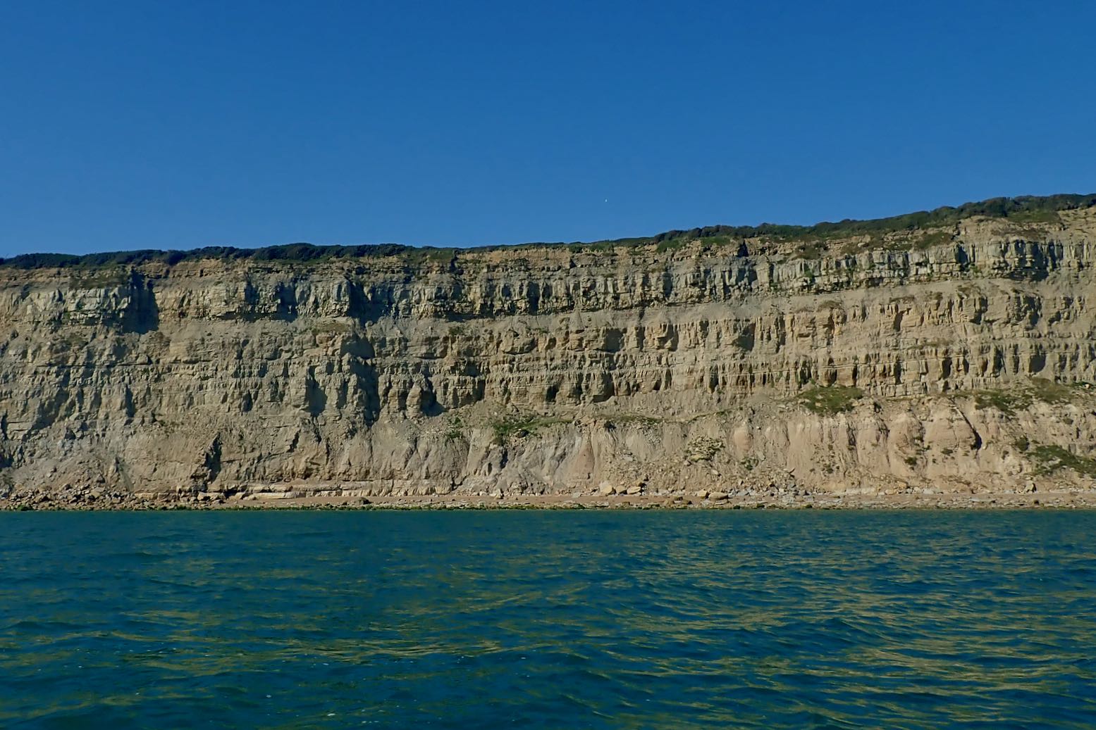
I creep along the expanse of Winchelsea Beach. It’s hot work in a backwind. Eventually I reach the start of the cliffs where the coast turns more east-west, putting the wind directly behind me. But paddling at effectively wind speed, there is no cooling effect. More familiar with paddling at the other end of Britain, I’m not used to 27°C.
Then, as predicted, around 3pm the breeze picks up and I can get the sail up.
Paddling half a mile from the shore, initially it was hard to know if I’m moving and at what speed. So waking up the GPS screen was a handy way of telling if the sailing speed was worthwhile. With the odd gust I reach nearly 7kph, but average less than 5kph, a bit slower than paddling, but I’m not dripping like a leaky tap or needing to drink. In fact I could nearly doze off.
Niblick (5b), Harrisons Rocks
The cliffs inch by. This is the sea end of the Wealden sandstone formation, less high and steep than the better known chalky Seven Sisters to the west, or Dover’s white cliffs to the northeast. Both chalk cliffs are part of the same formation or bed, but when the land was squeezed and uplifted to the dome or hump was eroded away to expose the older sandstone below. This is what they call the Weald, and near Tunbridge Wells, East Grinstead and Frant, the weathered sandstone ridge produces small outcrops where I started rock climbing as a teenager (right).
There’s barely a sensation of movement; it’s not as bracing as I was hoping
I pass the Stade, the east end of Hastings where the cliffs drop back down. A few souls are enjoying the last day of summer on the shingle beach.
I keep going to the pier and decide to have a leisurely take out there. It’s gone 4pm so another 10km to get the train 6.15 from Cooden would be a rush.
Landfall by Hastings pier. Compared to the fabulous Summer Isles, for me these southeast coast paddles lack drama and interest, but are easy to reach if tomorrow’s weather looks good. We walked Hastings to Rye again a day or two later; it took about the same time and was more enjoyable (though it was cooler). The rudder foot pivot worked fine, though needed a bit of re-tensioning at the pier. Next time I can confidently leave the skeg off, though I can see a rudder would only be needed when sailing or paddling in windier conditions. That is all I have to say for now.
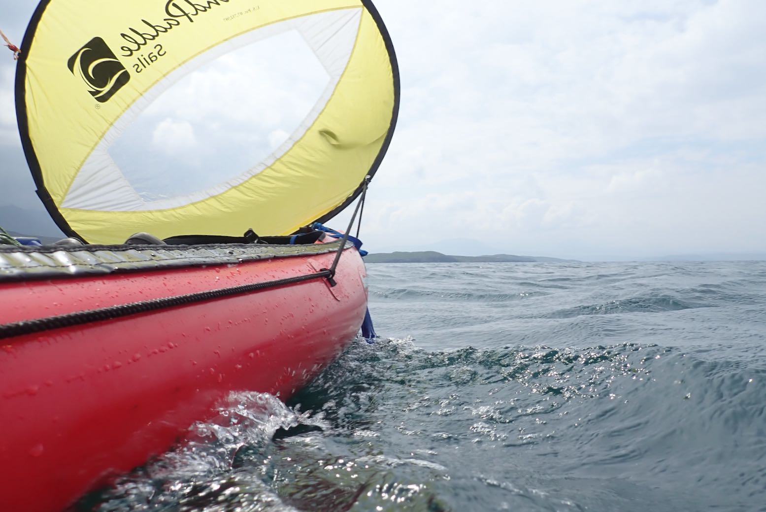
One problem I’ve had sailing my Seawave is the sail tends to sway ever more violently from side to side when the wind gets too strong. This is not just a problem with the WP disc sail I now use (left); it was the same with the Pacific Action V-Sail I used on my Incept K40 in northwest Australia a few years ago. Unable to transfer the wind energy into forward motion, it instead spills over the sides in a flapping frenzy.
It’s well know these downwind sails (especially smaller ones) have a limit of about 15-20 mph beyond which they flip out. But lazily hooking up the WP to my Seawave’s decklines introduces a lot of slack (left) which may exacerbated the swaying. It was only when trying the similar AirSail and later my WP on my packraft in Scotland (at one point with gusts as strong as Australia) that I realised lashing the sail mounts close to the hull eliminated the swaying. At least on a broader bowed packraft.
Out sailing the Seawave the other day, I belatedly succeeded in tensioning the decklines on the water with some ever versatile SoftTies (right). As you can see left, that worked OK but annoyingly it wasn’t as windy as I’d hoped, and not enough to get the WP in a flap.
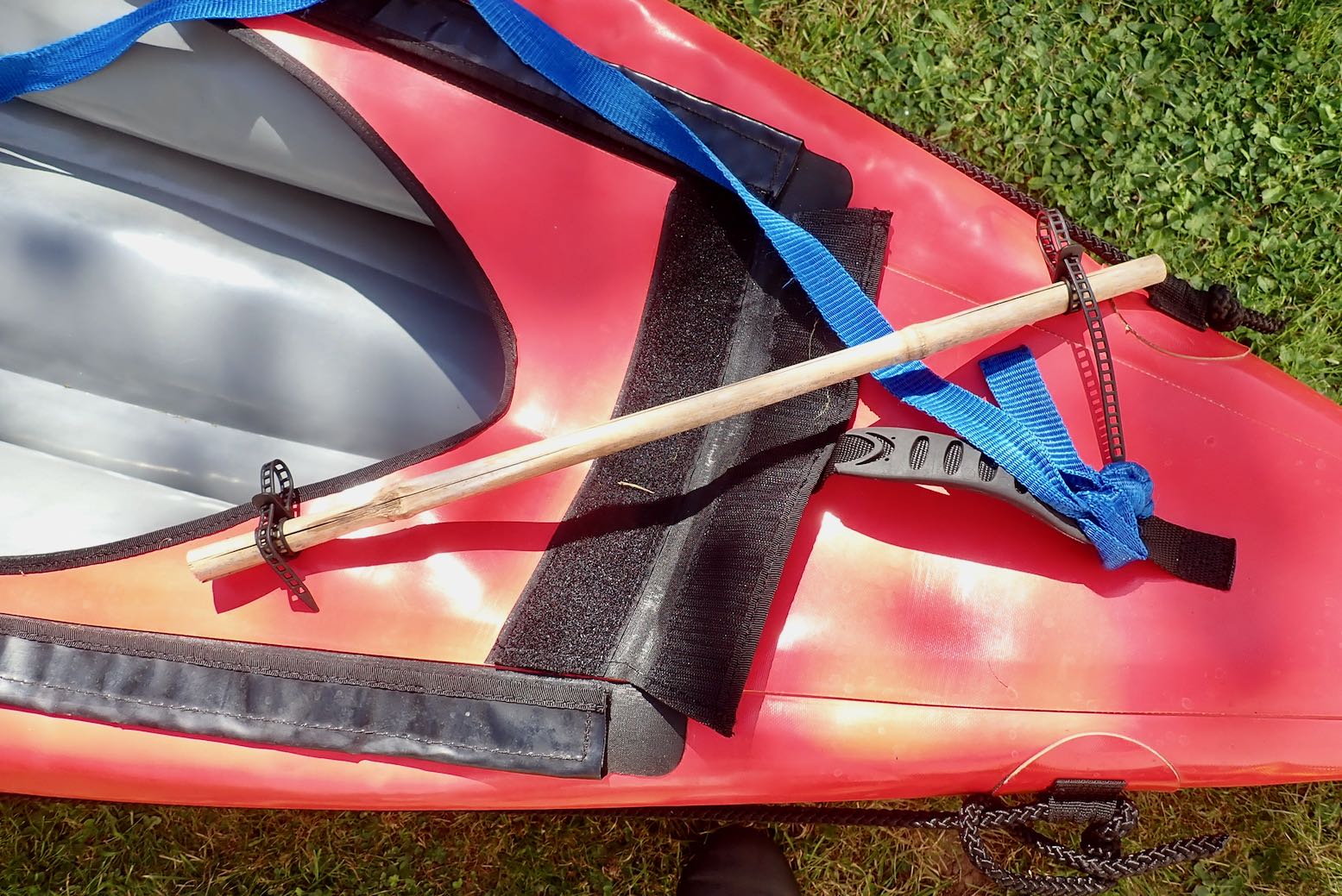
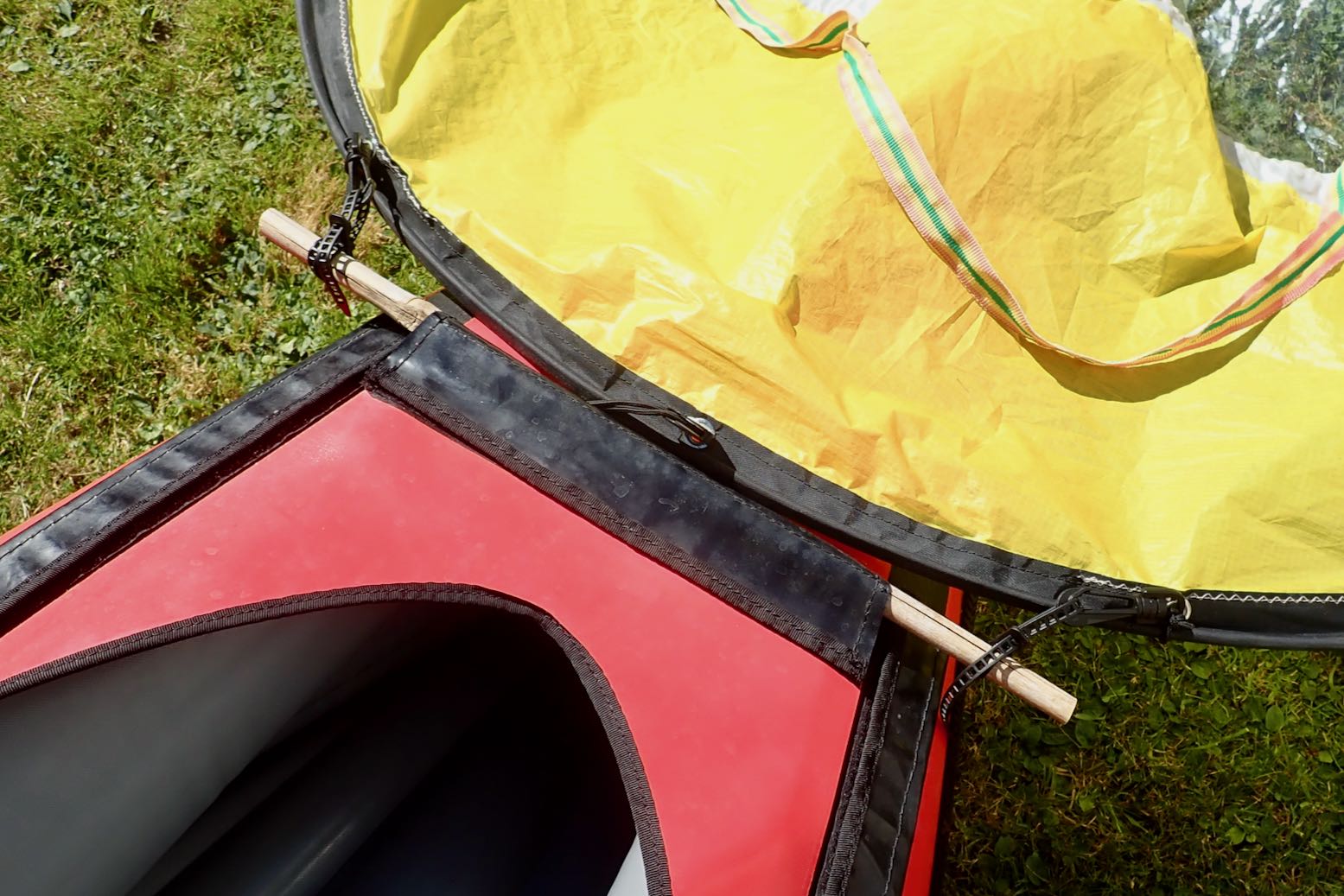
I’d forgotten to try my stick idea. Whether you use the deck cover on not, you can fix a transverse stick securely under the Seawave bow’s velcro flap and, with another couple of those nifty SoftTies, closely fix the WP to the stick. (I’ll be keeping an eye out for a nice bit of ally tube to replace the weathered old bamboo). Required work and added weight: negligible and it may work on other IKs, too. Something to try for next time.
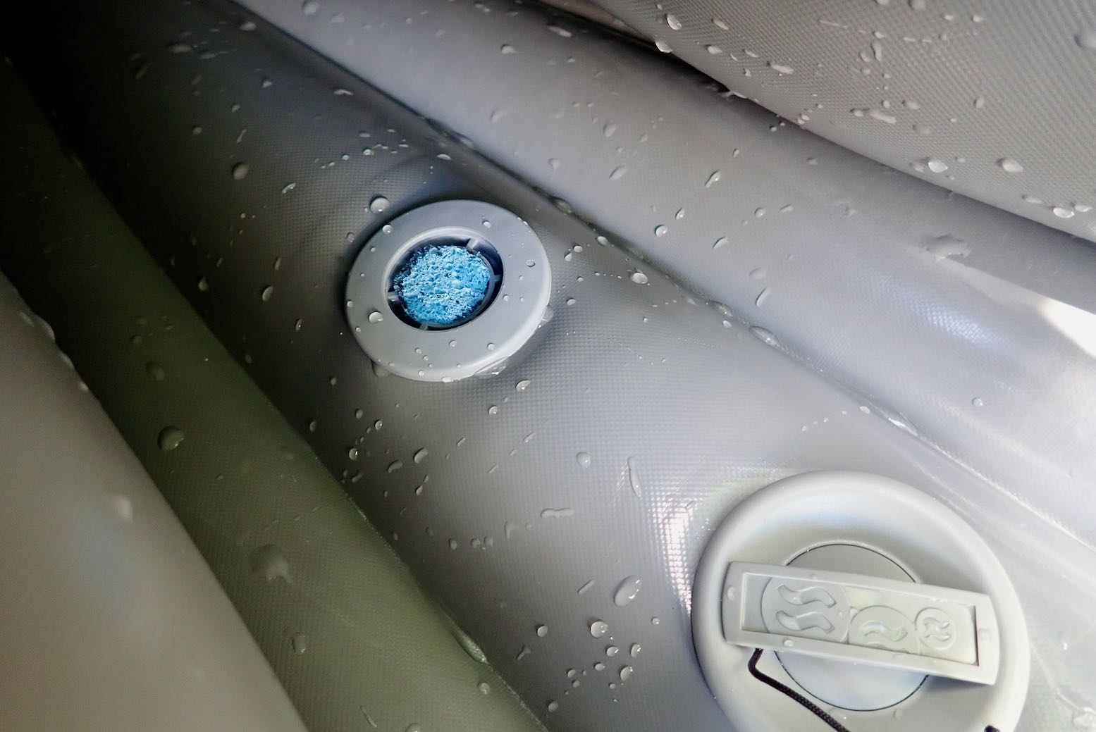
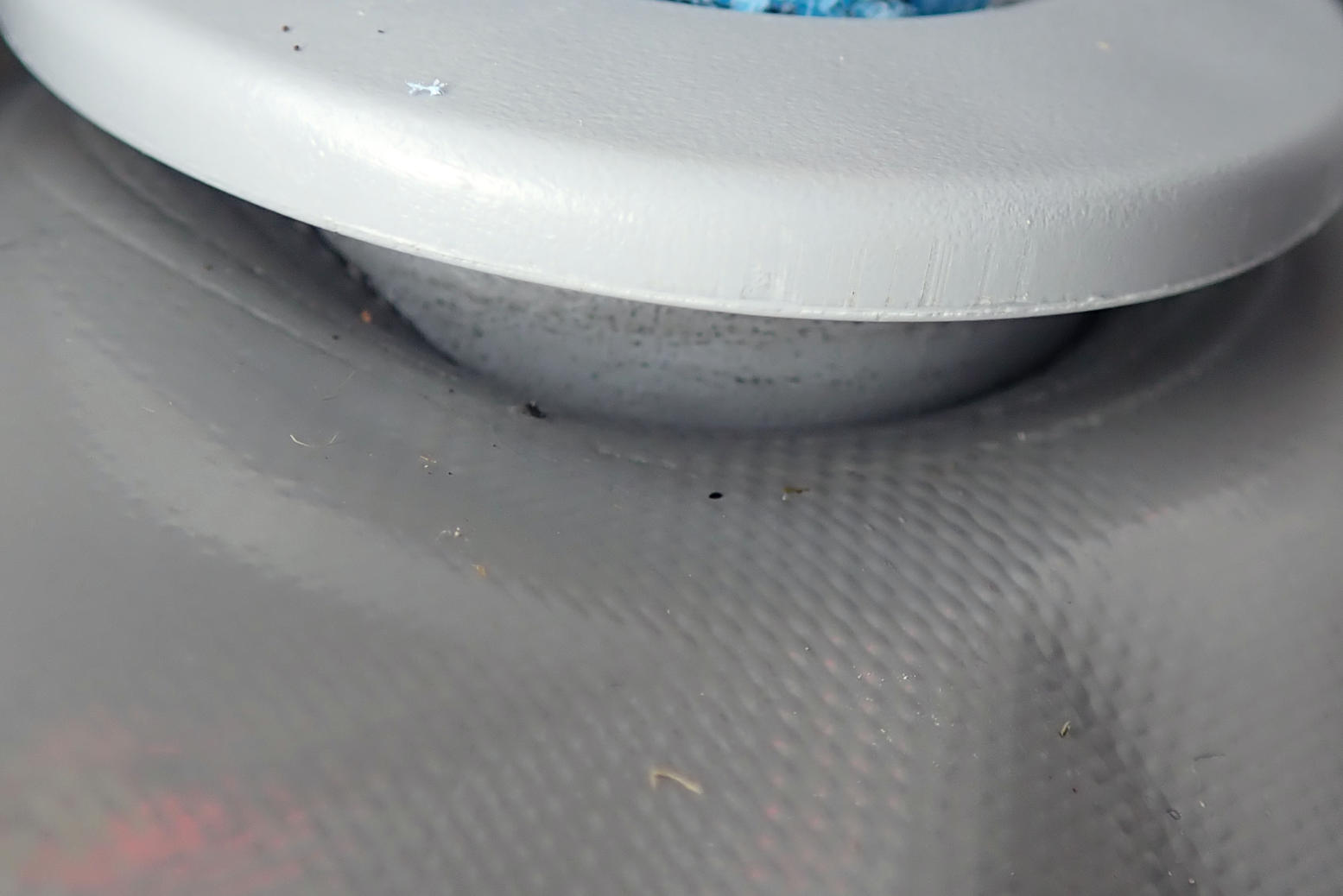
The other day we paddled the Seawave off Durness beach where the surf was bigger than I’m used to. Hitting a breaking wave as we paddled out didn’t help; the swamped boat needed tipping out at the next beach. It was a bit too offshore windy to roam, but it was still a thrill to be paddling on the very top of Britain, just 2175 miles from the North Pole (about the same distance south to the Canaries). After the paddle I took care to dry, wipe down and roll the boat up on a sand-free rock bench, but lacking a hose back at the house, I had to rinse one bucket at time – not ideal. When I pumped up, the floor soon went flat: sand was in the seal of the floor’s PRV (what’s a PRV). It’s a thing that happens but in nearly 20 years of Gumotexing it’s never happened to me. Today was my day.
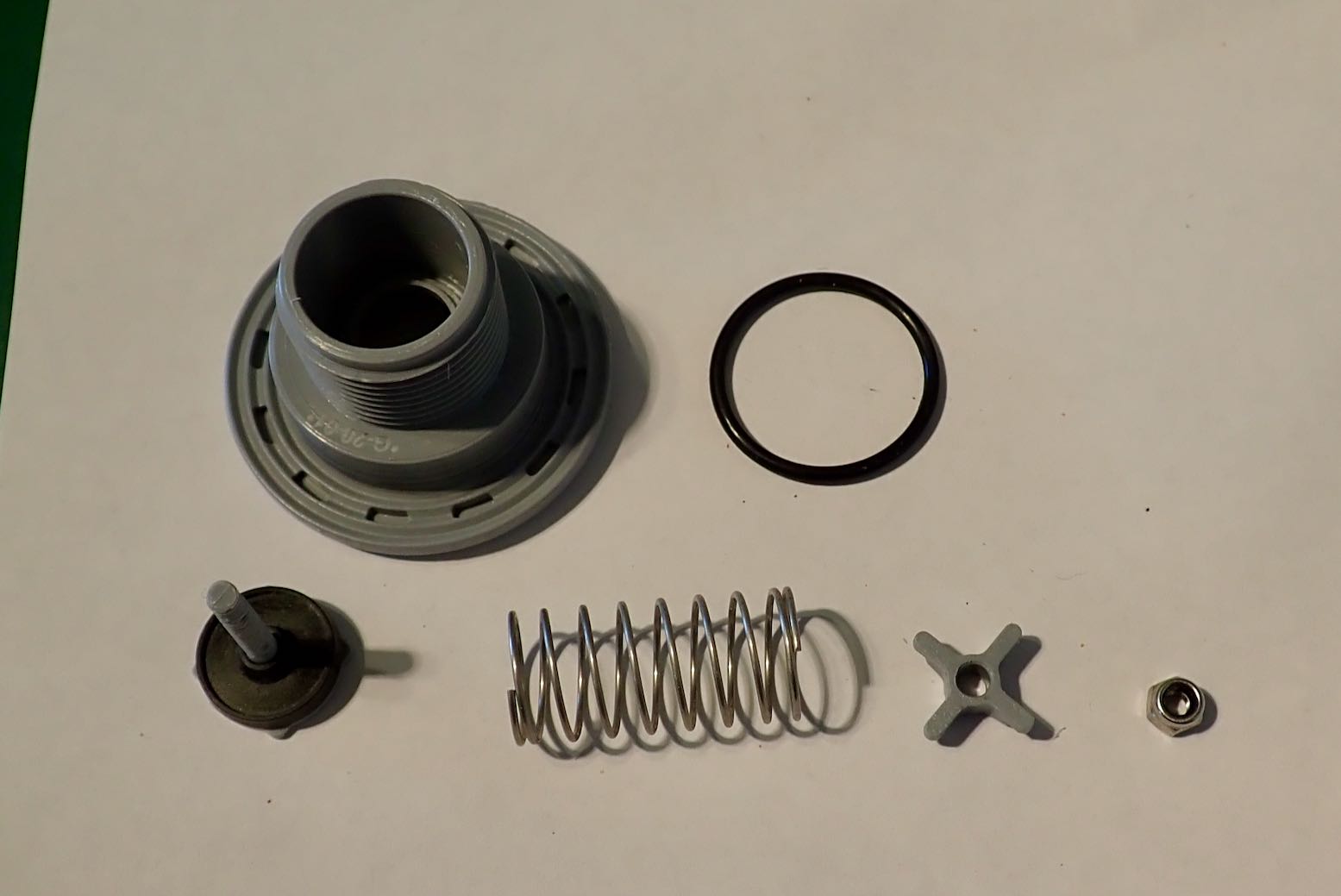
Seawave PRV
The design of the valve means that if the boat swamps in the surf, water laden with grit can enter via the six vents and pool in the valve body right above the seal. The next time it purges, sand grains can slip down onto the soft rubber seal surface and stay there, letting air leak out. Because the chances of this are high, with a leaking floor PRVs are the usual culprit, not the nearby inflation valve with its sealed valve cap, or less still, a puncture. But don’t rule either out (the cleaning procedure for an inflation valve will be the same).
Fixing a PRV Much of what follows is my take on Polishman Marcin S’s translated post linked above. It’s not how I actually did it, it’s how I would do it next time after quite a lot of trial, error and better ideas or procedures though up along the way.
Before disassembly, first try giving the PRV a darn good blow-through by pumping like billy-o and letting it purge. It will help to prise off the vent cap with a small flat screwdriver so grains blow away, not bounce back in. Pump up and see what happens. Chances are it won’t work.
Next I suggest putting the boat on a slope (to save water and weight) and flood the stern to establish the pace of the leak from the PRV. You will do it again at the end to see if there is any change. By dragging the boat around 180°, you can let the water slosh down to the bow while you remove the PRV at the stern at the high end.
Don’t try this; manometer leaking
Small bubbles rising from the PRV
Don’t plug in a manometer to try monitor the leak over a period of time; it cost me a few hours and a disassembly or two before the flooding idea proved my manometer was leaking from the base faster than the PRV. As we know, pressure gauges are plugged in briefly to get a reading, then as quickly removed. To test for a leak, water is best.
Six splines below the vent cap
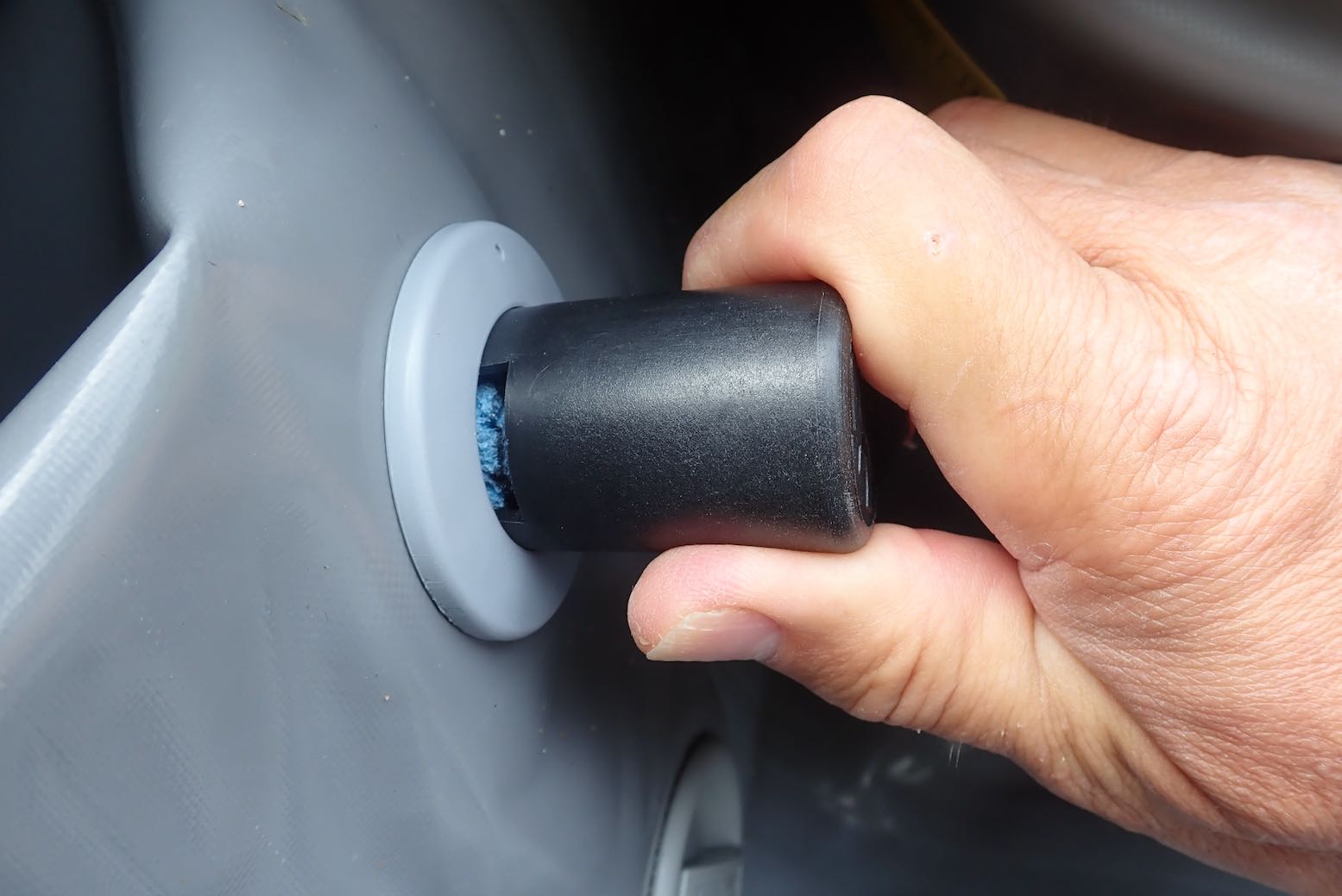
Buy one now
You now know for sure the PRV is leaking so will have to remove and clean it. Flicking off the vent cap exposes the valve body’s six splines. Fit your Gumotex valve tool(or eBay clones from £6) and unscrew the PRV. As Marcin says: the plastic one will do; you don’t need the expensive metal one Gumotex also sell. Expect the PRV to be very tight. Marcin pre-lubed his, I didn’t but it undid easily enough. My boat is less than a year old.
What a tool
Don’t let the backing nut fall away (or the o-ring)
It’s easier to start unscrewing the PRV with the boat fully inflated, but separate the two parts of the valve only once fully deflated so there’s less chance of the backing nut inside the hull rolling away out of reach. Same with the loose o-ring on the valve body base; don’t let it drop into the abyss.
PRV with black o-ring
Rinsing; worth a shot
With the PRV in hand, you can see how it works: a spring-loaded valve opens upward when pressure from within reaches a pre-set level – on a Seawave supposedly 0.25 bar or 3.5 psi (but it might close as low as 0.20). As pressure drops it seals shut. At this point you might try rinsing under a tap while pushing the valve open, but you’re going to have to disassemble it anyway to check the state of the seal.
Set the o-ring aside and unscrew the 6mm locknut on the valve stem. Press on the sprung valve from the other side to stop it spinning as you unscrew the nut. But before you do this, count the number of threads or take a photo (above), as the position of the nut regulates the purge pressure; the more you screw down the nut the higher the purge pressure. I notice Marcin’s nut on his Solar was much less screwed in than mine (lower purge pressure). (At one point I tried screwing in my nut an extra turn to improve sealing, but it didn’t seem to make much difference; still closing around 0.2. Maybe a few more turns are needed, but of course you don’t want to go too far and compromise the floor.
Left: pliers to undo the nut; magnifying glass and torch to closely inspect the rubber seal. Right: the disassembled PRV. From top left: valve body, o-ring, valve stem with rubber seal, spring, spring cross-washer, 6mm lock nut.
Ooo-er, quite a lot of fine Durness beach on there.
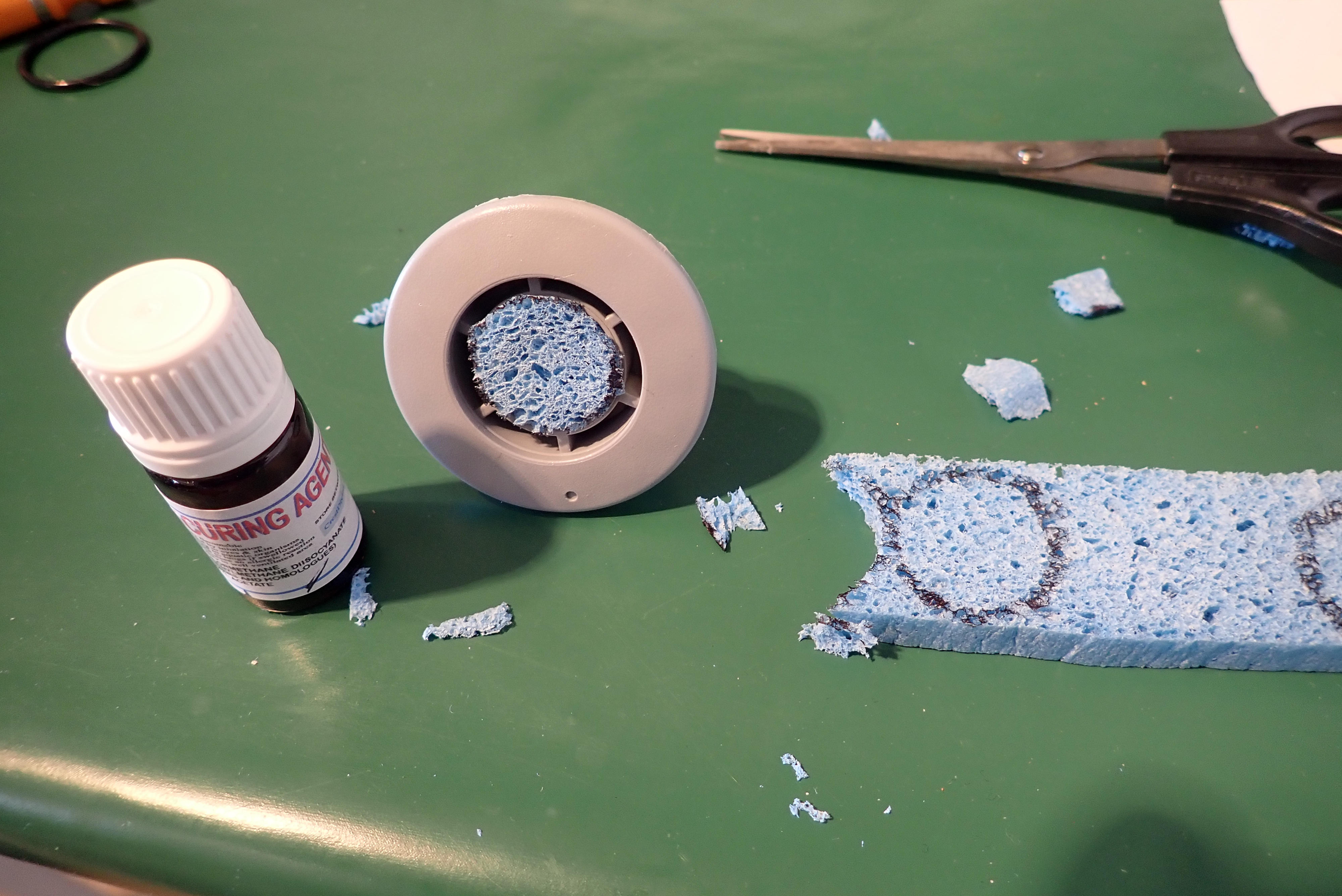
I chose to clean the rubber seal with an ear stick and toluene solvent. (I tried, but decided not to remove the rubber seal from the stem). After carefully wiping off the grains on, around and under the seal, I dipped the whole thing in the toluene bottle cap (not too long as toluene is strong stuff on plastic; it dissolved the orange marker dot). Don’t forget to inspect and wipe the inside of the plastic valve body too.
A lovely, clean PRV seal. Reassemble and carefully screw down the metal nut onto the soft plastic valve stem to where it was – or what you prefer.
Grit-catching foam filter
Marcin suggests sticking some sponge under the vent cap to catch grains in future. Sounds like a good idea. These are easily removed/rinsed/dried or replaced by flipping off the vent cap.
Edge caught in thread
Tooling on
Clip on the cap
A quick Hail Mary to Saint Columba and you’re now ready to refit the valve. You shouldn’t need any lube other than a bit of water for things to reassemble smoothly, though I decided to lube the o-ring with some TiZip silicon grease. I found as you start screwing in by hand it feels like it’s cross threading. It isn’t: the edge of the fabric is getting caught in the thread. Back up and jiggle the valve body and loose fabric around to make sure the body has slotted and centred its flange into the fabric hole. Pump back up, tighten the PRV down some more, but probably don’t clip on the vent cap just yet as you may be going back to square one, as I did (partly because the fitted manometer was leading me astray).
Now flip the stern back downhill and let the water slosh back over the Seawave’s valves. I found the PRV purged for about a minute, then abruptly stopped with an odd underwater squawk … but carried on leaking slowly. Another removal and check and refit and there’s still a very slow leak – a 2mm bubble every 2-3 seconds, but with the floor now lying in the warm afternoon sunshine, that may be normal purging. I decide it’s as fixed as it can be. A few hours later, all was normal again and we are all much the wiser.
Moral of the story: if you think sand-laden seawater may have pooled in your PRV (most likely from crashing beach surf, not normal, deep-water paddle-splash), back on shore flip the vent cap off and rinse the PRV cavity with fresh water, ideally flipping the boat upside down, so any grains flush out.