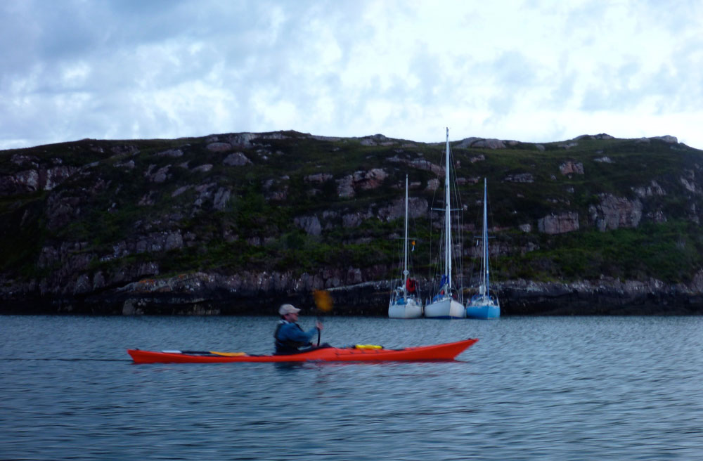
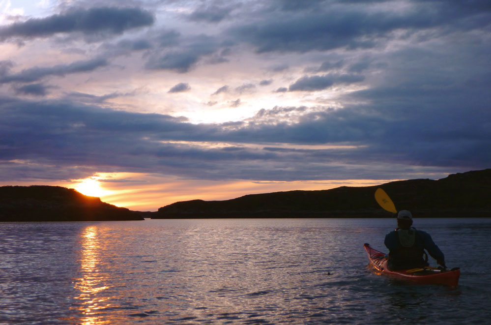
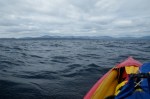
Friday night Jon and I paddled over to the Summer Isles on an exceedingly calm evening. After a bit of dithering looking for a place to camp, we hacked through the seaweed to get onto Tanera Beag about 11pm where we set up for the night. As predicted, it got windy and flapping tents meant we didn’t get much sleep, although at one point a sudden lull at 3.30am did wake me up with a start. Out over Polbain the red sky was already presaging the dawn, just 80 degrees east from where the sun had set 5 hours earlier. Heading back later that morning into an F4, it was nice when that part was nearly over. Near the each I hooked around the and tried a bit of disc sailing – it works but I definitely need a bigger sail. A few days late but I got my midsummer’s mini adventure after all.
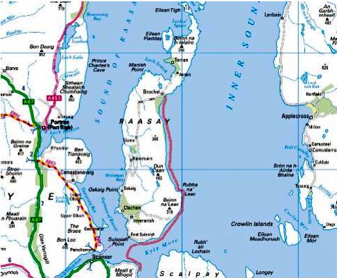
On Saturday May 14, I left Paris very early and drove to Scotland. I arrived in Kyleakin on Skye very late the same day. The last leg between Fort William and Kyle of Lochalsh had been tricky because some large animals were standing in the dark by the roadside. I pitched my tent in the grassy backyard of the Backpackers hostel and eventually enjoyed some well-deserved rest. Morning after, I checked the weather forecast to find out that it was expected to be rough during the next 36 hours, before improving on Monday afternoon. My plan was to complete in about 10 days the last section of the SSKT, the Northland section, from Kyle to Ullapool. Last summer I had paddled North up to Applecross, visiting the Crowlin Islands en route, as well as Loch Carron up to Plockton and the Black Islands. Instead of following the same route, I intended to visit Raasay and Rona before crossing the Inner Sound to Loch Torridon. This detour would also keep me sheltered from the Westerly winds in the lee of Skye.
Before putting off, I went to the police station in Kyle of Lochalsh to inform them about my intended trip. The officer in charge was very helpful and helped me to turn a « going to the hills » form into a float plan. He took note of my leaving my car at Kyleakin: I did not want to be reported missing in case somebody would draw wrong conclusions after noticing a foreign car left unattended for several days.
I launched in Otter Pond after lunch and started paddling westward, hugging the shore which offered some shelter from the SW breeze. I thought I could reach the SE corner of Scalpay by the end of the afternoon and set camp there, but the wind decided otherwise and grew stronger as I was passing Palbay on my starboard beam. Rounding the low features of Rubha Ardnish I felt the full force of the SW gusts freewheeling across Broadford bay. It would take way too much energy to reach the other side, so I decided it was wiser to call it a day and returned to the lee of Rubha Ardnish.
It was high water time. The sea had just risen up its highest, flooding large expanses of grass and patches of sea pinks (armeria maritima). I landed on a bed of flowers and installed my camp at the foot of a rocky bluff offering a natural protection against the wind. Soon the rain forced me to hide in my tent. Cooking outside was impossible so I carefully light my tiny can stove inside and prepared some hot soup.
I took to sea at high tide the following day. Very early then. I had to because the shoals around Rubha Ardnish dry out not long after high water, meaning a long and tedious portage should I miss the time. Crossing Broadford bay against the still fresh SW breeze proved to be a effective warming up exercise. I stopped on the gravel beach in the small drying harbour, protected by an old and crumbling stone pier where some fishing boats were moored. Through the windows of the hotel nearby, I was watched by guests having breakfast in shorts and t-shirt.
Surprisingly as I left Broadford behind me the wind eased off and I paddled through Caolas Scalpay on mirror like flat water. This bliss did not last and I crossed the mouth of Loch Ainort buffeted by the usual SW gusts. I probed into Caol Mor to assess the conditions for this 2 km passage. I found it challenging enough to make my arms feel weak. I postponed the crossing to later in the afternoon, let the wind blow me back around and retraced my last paddle strokes until I could land on a seaweed choked boulder beach for an early luncheon. One hour later the receding tide had left my boat high and dry but I could easily drag it back to water on the thick and slippery layer of kelp covering the boulders. The 2 km crossing to Raasay went fairly well. To my great satisfaction I was whisked by the wind around Eyre Point then to Rubha Na’ Leac. I landed in the small bay behind this headland, hoping to find a camping spot. There was none so I had to paddle on along steep hillsides and stately cliffs all the way to Brochel.
I landed on a pebble beach below the conspicuous ruins of Brochel Castle. Above the beach was a grassy ledge where I pitched my tent. The evening was calm and dry, so I could enjoy my dinner in the open, watching the Applecross hills across the Inner Sound. I paid a visit to the Castle (which is unfortunately falling apart), but it was too late to have a walk to Ardnish along the famous Calum’s Road.
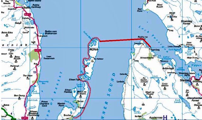
Forecast for the next day, provided to me by Chris, was light breeze no rain until 7 pm. There were even patches of blue in the overcast sky. I paddled to the north tip of Raasay, entered Caol Rona and turned into the narrow passage between Raasay and Eilan Tigh. A SW light breeze pushed me across Caol Rona and later helped me against the current ebbing out of Acairseid Mhor between Rona and Eilean Gharb. Acairseid Mhor is a natural harbour, and a former smugglers haunt.
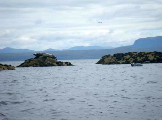
Rounding the North tip of Rona amongst a maze of skerries, I involuntarily scared a score of seals which scrambled into the water from the rocks where they were sprawled. The visibility was good and I could see Rubha na Fearna 9 km away to the East. I looked up to the lighthouse and noticed the flag flying in the wind next to it. The flag was showing that the wind had backed South. That was bad news: I would have to paddle for about two hours in side wind pushing me towards open sea. But the wind was not expected to pick up before the end of the afternoon and I should be safe in Loch Torridon by then. So much for the easy downwind crossing I had hoped for. Two hours later I rounded Rubha na Fearna with a heavy sigh of relief. The wind had alarmingly picked up while I was still in the middle of Inner Sound. The current was running against the wind, inducing some uncomfortable yet manageable chop. I stopped on the sand of a tiny inlet and had lunch.
When I set off again, the wind had backed to the SE. While probably still blowing from South outside, it was funneled along the direction of Loch Torridon. So I trudged along the shore, feeling the wind blowing stronger as time passed, and reached Aird, a headland separating Loch Torridon from Loch Shieldaig. I rounded the north tip of this headland then set a course to Shieldaig island some 4 km away. The wind suddenly accelerated and stopped me in the passage. The water around me became white. I tried hard to move forward, to no avail. I gave up and let the wind push me back out of Loch Shieldaig into Loch Torridon.
Hugging the shore of Aird I paddled into Loch Beag under the pouring rain. I landed on a narrow slipway at the very head of the inlet, next to heaps of creels. Exhausted, cold and miserable I staggered up to a shed were some people were sorting shellfish. The building had an upstairs platform above the working floor accommodating an office, a cloakroom, a kitchen and a bathroom. I was granted permission by the foreman to spend night in the kitchen. This room was also a closet cluttered with various things. The cloakroom stank because of the fishermen oilskins and wellies hanging there, but it was heated and I put my stuff there to dry.
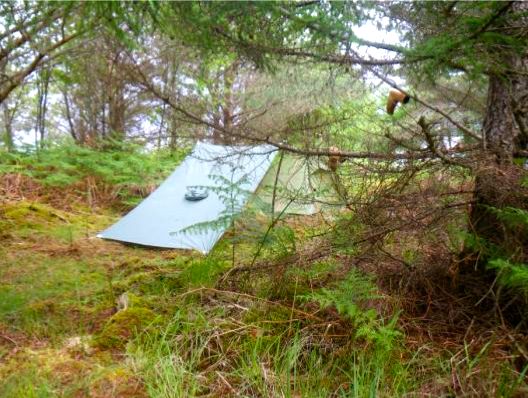
The foreman came back at 7 next morning. I was ready to go and had washed the floor before leaving. Through his binoculars I could see the white crests of rough water outside. However as the wind had veered to SW, it should not prevent me to enter Loch Shieldaig this time. Again I rounded Aird. As expected, I was sheltered from the SW wind. Nevertheless I kept hugging the shore to avoid any risk of being pushed away. I landed on a tiny pebble beach near a shabby cabin. I walked up a soaking wet footpath to explore the woods. There I found an ideal campsite, flat, dry and sheltered by the trees.
I was short of drinkable fresh water. There was plenty of water dripping all over the place but I was not in the mood for going through the process of purifying it, not for setting up a rig to collect rain water, even though I had nothing else to do actually. Instead I decided to paddle another 2 km to Shieldaig, get some water there and return to my secret campsite. I was halfway across to Shieldaig Island when a powerful SW gust hit and I had to paddle like mad to keep on my course to Shieldaig jetties. I filled my 10 litre waterbag and bottles at the tap conveniently located on the creel-choked platform, after a local confirmed it dispensed drinkable water. I paddled the shortest distance to the sheltered opposite shore and returned to campsite.
The forecast that Chris texted me for the following days was still depressing. There was too much distance of west facing exposed coast on my way up north that I could handle in high winds. So I decided to leave the SSKT here, and accepted Chris proposal to pick me up in Shieldaig the next day. I hoped the weather would improve after the week-end and allow us to explore the Summer Isles. It did not happen.
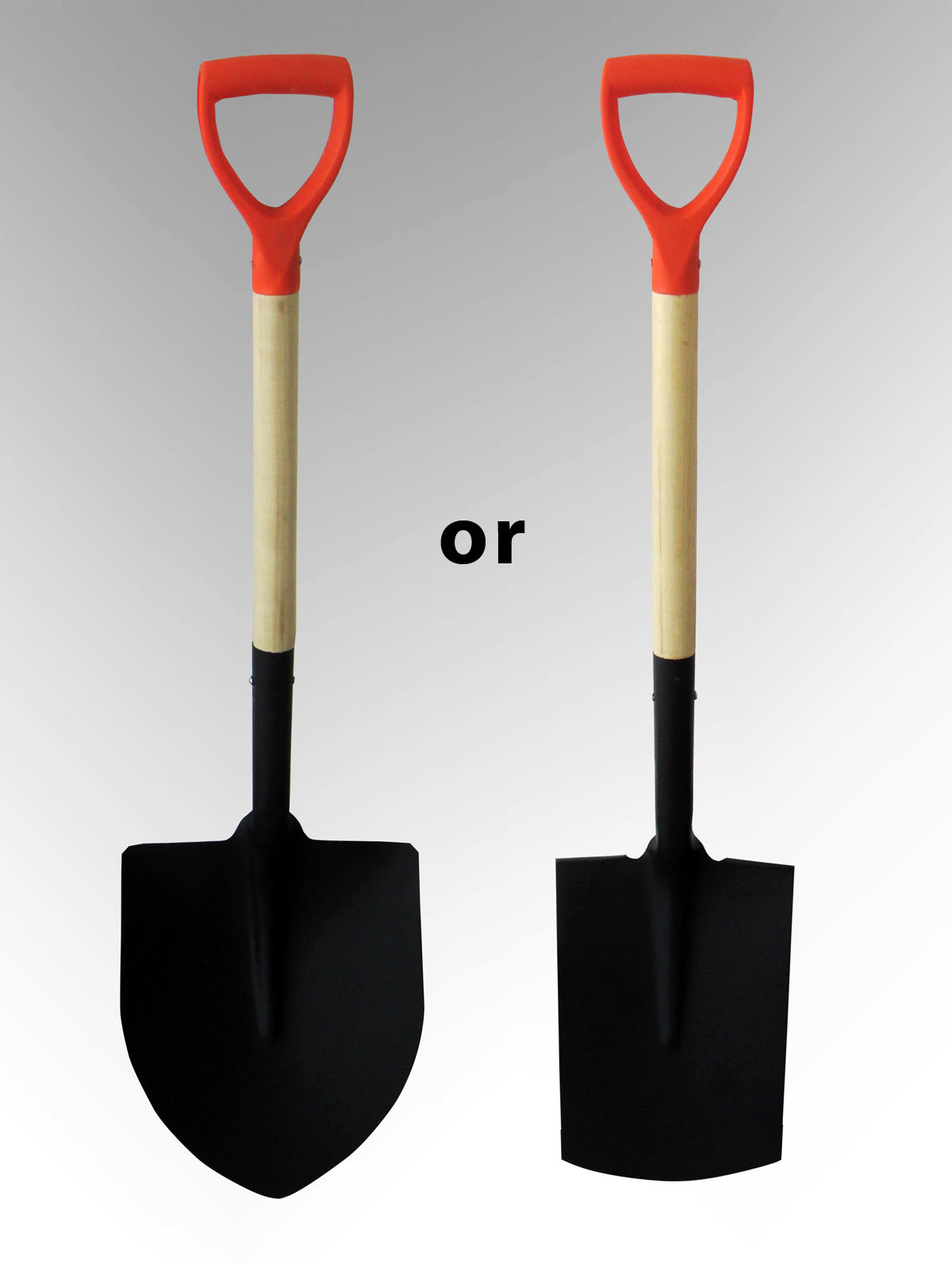
Like most beginners I started my IK-ing with a super cheap 3-piece TNP shovel. Then, after picking up a much better used 2-piece fibreglass Lendal Archipelago which soon seized up, for Shark Bay in 2006 I splashed out on a decent light, rigid, bent-shaft, adjustable offset, low angle 2-piece, 230cm Werner Camano. At £230, it cost more than my first two boats but in all those [17] years I have no regrets. The Camano just works.
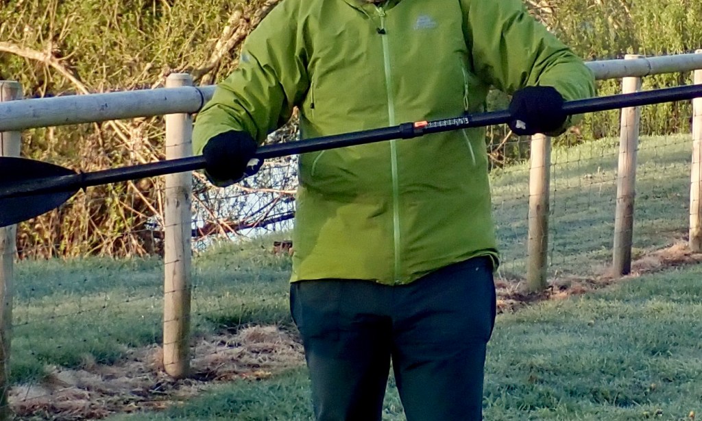
High angling with a low-angle paddle.? All the gear with no idea
To me bent shafts and an indexed, ovalised grip make ergonomic sense for steady, all-day paddles rather than pulling fast moves in rapids. It’s just more compatible with the non-rectilinear human form. I did notice that when I swapped back to theslightly heavier straight Lendal (before it seized) there was noticeably less flex, but over a decade and a half later, the Camano is in great shape and is still my favourite for anything where a compact four-piece is not needed.
The Camano is a low-angle paddle, but I think my style, if you can call it that, is high angle, and in fact I read that high angle is the right way to do it. I find that wide, high-sided and relatively unresponsive IKs and packrafts encourage or require an energetic ‘digging’ style compared to a smooth gliding hardshell.
A paddle for packrafting The way I see it, even more so than most IKs, a packraft has high and fat sides and you sit low inside. So that ought to mean a long paddle to get over all that plastic and into the water. Paddling with the 220cm, big-faced Aquabound paddle, I didn’t really notice any issues other than some squeaking as I rub the sides occasionally. Longer would not have made much difference.
Manta over the Corry; not much in it
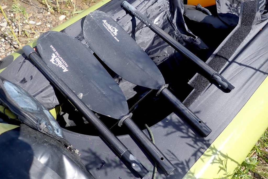
At around 3kg a packraft is extremely light but it’s not an efficient shape for gliding through water like a swan. However, once on the water with a paddler in it, the total weight is nearly the same as a more glidey IK, so it boils down to the need to propel the hull using a paddle with a large surface area. Some might say a bigger blade will mean more yawing, but I figure you just dig less hard and anyway, with practice, yawing is easily controlled once moving. Providing you have the strength, a bigger face ought to give the speed which packrafts and IKs lack. There are times (mostly at sea or on white water) when speed and power can mean safety. In the US I got myself an Aqua Bound Manta Ray 4-piece high-angle in carbon (above right, 220cm). Weighing under 900g this one feels more flexy than the Camano, but fits right in the bag and so makes a great packrafting or back-up paddle – apaddleinyourpack, so to speak. Mine has the two-position snap button offset which I run at 45°. You can now get an infinite-position Posi-Lok version. The compact and light Manta Ray (70cm longest section) is ideal on short day trips with public transport and with no load to haul on the water. It was fine for a decade of UK packrafting and makes a great packstaff, too, but it didn’t always come apart easily like the Werners. Dry or wet, don’t leave it assembled for days or weeks, especially after sea use (that probably goes for all multi-piece paddles).
I used my Manta sea kayaking in Australia as well as packrafting – it was fine for both. For the price this is a great paddle – so good I sold it to my Ozzie mate and bought another right away. I’ve never seen a 4-part Manta for sale in the UK, but in Germany the Anfibio Packrafting Store sells TLC Mantas as well as their own Anfibio Vertex 4P (left).
Err, how does this work then?Anfibio WaveAll adjustable
Or they used to. Now they sell their range of own-brand sticks. I recently padded with a chap with their four-part Wave which weighs 991g and comes with infinite angle and 10cm of length adjustment (210-220cm). I would guess the blade is <650cm2. The longest section is 64cm and all that for €125 is very reasonable.
Corry 721cm2 • Camano 650cm2 • Manta Ray 677cm2
I also have a straight, fibreglass-blade Werner Corryvrecken (£200 years ago). It’s the biggest paddle Werner do in 210cm+ 2-piece touring paddles: 721cm2 blade area compared to the Camaro’s middle of the road 650cm2. and 677cm2 for the Manta Ray.
At 220cm (same as the Manta Ray) I’ve also gone as short as I dare to get over the fat sides of a packraft. There’s no indexing on the straight, carbon shaft, just a little ovalisation as on the Aqua Bound. The Corry’s face is a tad bigger than the Manta Ray (left and above) but the whole stick feels much more rigid (it’s 2-piece). It’s 7% lighter than the Manta Ray and 17% lighter than the stiffer Camano – initially you notice this. I compare my Corry and Camano in my Incept sea kayak here.
More weights & measures According to the kitchen scales the weights of these paddles are:
Werner Camano 230, 2-piece – 988g – stiffest
Werner Corryvrecken 220, 2-piece – 816g – lightest
Aqua Bound Manta Ray 220, 4-piece – 880g – least stiff but cheaper
Anfibio Vertex Multi Tour 210-25, 4-piece – 890g – cheapest; multi-use
So now I have a long, comfy low-angle Camano for long, loaded IK or packraft sea trips; a straight, I sold the rigid, light, shorter big-faced Corry, and the Mrs likes the thin-shafted Anfibio Vertex Multi Tour 4-piece.
No doubt about it, the K40 is fast enough for an IK. Last night was a calm but chilly evening, not very inviting so I settled on some effort and endurance rather than relaxed fun, nosing along the coast. Alone and without my usual dry suit, the initial agoraphobia certainly helped with the digging. But for goodness sake, the sea was barely stirring apart from an eerie swell, so I dared myself a dash over to Tanera Mor (left). It’s only a 25-minute crossing.
The day before a kayaker fell in heading in the other direction back to Old Dornie and ended up being rescued by the coast guard (one press version here with a few small errors). I was told only one of the two kayakers actually fell in and although experienced, couldn’t roll or exit instantly, possibly as a result of cold shock? I presume it was that effort along with, like me, not being ‘dressed for the swim’, that brought on the reported hypothermia and associated helplessness. There were several other kayak rescues reported around Britain last weekend. Certainly up here it was the first sunny and calm couple of days in ages which must have brought paddlers out, even if sea temps haven’t caught up and may never do so.
I kept upright and sustained a sweat-inducing 4mph plus for half an hour, peaking with the aid of some unnoticed surge at just over 5mph (8.5kph or 4.6 knots). I suspect that in similar conditions, a slick fiberglass sea kayak that’s six inches narrower and six inches less high can cruise at around 4–4.5mph all day, and I’m also told that at sea you should bank on an average of 3 knots (3.5mph, 5.5kph) when estimating distances. On the last leg, going east against the ebb and a light breeze didn’t make much difference to my speed. Until I was spent, that is. In the absence of sunny vistas and a warm breeze to linger over, it was a good work out. See also a similar test with my Grabner. This was my first proper outing with the thigh straps. It wasn’t rough enough to test them, but I’m sure they enabled me to keep the speed up. This is partly due to the fact that, like so many IK seats, the Incept backrest collapses as you lean on it as it’s far from rigid, no matter how much you inflate it. It’s why I got an Aire Cheetah seat for my Sunny years ago, and why, along with its mushy footrest, the g-friend can’t get the most out of her Solar (top left; I fixed it later). When you lean back on an inflatable seat – even attached to the hull tops (the highest point) – it still just folds down from the arch of the lower back. This leaning from the middle-lower back rather than pushing from the lower back/hips is partly to do with a lack of solid footrests in the Incept and Solar (before mods). All this squishy inflation certainly creates comfort but is also the biggest performance drawback compared to hardshells – even if you do read of SinK Sit in Kayak hardshellers complaining of numb limbs until they find their ideal boat/set up. One reason a sea kayak can manage to be just 22 inches wide is that you can jam yourself into it – hip, thighs/knees and feet – so it fits and responds on the move like a running shoe, not a woolly slipper – a nifty analogy for SinKs vs IKs. Without a solid seat or footrests, the thigh straps on the Incept do their best to replicate a hardshell’s underdeck thigh pads, enabling me to sit upright because the backrest as it is can’t provide that support. If that means more strain on my abdominal muscles, bring it on! As I mention elsewhere, with the deck zipped up there’s normal back support off the coaming that’s still mushy enough not to make you sore as it would do on a SinK. Open deck, one solution would be to incorporate some rigid sticks or a board into the backrest to stop it scrunching down – like a Cheetah in fact. At one point on the Sunny, before I got the Aire seat I had a board jammed in behind me to help push off the box I used as a footrest. And so I conclude: seatback with the top down, not so good no matter how you adjust it; thigh straps good any day of the week.
One thing you lack in open deck mode on a K40 or any open IK is flat space for any sort of secure storage or fitting points. It’s the same story on a packraft. Trying to emulate a professional, I went out with my new large SealLine ziplock map case which lay at my feet. Gael turned me on to these. Unlike some walking map cases that I’ve seen over the years, it’s clear on both sides and best of all is big enough to give you a whole day of map on view if you fold the map right, so avoiding unnecessary fiddly openings on the water or in the rain. Online walkers’ reviews seemed to rate the Ortlieb roll-top equivalent, and claimed the Seal Line will split at the ziplock, but even if it’s simpler, I can’t see roll-top anything being as bomb-proof on the water as a ziplock, and Gael’s had his still-unyellowed SealLine for years before it developed a tiny hole on his last trip.
Back to stashing; of course you can attach everything to some point on the boat, Gael managed fine in his H2, but bits of string around your legs doesn’t seem such a good idea unless you’re really organised. I tried paddling with my Peli 1400 box (left, with a lid-net I plan to fix on – bought here) under my knees the other day, but handy though it was, that wasn’t going to work. It would be better fixed behind me. A Peli is easier to open and close quickly and reliably than my yellow Watershed bag (also ziplock closure), but I think it’s shape will make it a much better ‘day hatch’ bag on an open IK and a packraft, even if closing it securely as a hazard looms may take some luck. Of course in zippy deck mode you have quite a lot of flat space, even if the Incept’s deck stretchies are almost over my feet (the thin shock cord is indeed too flimsy as Gael mentions). But top on there’s enough flat deck space by the hatch at 10- and 2 o’clock to stick a D-ring or velcro. One way I’ve got round this so far is packing it all on the pfd. Certain things belong there sure, but you can end up feeling like some special forces dude, waiting the the signal.
You can attach things to your thigh tops which are within reach and sight. The SealLine map case will clip around a thigh. I’ve tried doing the same with an Aquapac GPS case strapped round the leg; it’s OK and can hook to my drysuit’s relief zip tab to stop it slipping down when walking, but it’s all more junk hanging off you. Compass excepted, a GPS isn’t really a vital gadget in clear conditions. On the sea a legible and accessible map is handier. Still here? Then there’s a good page of improvised deck tech on ukrivers – but of course it’s all oriented towards hardshell SinKs.
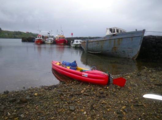
Let’s begin at the end: rolling up the K40. I followed the instructions provided in the leaflet. I removed the footrest airbag and the thigh braces before rolling the boat up and it took one or two attempts before I managed to roll the boat exactly as on the leaflet picture. The resulting bundle (right) was a bit thicker than my Grabner H2, but a bit shorter and I could put it back into the wheel bag provided by Sea Kayak Oban without any trouble.
Back to the beginning. I inflated the Tasman on the grass at my parents’ place in Brittany last Friday afternoon and checked the pressure with the gauge of my Grabner pump. The PRVs started hissing at 0.3 bar (4.5 psi) so the Incept runs the same pressure as the Grabner boats, yet is significantly stiffer than my Hypalon H2 once inflated. The H2 collapses flat when deflated, while the K40 keeps most of his shape, hence the initial difficultly in rolling it up into a compact bundle.
It took me some time to fine-tune the footrest and the rudder controls as I am 6’ 4” (1.93m) tall. I found a much better way to attach the rudder return shock cords to replace the previous messy knots, using a simple taut-line hitch. The lines are too short to make the hitches accessible from the cockpit with the deck on, but I can adjust them in open deck configuration.
Talking of which, the rudder which comes with the Incept (left, below) is a beautiful piece of gear; much more serious that the piece of plywood and hinge which came with my old Grabner (but is still an expensive option).
The deck zip didn’t slide so smoothly but was improved by rubbing a piece of soap along the length of the zip. The spray skirt (right) is a rather ordinary piece of neoprene and nylon with braces. It’s been a fight to fit it around the flexible coaming (despite the rod inside) but it should become easier after some practice. The cord tension of the two crisscross bungee lacings fore and aft of the cockpit can be adjusted by cord locks, but I think the 3mm lines are too thin – 5 mm (5/16″) would work better. I don’t trust such flimsy deck bungees, and any item put down under them should be secured to the boat with some kind of leash. A leash can be attached to the perimeter grab line or to some additional D-rings to be glued to the deck. There are two unused fittings on the outer side of the K40 alongside the cockpit, through which I run bungee straps. Inside the kayak they run through the D-rings where the thigh straps are attached. The holds of the K40 lack any D-rings; there is nothing to attach basic kit (bailer and sponge, painter, water bottle, map case, compass, spare paddle) to the boat. I’ve got to order those NRS patches Chris mentions here.
On the water Early on Sunday morning I loaded my K40 on my car roof and drove to a nearby put-in, Fort Espagnol that juts into the placid waters of the rivière d’Auray. It was sunny when I launched but it soon became overcast. I spent the next five hours on the water, riding the lively currents of the Golfe du Morbihan getting up to 10.1kph (6.3mph). Although those currents were rather mild as it was neap tides, they created enough chop in some places to test the behaviour of the K40 on short bumpy waves.
I made a short visit to the stone circles on Er Lannic (below) and made a stop behind the eddy next to the infamous Grand Mouton beacon. The current is still fast although it’s the end of the ebbing tide. The Incept K40 is definitely faster than my H2. It was difficult to assess my average speed because I was paddling in currents most of the time, however I wouldn’t make headway so easily against the tide with my H2. The thigh straps proved to be very effective in handling the boat in rough water and against the current, enabling the paddler to hold a better paddling position and to cling to the boat.
We parked up at Loch Raa where we’d tried umbrella sailing last year without much success. Initially G said we were nuts to go out in this wind, so we sat in the car and ate our butties like a semi-retired couple in a Peak District car park. But by the time I’d finished working out a way to attach my home-made sail to the Incept’s bow, she was already on the other side of the loch. This was my first time trying out my 0.78m2 sail on a kayak, but I’d recognised the value of sailing in Australia a few years ago with a mate hooked up to a Pacific Action (PA). Here in the UK I get the feeling sails on sea kayaks are seen as even less sportsmanlike than rudders – just not cricket, but an Incept IK is excused from such protocols. Anyway, in terms of efficiency my home-made jobbie wouldn’t be a patch on a proper PA, but I’m not planning on crossing the Indian Ocean just yet. Made from an old tent and with the ability to twist down to half the deployed size, my rag sail was a good way to experiment with the idea and techniques of sailing. If it came to it, I can buy a PA or Bic anytime.
The wind was still batting over Loch Raa (Ardmair recorded a max of 33mph today) so I hacked upwind, flat out at 2-3mph, drifted round and let my rag sail get a fill. Considering the paddling effort it took to get there, I wasn’t exactly ripped out of my seat, but that’s probably a good thing for a first go. I was concerned a side gust might catch me out and pull me over. I took a few downwind runs and found myself cruising at around 3.5mph, topping out at 4.3mph once I neared the downwind shore at the end of the fetch.
At around 4mph it begins to get fun, with the bow carving through the waves. Stability was great, I never felt out of control and would have like to have gone a bit faster. All I had to do was stash the paddle, hold onto the string and foot the rudder. In lulls I needed to support the sail with my paddle (left), but later found if I let it reach forward it stayed up. Set up for a packraft, my control string was a bit too short with the sail six feet ahead of me.
I did try to steer and travel off wind by twisting the sail and ruddering, but not sure I fully got the hang of that. Doing this takes two hands to pull one string back, but if I rigged a rigid handlebar into the string (a bit like a water skier), that might enable one-handed twisting, plus easier holding at other times. Or perhaps a cinchable attachment to the hull is the way to go, leaving yours hands free to who knows, add a little paddle power. Thing is, if I hacked into the wind at 2-3mph I could probably have paddled downwind at 4mph. I may try a proper downwind paddle v sail test next time, but as we all know, what downwind paddling gives you in push, you put in as tracking effort to avoid weathercocking, especially without a rudder.
At the wind speed that day, sailing wasn’t so much about going faster as saving effort. Plus it was more fun than I expected to surf along for free, mainly because it didn’t feel at all risky. But this was on a small loch with waves less than a foot high. Half an hour earlier on the sea the chop was a couple of feet; I imagine that would require more concentration and with less possible speed on the rougher surface.
Sailing downwind you don’t get the sensation of the wind in your hair, but the GPS and the splash off the bow tell the story. On one run we rafted up and the sail still pulled us along at over 3mph which was pretty good for two fat boats. As I approached the shore on my last run I lifted the rudder and straight away the back came round, as it seemed to do when I tried sailing in a pack raft. So it seems a rudder or at least a skeg is the key. To steer accurately with a paddle would be pretty tricky, but I may try that one time. Visibility wasn’t really a problem; to get a closer look just tug it back out of the way.
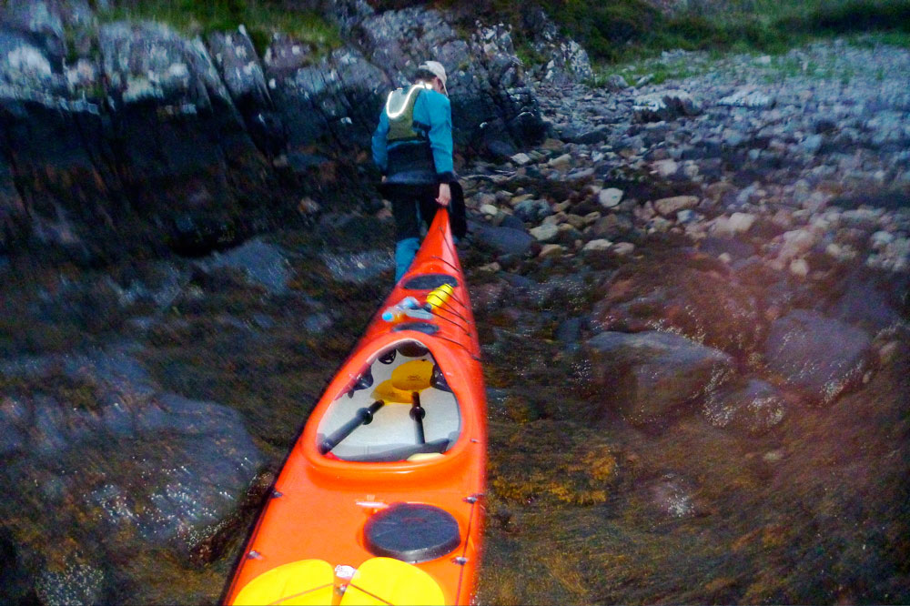
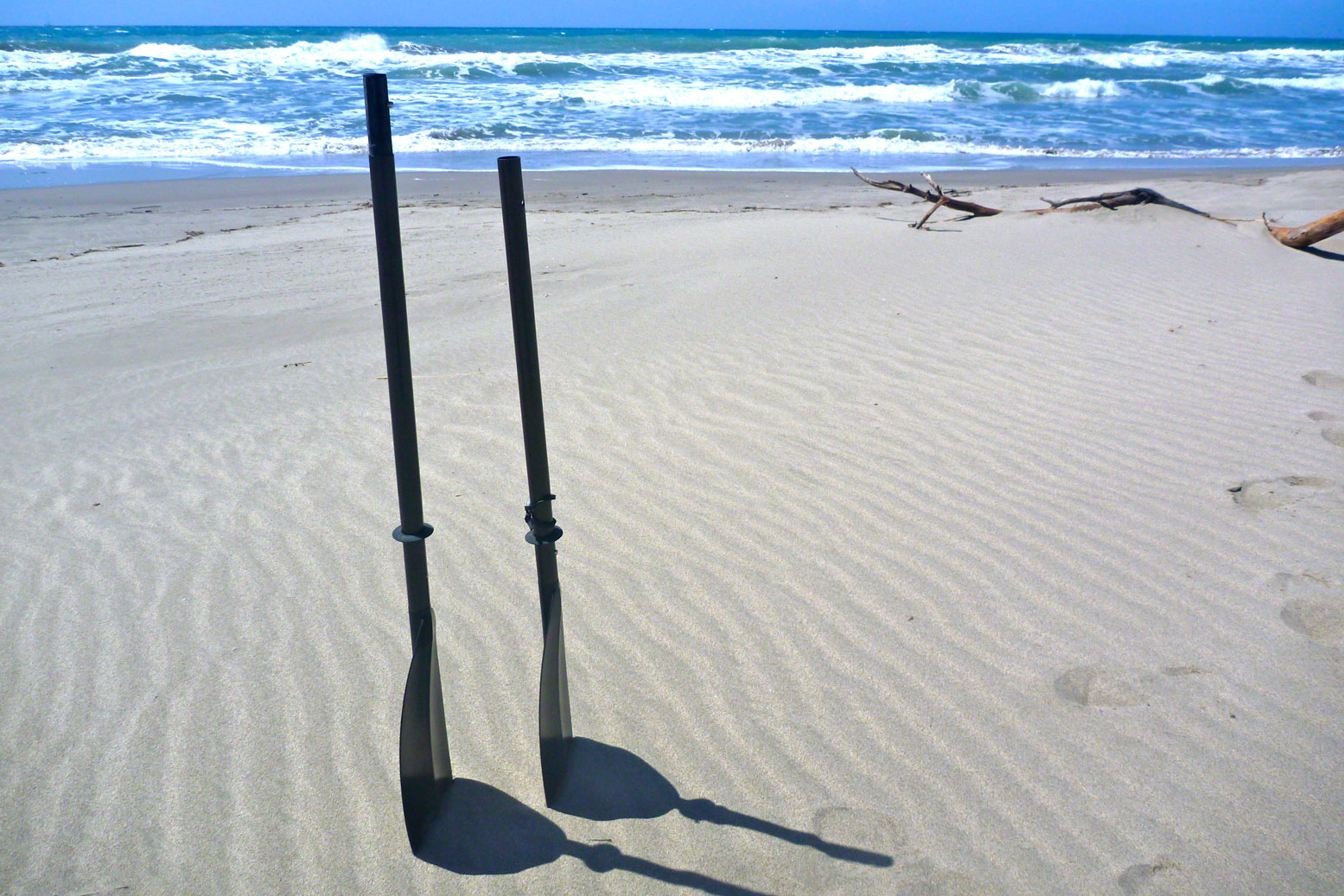
Having thought it all over, I have updated my hypothetical analysis of the £50 Bic Sail (left) on the main packboat sailing page with a couple of pics. For the couple of hours it took me to make my disc sail, I think fifty quid on something that has actually has some kayak-based testing and design put into it is not such bad value. I also tried out my thigh straps. Problem was one of my messy patches had half unglued so I couldn’t put any force on them. But they fit well, are comfy and easy to adjust, don’t feel like they might trap you, and are a definite improvement for either powering on or boat control in choppy water. The positions marked on the Incepts hull felt just right.
Gale warning 23 May 09:53 UTC Violent storm force 11 veering northwesterly imminent, decreasing gale force 8
That storm hit some 200 miles west of here in Rockall, but you get the picture; it’s kite-shredding weather round here right now. Friday afternoon Ardmair near Ullapool recorded nearly 100 kph (62 mph), while we sat at the window and watched the sound run with streaks of foam. The way it’s blowing now I’d not be surprised if it gets over a 100 this week. As it turns out, along with us, the weather station up the loch went down in a 4-hour power cut at the height of the storm, but by then I read it reached 100 mph (160 kph) on the other side of Scotland.
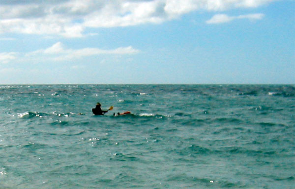
A week ago intrepid French IK sea kayaker Gael A. set off from Skye to complete the Scottish Sea Kayak Trail (SSKT) which he started last August and wrote up for this blog. At that time he managed a fair chunk of the route before the weather turned. This time he was far less lucky; after a record hot April in the UK, May is turning into a bonanza harvest for wind farmers. By last Tuesday Gael had crossed over from Rona island to the mouth of Loch Torridon (above left, midway on the 9km crossing) and got up as far as he could before the fierce wind forced him back to camp.
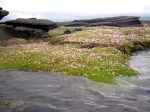
Next day he reached Sheildaig, at one point noting the spring tide flooding a patch of wildflowers. The forecast summaries I was texting him were not promising: days of F5-7 ahead. He was in a fix because from Torridon he had an exposed 45-km section past Gairloch to get around Rubha Reidh headland before turning east towards Loch Ewe, the Summer Isles and Ullapool, the finish line of the SSKT. Providing we could handle the conditions, Jon and I had hoped to meet him ‘after the scary bit’ somewhere around Loch Ewe and paddle for a couple of days together.
Gael is pretty experienced – 40 years sea yaking man and boy – so by Wednesday night he knew the game was up in the time he had left. Next day I drove down to pick him up and take him back to his car on Skye, if for no other reason than it’s a fabulous drive across Wester Ross that I’d not done before. There are scores of dramatic valleys like that up here and Loch Torridon itself is a fabulous spot I’d like to return to with my packboats. The whole of the northwest above Skye really is something else as the many touring bikers and pushbikers were no doubt finding out for themselves. The tiny hamlet of Sheildaig is a time-lost, lobster-pot fantasy tucked up an inlet. It didn’t take long to find Gael so we went over to his camp by the jetty, loaded the car and headed to Skye.
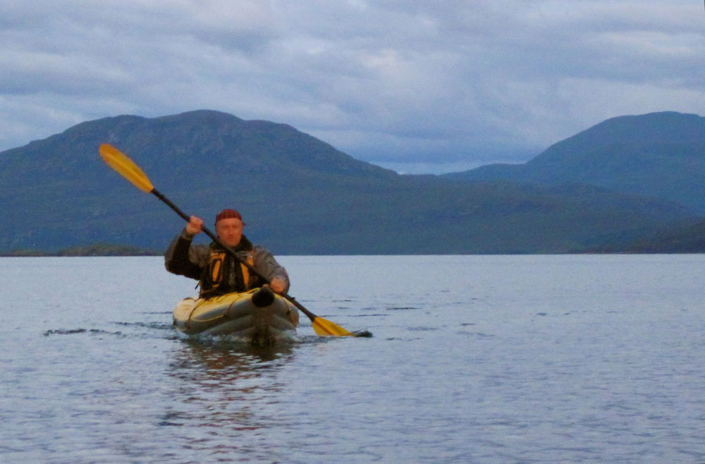
The Sound of Sleat off Kyleakin (left) was calm enough, but out beyond the bridge the sea had a bit of a head on it. We had a 1970s-era lunch, Gael checked out with the police in Lochalsh and decided to hang out up here on the off chance the weather improved and he or we could make a little tour of the Summer Isles. He was also keen to try out my Incept as his Grabner was showing the years. In fact is was he who last year pointed out that Incept K40 had evolved since I last checked it out. For me it was also a good chance to interrogate an experienced sea kayaker about the Ways of the Sea. Among the many skills I feel I lack is the judgement to know when it’s safe to got out and when I ought to turn back: interpreting clouds and wind changes, forecasts and sea states. It’s a lot of stuff to understand so we spent Friday chatting while refreshing various forecast websites: Saturday looked like a bit of a lull so Jon came up to for a paddling threesome.
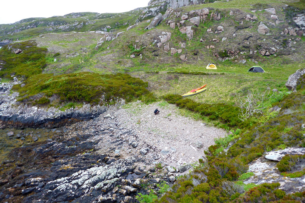
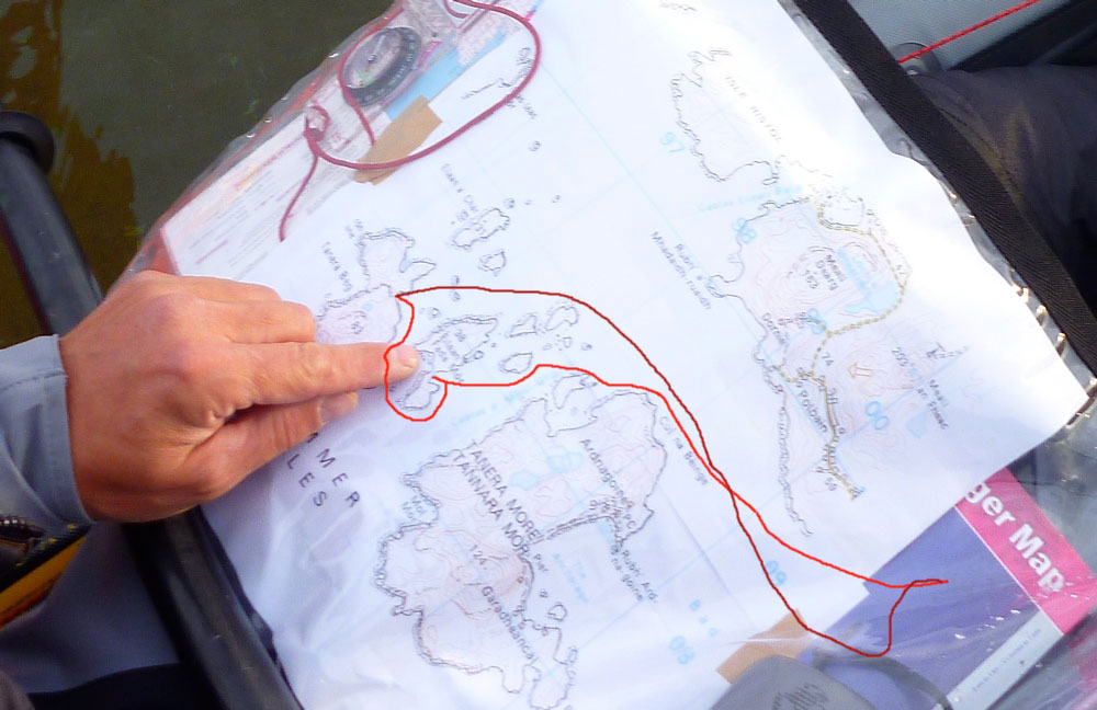
We did the best we could on Saturday and set out from the campsite beach (left) to plant our flags on the calm side of Isle Ristol (which you can walk to at very low tide). Old Dornie was standing room only that day as a local skiff racing regatta was on, postponed from last weekend when Jon and I spent our time daring ourselves to do something and go somewhere.
Sat in the back of his aged H2 Grabner like a canoeist, Gael was far more confident than us – pushing out over some surf raised by a reef while we scurried away, appalled. We beached on Ristol for lunch then turned around into the wind blowing through Old Dornie harbour, dodging the skiffing crews (right) hauling out to a buoy and back to the cheers of the crowds until – to quote Gael – it got at least as ‘lively’ (below) as the previous weekend when we’d taken a while to get the hang of it all. Hauling against the wind the two clicks to the main Summer Isles looked a bit of a reach.
We turned back to the campsite launch as it filled with tooled-up sea kayakers who I fear were not going to have the great weekend’s paddling they’d come for. We headed over to Achnahaird Beach on the north side which ought to be either sheltered or with an offshore wind, depending on how you looked at it. Once in, I pointed to a Point and said let’s go there! but the Wise Old Man of the Sea advised we keep along the leeside cliffs in case the wind picked up as was predicted. The sea was flat enough between gusts but had a big, rolling swell which was an odd sensation I’ve not experienced before. I wasn’t sure if I should be anxious or just enjoy the ride.
Once in a while a series of bigger swells rolled by and churned around the outcrops, or crashed against the red sandstone cliffs, but without any real danger to a boater as there was no surf. We’ve all seen impressive sea kayaking long lens shots like that; relaxed yaker in profile with a backdrop of white-foam carnage. Even under skies which looked like they were about to collapse under their own weight (choose any pic nearby), it was a nice end to the day, running past the moss-clad cliffs and spooky caves from which pealed unrecognisable squawks. A lone seal popped up from a distance to check us out and to the east rose the naked spurs of Suilven, Cul Mor and Stac, carved out of the Assynt’s bedrock during the last Ice Age.
Jon glided along in his LV like he was on rails; you got to hand it to these hardshell SinKs, they may be a pain to carry on the Tube but they sure look good on the water – viewed from the stable-as-a-cow-pat perch of an IK, of course! Heck, it all felt like proper sea kayaking. Further up, around Rubha na Coigach headland I dare say it all gets pretty hairy, but it sure would be nice to cruise further along this coast with the Mrs some warm, calm and sunny evening.
And before the weekend was done, Gael got onto Sea Kayak Oban and bought their K40 test boat which I tried out last March. He got a great deal all things considered; I’d have bought it myself had I not already ordered my yellow boat. So that’s at least two K40s in action on the high seas; mine, his and maybe yours too soon.
I was not actually used to camping in the rain. My personal survival mode turns on with the first rain drops. I started worrying about staying dry when I heard the rain drumming on my tent that first morning in real Scotland. When I had decided to do a paddling trip along the Scottish west coast I knew what to expect. I was prepared and had enough room in my tent to dress and pack critical items such as my sleeping bag in drybags. Removing the inner tent gave me even more space to have a comfortable breakfast. When I broke camp the only wet thing was the tent flysheet. Yet I still wondered how long I could cope with these conditions. I had spent this first rainy night in a campground near Luss, on Loch Lomond west shore. I had arrived there at dusk the day before, after a long drive from Paris. The beauty of the landscape made me forget the weather as I drove along Loch Fyne. Inveraray was packed with tourists despite the showers. The rain didn’t stop until I reached Tayinloan on the west coast of Kintyre. I thought I’d find the Oban tide table in the tiny shop but I was wrong. I had to return to Tarbert where I should have stopped earlier. There I found the Oban tide tables at the tourist office. I bought some midge repellent, bread and peanut butter.
It was still early afternoon and I had enough time to cross to Gigha and set camp at the Ardminish boathouse, but I had to solve the problem of where to leave my car. According to the SSKT guide book I could leave it on the ferry car park but I didn’t want to worry about it during the next 2 or 3 weeks. So I decided to go to the Point Sands campground and get permission to leave my car there. I pitched my tent on the grass just behind the beach and spent the rest of the day preparing next day’s navigation on maps.
First paddle strokes in Scottish waters No rain this Sunday morning. I inflated my Grabner IK (inflatable kayak), sorted out my gear, packed it in the appropriate drybags and carried it all down the beach. It was low tide. The sea was calm but the low and dark clouds looked ominous. I was ready to push off at noon. Soon I was riding the small chop of Gigha sound, and I relished this moment that I had longed for many years. The 5km crossing to Gigha was the first leg of the trip. It was neap tide so the current in the sound was negligible. The paddling conditions were good so I could skip stopping at Ardminish Bay and paddle on towards the northern tip of Gigha. Thanks to the excellent visibility I could see the Gamnha Gigha rocks and light, and identify Rochanan Point in the distance. I took aim and paddled across the sound again and had a first encounter with seals on Gamnha Gigha. They are the same color as the rocks so I noticed them only when they started moving. I landed on Rochanan Point after 4 hours at sea. I was hungry. A NW breeze took up while I was having lunch. The wind and the chop were manageable and I crossed Loch West Tarbert with reasonable effort. I went around Ardpatrick Point then to Rubha Cruitiridh across Loch Stornoway. This bay was a possible landing if the conditions worsened and prevented me getting round Kilberry Head. I stopped on a small beach to relax, have a snack and empty the boat of the water that had splashed in during the crossing. The wind kicked up again around Kilberry Head and the clapotis rocked my boat in all directions. The rodeo-like ride went on until I passed Port Ban. Soon I landed in Miller’s Bay on a postcard-perfect sandy beach. Behind it I found a grassy spot occupied only by two sheep, half a dozen cows and many rabbits. I pitched my tent, gathered wood, cooked some noodles and watched the sunset. My first paddling day in Scotland was almost over. I had paddled 32 km (20 miles), overcome the head wind and ridden the clapotis. I had faced the same conditions many times before, but for some reason I had thought it would be more difficult in Scotland. Of course I was wrong.
Through the Dorus Mor I expected to meet the same conditions along the following sections of the route. But Kilberry Head was the last exposed stretch of coast before a safer area of inshore waters. I was now protected from offshore weather by the high paps of Jura. The conditions that usually make this place tricky are strong currents during spring tides and south-westerly wind. Tides were neap so the current was negligible, and the wind was just a light northerly breeze. Fortunately for me the danger that the SSKT book warns against were non-existent and the crossing to Point Knap was like paddling on a pond.
Rubha na Cille I stopped for a quick lunch near Rubha na Cille and indulged into a short nap before taking to water. The sea was flat now. The breeze died as I was ploughing my way towards Carsaig Bay. Paddling on this mirror-like water would have been boring save for the fantastic landscape I had around me. I had never met such incredible skies, nor such mountains towering above such a glistening sea. I didn’t find a camping spot around Carsaig Bay but had enough time to pass the Dorus Mor with the end of the flow. The, dead calm conditions were ideal for this passage. From Ardnoe I took a course to Garbh Reisa, the island marking the entrance of the Dorus Mor. This passage is a dangerous race in spring tides. The instructions given by the SSKT book were to reach the entrance at slack water and go with a beginning tide. They were valid for spring tides, but it was neaps and my plan was to cross at mid-tide to take advantage of the fastest current and add more distance to today’s mileage. I was late and I started feeling some current only when I reached the north tip of Garbh Reisa. To the west appeared the gap between Jura and Scarba, the infamous Gulf Of Corryvreckan, where a deadly whirlpool forms in spring tides. I gently glided around Craignish Point then turned north, expecting some push from the remainder of the flow. I looked to the shore to assess my speed: I was stuck, even being pulled slightly backwards to Craignish by some invisible eddy. I was not sure of the right move to make, get closer to the shore or away from it and closer to Reisa Mhic Phaidean. I had read that currents might be surprising in this area so I took the first option. I followed the shore until I found a suitable landing and camping spot in Bagh Dail nan Ceann, where I arrived just as I began feeling sore arms. After pitching my tent in the tall grass, I picked some wood for the stove. I found a rather big piece on the pebble beach and used my folding saw and Finnish knife to split it into kindling. I kept my Yak paddling suit on as a camp suit and it worked well, keeping me warm and dry without overheating while paddling or shivering while on the shore.
Inshore waters I woke up to the song of rain and wind. No surprise; the forecast had announced moderate wind save for squalls from the West. I had company under the tent flysheet: slugs and frogs were having a morning meeting on my face. The first effort of the day was to get out of my sleeping bag, the second was to put on my Yak trousers inside the tent. They were cold and clammy and making my feet break through the latex ankle seals was a chore. The rain stopped and as the sky cleared I enjoyed the view on distant islands to the west while sipping some hot coffee. After an easy crossing to Luing via Shuna south tip, I paddled northwards hugging the shore of Luing to dodge the ebbing current in the sound. I stopped in Toberonochy where I could get some water from a gentleman who stopped some masonry work to fill my water bag. I went around Torsa in the company of seals and rode a convenient eddy created by the current ebbing from Cuan sound that brought me to Seil. There I stopped to wait for the flow at the entrance of the sound of Seil. I entered Clachan sound not long after low tide but there was enough water for my kayak to glide over the kelp. Soon I passed under the famous bridge over the Atlantic, then through a narrow and shallow canal, and eventually emerged among some islets just north of Puilladobhrain. There I met a group of kayakers from Oban. Their leader came over to say hello. She even added that my kayak was nice. I was surprised as most hardshell sea kayakers usually find any IK ugly. We parted company and I headed to Kerrera taking a direct course to Rubha Seanach, Kerrera’s southeast tip. It was an open passage, out of the protection of any island. Mull was too far away to offer any significant shelter from the westerly breeze but it was manageable and I liked to feel the moves of the swell again after two days of lake-like conditions. The impressive Gyllen castle came into view and soon I entered Port a’Chaisteil. There a confused clapotis was stirring the water, making shooting pictures difficult. It was no better in Port a’Chroinn, the beach on the southeastside of the Castle. I went out of the bay, turned left around Rubha Seanach and entered the relatively flat waters of Kerrera sound where I paddled downwind up to Little Horse Shoe Bay, looking for a suitable campsite.
Crossings – Kerrera to Kilchoan I was thinking about today’s route while spreading a thick layer of peanut butter on a Breton pancake. I had water for at least another 2 days, food for another 2 weeks. I had OS maps covering the coast up to Lochalsh and the Skye bridge. I needed no additional equipment. In short needed nothing in Oban. So why bother? I decided to go around Kerrera clockwise instead. The west coast of Kerrera was rugged and beautiful. The view over the Firth of Lorn to Mull and the distant Morvern hills was promising. There was no shipping traffic except some fisherman and a barge or two. The ferry traffic was concentrated in Mull sound, going to and from Oban on a route that passes between Lady’s Rock and Lismore. I stopped on a shingle beach in Slatrach bay. This place offered superb camping and I promised myself to return and spend some time here. During spring tides the crossing to Mull has to be accurately timed in order to avoid being dragged in the race that forms between Lady’s Rock and Duart Point. It was still neaps, the tide was ebbing and I would just need to compensate a slight southbound current. I took a course to Grass Point against a moderate headwind. The visibility was excellent until I reached the middle of the 6.5 km (4 mile) passage where I saw thick cloud rolling down the slopes of Mull to the head of the sound, progressively concealing the landscape. I watched Lady’s Rock lighthouse as it started fading in the haze, while Eilan Musdile lighthouse was already invisible. I was now facing the situation I feared so much, being caught far from the shore in the way of large ships with little or no visibility. I knew it was strongly advised to have a VHF radio ready in busy waters, but I didn’t think it could prevent a collision. I ought to be wearing a fluo jacket but I had forgotten it in my car. I had the one solution every sea kayaker has left to escape the danger zone: paddle faster. So I did until I reached some fishnet buoys which were a sure sign that I was out of the shipping lane. I reached Mull and hugged the rocky shore. The wind picked up and showers became stronger and more frequent. I paddled under the conspicuous crenellated tower which ornates Duart Point; a heavy shower prevented me to take a picture of this famous landmark. As I came closer to the tip of Duart and entered the Sound of Mull, I was hit by a strong northwest breeze which was funneled between Mull and Morvern. I struggled harder to make headway and reached the foot of Duart Castle. I managed to take a picture of it although I was tossed by the waves and carried away by the wind. I turned into Duart Bay and landed on the beach. I had lunch in the shelter of some bush. Then I huddled under my poncho and fell asleep, impervious to the showers lashing down around me. Returning to the beach after a walk to the castle, I found that the wind had dropped and although it was already late in the afternoon I had time to paddle further to the west. The receding tide had left my kayak high on the sand and I had to perform the whole unload-carry-reload process before launching. I went against the now reasonable headwind and after crossing Craignure Bay I found a suitable campsite in a meadow close to Scallastle golf course. Two eagles hovering over the shingle beach and a group of deer strolling nearby were my only companions. I cooked my dinner behind a bush that protected me from the cold wind before showers pushed me in my tent to eat my noodles. Next morning brought more showers and gusts. I crossed to the Morvern shore as a cargo ship was coming from the west. I thought I had plenty of time to hop from Glas Eileanan lighthouse to Eilean Rubha and Ridire skerry, but once in the middle of Sound I saw the ship features alarmingly growing fast so I sprinted out of the way. I followed the beautiful Morvern shore and had my first encounter with otters. At first I was surprised by the sight of two long-tailed furry animals running on the kelp then jumping in the water. I stopped nearby hoping to spot more otters while having lunch, but none showed up. Despite the intermittent drizzle the place was lovely. Further up the Sound I landed in Lochaline near the ferry pier. For morale building I had a coffee and a scone at the small coffee shop. Another 14 km further west I crossed again the Sound from Dun Ban to Rubh’an-t-Sean Chaisteil. I landed on a shingle beach next to a stream to check for a possible campsite. Up above the beach I found a flat grassy shelf at the bottom of the hills, a perfect spot obviously often used by other kayakers. Several cairns had been erected by previous visitors and pipes were arranged as benches around a fireplace and there was dry wood stored inside, of which I used only a few twigs. The wind had backed to southeast during the night, bringing lukewarm but wet weather. Paddling through the Doirlion a’ Chailbhe narrow channel, I entered Tobermory under a low grey sky. Fading in the hazy drizzle the famous brightly painted houses lining its main-street appeared paler than usually seen on postcards. I landed near the harbour office. My paddling suit was dripping on the floor as I asked the weather forecast from the woman behind the counter, drawing disapproving gazes from the tourists. She produced a printout of the met office web page. I had no glasses and she lent me hers. She called me back as I started walking away still wearing them. The forecast confirmed light south to southeast winds all day, perfect for crossing the Sound then Loch Sunart mouth to Kilchoan, then skirting Ardnamurchan. The wind would carry me directly to Kilchoan but I had first to cross the shipping lane. Although there was less traffic than the day before, I thought the direct route was not safe, so I decided to cross the Sound from Calve Island to Auliston Point. On the way I checked the waves were not breaking on Big and Little Stirk, a clue that the sea would not be rough around Ardnamurchan. Three otters welcomed me at Auliston point. I went on across Loch Sunart to Maclean’s Nose, the wind and the waves pushing me gently to my destination and I landed on a skerry just outside Kilchoan.
Around the Ardnamurchan peninsula There was a small celebration in Kilchoan. I could see it from the skerry where I was having a quick lunch. The forecast I had looked at in Tobermory’s harbour office announced a north wind tomorrow while confirming a southerly light breeze for today. Therefore the best time to go around Ardnamurchan was Right Now! From the map and the guide I knew that between Sron Bheag and Ardnamurchan lighthouse there would be no escape route for about 10km. That was at least two hours strung out below bleak cliffs from which waves bounced back creating an uncomfortable clapotis of mixed-up water. I hoped to encounter dolphins or even Minke whales as promised in the guide book, but the sea around Ardnamurchan was empty save for the usual birds although I did see the fin of a basking shark. Even though I had ideal conditions for this section, I was relieved when the tall figure of the lighthouse came into view. Sandy Sanna Bay lived up to its description and I relished paddling among the scattered skerries and along its perfect beaches. I carried on past Sanna Point because I believed it would be more difficult tomorrow when it would be exposed to the forecasted northerly wind. However, I could not find a safe landing spot in the bay east of Sanna Point so I came to the Bay and landed on the smooth sand of a west-facing beach protected by a barrier of skerries. It had been a long day on the water. I was tired but happy to have overcome this major headland so easily. The hard part was still to come. Next morning the expected northerly was on and the sea was scattered with whitecaps. I launched in incredibly transparent water, glistening under the sun already high in the blue sky. The Small Isles were clearly visible to the north. Leaving the shelter of the last skerry I ploughed into the steep waves around Sanna Point then paddled a long 8-km stretch of beautiful though threatening jagged cliffs. I could tackle the beam sea but the ride was pretty wet as some waves crashed over the port side of my kayak and took enough water to feel the cold around my ass. I landed on the tiny beach in Fascadale Bay, timing the wave pattern to avoid being dumped in the sand. I needed a short rest before resuming my struggle to prevent the wind and the waves hurling me onto the rocks. I bailed the water from the Grabner, launched and went out punching through the chop, taking on as much or more water in the process. Some day I should rig a deck cover to this boat! As I paddled to Rubha Aird Druimnich headland a sudden and stinging hunger hit me. My paddling pace and my speed dropped alarmingly as the power in my arms and upper body vanished. I devoured a handfull of nuts and sultanas and all my sesame bars, sucked most of my water bottle and resumed paddling at a slower pace until I felt my strength back. Rubha Aird Druimnich seemed discouragingly far and I felt like I’d never reach it. But stroke after stroke it slowly loomed larger until I could see the cormorants drying their wings on its top. I rounded the point and enjoyed the wind and waves pushing me towards the conspicuous beach of Camas an Lighe where I noticed a narrow opening cutting into the rocky shore. I paddled through it and entered a pool which formed a perfect natural harbour, sheltered from all sides. Above the beach among the trees were an abandoned cottage and a decayed boathouse. It was the beginning of the rising tide so I moored the kayak, took my day bag, found a convenient rock to sit on and had the lunch I’d been longing for hours. Castle Tioram in Loch Moidart is an impressive building. Except at high tide it is accessible from the mainland, so tourists were coming and going. Although there was a flat patch of grass providing an adequate campsite just near the little beach I decided to find another place to pitch my tent. I eventually landed on Riska island. There was a great camping spot but the ground was soaked. At least I could verify that the floor of my inner tent was watertight. Next morning I was invited to have a coffee on board of a Polish sailboat. I had met Jeff, her skipper, on Tioram the day before. He had sailed single-handed from Gdansk. We had both been alone for a long time so we were both happy to have a civilized conversation with another person (after 2 days alone I start speaking aloud to myself). Time passed without my noticing until when looking over the rail I saw that the tide had reversed. I jumped in my kayak and pushed off. I paddled out of Loch Moidart through the south channel, for the eastern section of the north channel was dry. As I was rounding Shona’s southeast corner I went across two cruising Wayfarers heading into the Loch with the flow. I stopped for lunch on a lovely beach facing south on Samalaman island, then carried on to Glenuig where I refilled my water bag at the inn. Instead of heading to the northeast I paddled east up to Eilean nan Gobhar at the mouth of Loch Ailort. My goal was the Iron Age fort supposedly crowning this rock but I did not see any. Then I set a course to Eilean a t-Snidhe and paddled towards the declining sun setting behind the Small Isles. The conspicuous Sgurr of Eigg provided a perfect landmark to aim for. Soon after rounding the southwest corner of Rubh’Arisaig, I started looking for a campsite. I noticed two dinghies which had been hauled up the beach. I went closer and recognized the unmistakable features of the two Wayfarers I had met earlier near Loch Moidart. Four tents were pitched on the grass shelf above the beach. I assumed there would be room for a fifth one so I went ashore. I walked up to one of the larger tents where a group of eight people were having dinner. I said good evening and asked permission to share the place, which was joyously granted. Meanwhile, a herd of cows came to inspect my boat. They soon invaded our camp until we drove them away by yelling and waving arms frantically. The Scots invited me to join them around the bonfire they had lit on the beach. We swapped boating stories while sipping cider. They had caught only one mackerel which was being cooked on a flat stone put close to the fire. The kids were grilling marshmallows on sticks. As one boy was trimming his stick with the tiny saw blade of his little SAK, I handed him my Fiskars folding saw saying “you’d rather use a real saw”. Then his father produced a beautiful folding bucksaw out of a bag and said “THIS is a real saw!” Never underestimate the amount of gear a Wayfarer crew can carry. Those two families had sailed their Wayfarers from Glenuig to Eigg and Muck. They were just returning from these isles when I met them this morning. They used to stop on this beach every year. I heard that Dougal, one of the boys, was a piper. I told him I’d like to hear him. A moment later he was back with his bagpipe and played standing in this darkness so particular to places where the sun set in the sea. Huge and low black clouds invaded the sky to the west and we felt the raindrops and the wind started a song that meant it was time to go to bed. I pushed off late in the morning after waiting for a southwest squall to calm down. The sea flattened and the sun broke through the clouds. I entered the Arisaig skerries at low tide and there was not enough water left to get to Luinga Mhor. I landed on the sand and had lunch under a sunny blue sky. My Wayfarers companions had told me there would be many kayakers in this area, but I only met one group of half a dozen French paddlers who was picnicking not far from me. I paddled up Loch nan Ceall with the rising tide. My timing was right so I could land just in front of the Spar store in Arisaig. I pulled the boat onto the seaweed and moored her to a rock. At the grocery I indulged in some candy bars and a pack of beer as a treat for my birthday, packed the supplies in my daybag and put to sea. I paddled two miles against the southwest wind and the tide before turning north. There was enough water to take the short cut passage between Eilan Ighe and the mainland. I hopped downwind from skerry to skerry along miles of white sand beaches until I reached the bay of Morar. The map didn’t show any convenient landing till Mallaig, so I turned back and went ashore at the tip of a headland located near the famous Camas an Daraich, landing on a tiny beach tucked between rocks and grassy dunes providing shelter from the southwest breeze. The wind had veered to northwest again during the night and the temperature dropped significantly so I was shivering when I stopped in Mallaig. I expected this place to be bustling with tourists but I was alone on the slippery slipway in the southeast corner of the harbour. My initial plan was to leave the boat there and to walk to the Fishermen’s Mission for coffee and scones. Forget the coffee, I pushed off and vigorously resumed paddling in order to warm up, motivated by the beauty of the landscape offered by the Cuillin hills rising in the northwest and the Knoydart mountains across the mouth of Loch Nevis. There were no boats on the water, just a fisherman raising his lobster pots off the Knoydart shore. He kept me company to Doune, where I landed on the pebble beach one hour before low tide. The sun came back out and I spread my tent to dry on the boulders. Above the beach was an array of wooden bungalows so I went exploring. A chambermaid explained the place was a kind of hotel where the guests come by boat since there are no roads. She showed me to the kitchen where the cooks refilled my water bag. They were preparing scones, cakes and other good stuff. It was smelling so good but I was not offered anything except a shower. I felt slightly ashamed of my stinking, but only for a split second. As I paddled past Airor I enjoyed a short spell of dead calm. To avoid overheating I took off my PFD and cag. It lasted all of 15 minutes before the wind picked up again from the north and I had to put it all back on. From Rubh’Ard Slisneach I took a course to Rubha’ a’Chaisteil on the north shore of Loch Hourne. The north headwind slowed me down so I had plenty of time to gaze at the beautiful Loch Hourne mountainous backdrop. I reached the opposite shore, paddled on to Sandaig and landed on the beach to take a picture of Gavin Maxwell’s cottage. I was mesmerized by this place. After a nautical exploration of the islands in company of ubiquitous seals, I landed and made camp on one of them.
Stuck in Sandaig I was in the last phase of my breaking camp routine. All gear was packed and I just had to pull off some pegs and take down the flysheet of my tent. But suddenly the wind picked up in a series of gusts and showers. The sea to the northeast was all whitecaps and the temperature plummeted. I was expecting a spell of fine weather from the building of a high-pressure shoulder on the area but this was evidence that a front had found his way around the high pressures. The resulting gradient just meant stronger wind blowing from where I wanted to go. So much for a triumphant arrival in Lochalsh today. I was stuck in Sandaig.Bound to stay in my tent by the rain, I spent this forced day off reading, planning future navigation, making a list of supplies, but mostly dozing, stunned by the hammering of frequent downpours. I could not use any stove inside tent, so I ate cold meals of Mediterranean cereals, a kind of couscous that only requires some water on it. It’s ready after half an hour once the cereals have absorbed the water. I had also cheese, saucisson, bread, butter, dry fruits, neither requiring any heating nor cooking. Nevertheless I indulged in a big chocolate bar for morale building. Water was leaking in the tent because of two toggle straps sewn through the flysheet. I attached plastic bags with small rubber bands to the toggles so the water wicked inside the bags instead of splashing inside the tent. Next day I woke up to the sound of the waves crashing on the beach at high tide. It was not as loud as the day before though. Staying in bed and enjoying some oatmeal in the warmth of my sleeping bag, I listened to the sounds of nature outside. There was other evidence of weather improvement: no rattling of the rain, and ess flexing of the tent under the pressure of the wind. I looked out and watched the sea and the sky for clues which would help to make a right go/no go decision. The wind was blowing from northwest, so it would be at least a one-hour struggle to Skye across the two-kilometre wide Sound of Sleat. I put to sea from the lee side of the islet, paddled to the last bit of protected water, took a breath, sucked a large gulp of water and rushed forward. I battered into a short and steep chop, the prow rising on the crest of the oncoming wave then falling heavily in the successive trough. After I’d crossed two-thirds of the distance I reached the point where the mountains of Skye started providing shelter. The wind decreased and the sea gradually flattened as I came into the island’s lee. Close to the shore the water became like a pond barely rippled by gusts of air falling from the hills. I landed on a pebble beach, bailed my kayak and relaxed. Looking back to Sandaig islands in the distance, they seemed incredibly far.
Through Kyle Rhea I landed near the village of Kylerhea and the tide was ebbing at full speed now. Ten minutes earlier it had stopped me near the Glenelg ferry landing. I had met the southerly current when rounding Dunan Ruadh but I had been able to paddle on thanks to eddies running northward near the shore. From my vantage point I watched the seething water rush along the opposite shore into Glenelg Bay. I pushed off at slack water. I expected the flow to help me through the narrows but I reached Sgeir na Caillich before the current had built significantly. There I was greeted by a strong northwesterly breeze rocketing down Loch Alsh. After skirting Rubha Duibhe I gave up heading directly to Castle Moil and paddled close to the shore hoping there would be shelter in the lee of Loch na Beiste. The wind proved to be the same but the chop was much smaller, making the ride much more comfortable. I came along the rusty wreck of HMS Port Napier. There I met a tourist glass-bottom boat, the Atlantis, the only other boat I could see on the water. I passed Castle Moil and crossed the mouth of Kyleakin harbour to the slipway. I paddled into the harbor and docked my kayak along a pontoon. The hostels along the pier were full so I found a berth in a backpackers. I returned to my kayak, paddled out of the harbour into Otter Pond and landed on the shingle beach in front of the hostel. I stored my boat in the hostel’s backyard, got out of my clammy kayak outfit, and went to the bathroom for a well-deserved shower. Once neat and clean I went to Saucy Mary’s, the pub and lodge next door, with a fellow French traveller. We enjoyed a hearty dinner, some pints of local ale, good music and good company. Early next morning I took a bus to Lochalsh. I had to wait till 10 o’clock in the supermarket because they can’t sell beer before that time. I left my bag of supplies to the cashier and went to the tourist store to buy some maps. I had reached Skye much sooner than planned despite headwinds. The forecast was promising a spell of fine weather thanks to the high-pressure shoulder. Should it last a week I might be able to make it to Ullapool. My initial plan was a finish in Skye, so I’d not taken OS maps to cover the area farther north than Lochalsh. Unfortunately, I could only find one map, the one going up to Applecross. I returned to Tescos, paid my supplies including a six-pack of McEwans and walked over the famous Skye bridge back to Kyleakin. The wind was still blowing from northwest and got even stronger in the afternoon. I didn’t want to stay there any longer, but I couldn’t head north in such conditions. So be it, I launched in Otter Pond and paddled downwind through Loch Alsh then Kyle Rhea. At the ferry landing I met a group of kayakers led by the other famous Gordon Brown. They clearly looked down on me, as all so called real sea kayakers do when they meet an IK-er. Nevertheless, I engaged conversation with GB and he warmed up a bit when I told him I was from Brittany. I carried on along the rugged and beautiful Skye shore. The sky was blue, the whitecaps glistened in the sun on the choppy waters of the Sound of Sleat. I glided to the mouth of Loch na Dal. The view to Loch Hourne was extraordinary. The water was whipped by the gusts. I turned towards the head of the Loch instead of crossing to Duisdalemore. I found a lovely campsite by a stream and under the trees, well sheltered from the wind.
Last days Twenty-four hours later I was passing between the pillars of the elevated road leading to the Skye bridge. I scoured the Black Islands looking for a suitable campsite to no avail, as all islets were covered with impenetrable scrub. It was a tad too late to cross to the opposite shore so I carried on toward Plockton until I eventually noticed some inviting meadows above Port Cam near Drumbuie. I entered this tiny inlet and soon I saw a red sea kayak apparently suspended in the long grass of the meadow which sloped down to the beach. I took this as a positive sign and landed on the shingle beach. I checked the spot expecting to meet a party of fellow paddlers but only found a kayak trailer, which was still attached to a car casually parked by the farm track. Later I saw some people coming down the footpath in the dark. It turned out to be a girl and two guys. The girl said she had noticed some movement near her car from her house up on the hill, hence this visit. I explained what I was doing and asked if I could try one of the kayaks next morning. This request was not received with a great enthusiasm so we said good night and I was happy to be alone again under a fabulous starlit sky. It had been a very cold night, the coldest so far, but I quickly warmed up in the sunshine, happy to have a great summer day ahead. I was about to push off when I saw the small troop of kayakers who visited me the night before coming along the beach, already dressed for paddling including spray skirts. I waited for them. I engaged in conversation and was curious about their gear. The girl was obviously the leader of the group. She did not propose I paddle one of their kayaks as I had requested. She asked me about my plans for today. To her visible relief, I told her I would go to Plockton. Her group would go to Crowlin Islands, in the opposite direction. In fact, my plan was to cross to Applecross peninsula from An Dubh-aird, a headland not far to the east. So I did. While in the middle of the passage I briefly saw the back and the fin of a minke whale, too far to take a picture. I landed on the shingle beach at Uags and walked to the bothy to reconnoitre. I loved the place and decided to arrange for a night here on my way back. Then I crossed to Crowlin Islands and landed on Camas na h-Annait for lunch. What a perfect lunch spot it was! I carried on to the north until I reached Applecross. It was low tide and a large expanse of the famously red sand was emerging from the receding water. The sun was projecting my shadow on the shallow bottom. I paddled out of the shallow bay and turned back to the south. A gentle breeze picked up forum the southwest, so I could expect a midgeless evening at camp. I landed on the white coral beach at Ard Ban. The man who was renting the cottage nearby gave me permission to camp in the meadow and showed me a kind of well where I could draw some water. The opening to access the well was obstructed by a large flat stone to prevent sheep from soiling the water. Nevertheless, it was strongly recommended to boil this water for drinking. The sunset on Raasay was awesome. The weather changed overnight. It was a dreary morning with ominous clouds hovering low and dark over the grey sea. I left Ard Ban and paddled first to Sgeir Bhuidhe, then to Eilean Beag, the smallest of the Crowlin islands. I made a counterclockwise circumnavigation of Eilean Meadhonach, thanks to the tide that had risen enough to let me pass through the narrow channel between the two main islands. I stopped on the big island and walked up to the old settlement. There is little left of it, crumbling cottages scattered throughout the fern, some of them already turned into stone heaps. I crossed again Caolas Mor to Sgeir Shalash and went up to the pier at the head of Loch Toscaig. It was not an inviting place and I stopped on a small shingle beach nearby. There was no wind and the midges attacked me while I had lunch. It started raining. I tried to find shelter under the canopy of the trees behind the beach, but the midges proved to be more a nuisance than the drizzle. My poncho solved the problem of staying dry while having lunch in the rain. I paddled the last 4 km to Uags. The bothy was visited by walkers hiking the trails running across the Applecross peninsula. It offered them a convenient shelter for a rest and a hot beverage before turning back. Just two of them stayed overnight with me. Torrential rains fell during the night and I was happy to sleep under a solid roof. I woke up to at the loud sound of what I believed to be a howling wind but surprisingly there was none of the usual other noises like the cracks of the roof structure under the pressure of the wind. I looked through the window and saw that the trees were not moving. I went outside and found out that the din was caused by the rain-inflated stream that ran in front of the bothy steps. I left Uags and paddled east along the coast. Many streams were running down the hills and pouring over the shingle beaches. The wind had veered to northwest and pushed me across towards Plockton. I stopped on the Eilean a’Chait skerry which supports a lighthouse no longer in use. The owner was there with a contractor assessing work to be done to repair the tiny lighthouse building. I had lunch on the beach running along Plockton’s main street, busy with tourists. The wind cleaned the sky, and I could have lunch in shorts under a dazzling sun. I left Plockton with the ebbing tide. Some WNW breeze picked up and I stopped on the lee of An Dubh-aird to put on my cag. The wind died an hour later and it was dead calm when I passed through the Black Islands, disturbing the seals basking lazily on the rocks. I came around the north of Eilan Ban and let the current take me under the bridge into Otter’s Pond. I landed in front of the backpackers hostel. This was the end of my paddling along the SSKT for this year. All I had to do now was to return to my car in Tayinloan.
Back to Tayinloan I had to arrange my stuff in a strict packing set up to be compatible with bus traveling. I had a very large dry-bag for the kayak, PFD, paddling suit, pump, bailer, sponge, leashes, painter, compass. The paddles were secured to the bag with a pair of bungees and the blades wrapped into the folded seat pad for protection. The Ortlieb Rackpack bag contained the remaining food for about one week and small items like stove, pots, first aid kit, etc. Those two bulkier and heavier bags would go in the hold of the bus, while I would keep in the cabin the lighter and smaller Ortlieb Explorer which contained tent, sleeping pad, sleeping bag, some spare clothes and some snacks for the day. I could only walk a short distance with the large pack on my back and one of the other bags in each hand. It would have been easier with a cart. The bus left reasonably early from Kyleakin. The road run alongside Loch Alsh then Loch Duich past the famous Eilean Donan castle. I had forgotten I wanted to go there by kayak.
The road to Fort William run through the dramatic Glen Shiel, then along Loch Lochy’s stupendous countryside. From my elevated seat I had perfect sights on both sides of the road and I enjoyed every minute of the trip, although it was raining and the mountains were hidden in low clouds. Unexpectedly the bus to Oban was due to leave Fort William much earlier than I thought and I had no time to visit the outdoor gear shop nearby. In Oban the sun came out while I was waiting for the coach to Lochgilphead. Late in the afternoon the third bus dropped me at the entrance of the road to Point Sand, just in front of the deserted village school. A young couple got off the bus with their baby girl. They had no more luggage than a wheeled suitcase, a duffel bag and a stroller. They said they were going to the Point Sand campground too, so I proposed to go get my car alone while they would wait for me to pick them up. But they declined and declared they could walk with me. So be it. I hid my heaviest bag behind the low wall enclosing the schoolyard and set off to Point Sand with my three companions. Rebecca, the camp owner, was glad to see me back alive and handed me my car keys. I went to my car, started up and headed home.
Paddling the <a class="wp-gallery mceItem" style="color: #000000;" title="Kayaking and packrafting in southern France Haute Allier in France in a Sunny required frequent visits to the bank. Not to get money out of the ATM but to drain the swamped boat. And on Shark Bay in Western Australia one crossing of a very windy bay required frequent pumping out. The water came in over the sides as the boat flexed over the swell (below).
On a river, flipping the boat is the quickest way of doing this, but can make a mess of the packing. Tipping it up on-end works less well because of a triangular patch at each end. It’s a handle of sorts but also keeps some water in. I cut a small hole in the back so I could drag it up a steep bank to drain itself (see little fountain, left).
Making the Sunny a bailer? I’ve considered drilling bailing holes (easily and reliably reversible with duct tape I found on the old Safari, left) but am pretty sure the floor of the Sunny is below the water line with me in it. Loads at either end help, as would the hull sticks or plank described below, along with a thicker seat pad. It could be something worth trying to not end up sitting in water. Lighter solo paddlers in a Sunny may get away with cutting bailing holes without doing all these bodges because the boat won’t sink so low in the water (see graphic below).
In the end, I decided I didn’t really need self-bailing for the sort of tame touring I did in the Sunny. If I was more into white water I’d get something like a self-bailing Safari. I never used my Java IK long enough to appreciate the benefits of its self-bailing feature and some later IKs (and packrafts) I’ve owned had zip on decks which are an alternative way to avoid water in the boat, although I used them even less. Away from flat water, a bit of splash gets in the boat most of the time but it takes a while before it’s sloshing about. The stiff and high-sided Incept was much less prone to swamping and the similar-to-Sunny Grabner seems the same. Longitudinal hull flex was the problem.
Making the Sunny/Solar 410C hull more rigid
The Sunny is 3.85-m long but runs 0.2 bar (2.9psi). The replacement Solar 410C is even longer at 4.1metres but runs the same pressure. Since I originally wrote this I’ve realised that higher pressure IKs are indeed more rigid. I have read of people running a Solar 410 at 0.3 bar. I think this would take more than a regular Bravo foot pump could manage (or at least, my old example) and the push-fit valves (as opposed to more secure bayonet fitting) may pop the hose off. A way around that would be to use a push-fit hand pump like a K-Pump. I never tried it, but I have to say my experience with Gumotex IKs suggests that they feel sufficiently well built to take 50% more pressure. But to blow a seam in a tubeless IK like a Solar or a Sunny would be hard to repair.
Can you see any difference whatsoever in the pictures on the right? It’s supposed to show the Sunny with no load (top) – quite bent; the boat equalised with a heavy load – low and relatively level (middle); and at the bottom with a light load with some straight branches jammed in the sides (see below) – less bent than it would be. No, you probably can’t, they all look the same.
While paddling the Tarn Gorge in 2007 I tried ways to help stop the hull on my 13-foot Sunny sagging with my weight. The handy gap where the side tube meets the floor tube was just right for jamming a stick in. Up to that point I had found that leaning far back on the seat and taking the weight off your butt and onto your heels and shoulders was a way to unsag the middle of the Sunny and could mean the difference between scraping through a shallow shingle rapid without punting or walking the boat through. I was going to buy a pair of broom handles in France one time but forgot, so later by the Tarn river I found a couple of branches that were pretty straight over 5 feet and jammed them in between the floor and the side tubes more or less in the middle of the boat. My unscientific impression was that the Sunny was indeed more rigid, responsive and faster, leveling the boat out in the water. Later I found some light metal tubes (right) but never did anything about it. The fact that the river sticks popped out through some rapids shows how much the Sunny flexed in rough water. A year or two later I was reminded what a good idea a pair of stiffening side floor poles could be on a Sunny and how easily that can be achieved. Of course, the poles will be more junk to carry around, but as I was considering using the old Sunny more in the sea it felt worth doing. I cannibalised an old TNP paddle and with a saw and a hot knife trimmed off the blades. Now I had two 1.55-metre long sticks although 1.75 would have been better as this is the distance where the starts to taper in to each end.
A series of attachment points needed to be glued to the 3-inch wide flat strip where floor meets the side tubes. I got as far as this (right) but then someone told about the Incept K40 which seemed a more seaworthy boat so I gave the Sunny away. But – if I owned a Solar 410C and paddled solo and out at sea, it’s something I’d consider trying. It’s easy to do and harmless to try. There’s more on hull flexing here.