
Tag Archives: alpacka packraft
Urban Packrafting: Kebab Death Weir Tunnel
Leave a reply
See also: Wandle: An Urban Packrafting Nightmare
Packrafting London’s Regents Canal
Urban Kayaking: East London

The other day a friend relatively new to yaking invited me and a mate to paddle a river near her home. The Colne runs between the edge of Greater London and the M25 motorway just a stone’s throw from Heathrow airport.

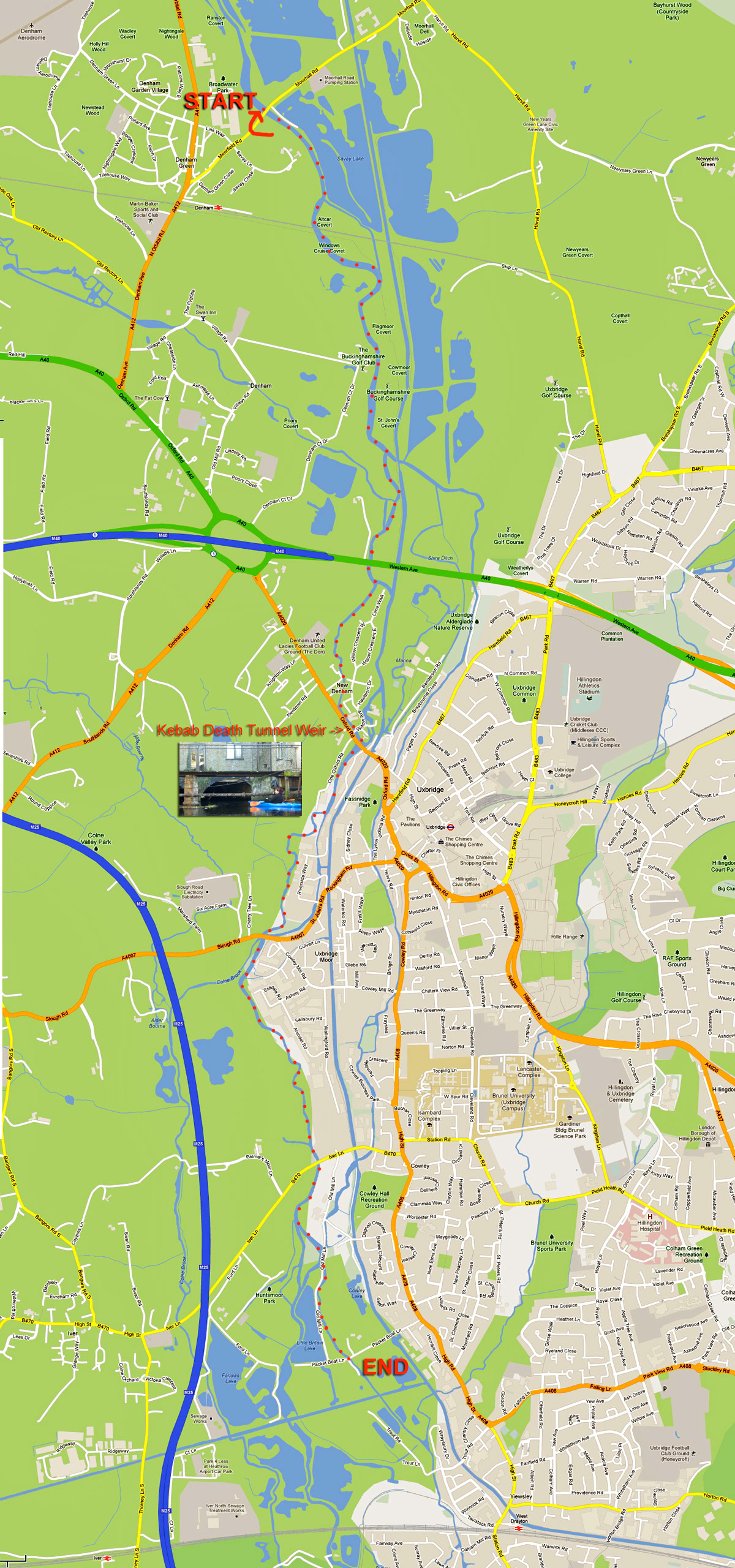
Looking at a map (far below) and more so at a sat image, it’s hard to distinguish the actual course of the Colne among the many waterways, reservoirs, overgrowths and the Grand Union canal which all fill this part of west London’s perimeter, but Lois had already recce’d a route which included half a dozen fun weirs and other challenges along the way – all up a run of around six miles. Chief among these tests was what must surely be an urban paddler’s nightmare; a weir drop inside a low tunnel that passed under a kebab shop and which we dubbed The Kebab Death Tunnel Weir (the word order is interchangeable). The thought of being spun in a dank, sunless hydraulic or jammed against a rusting grate as clammy kebab fat dripped onto your forehead from cracks in the overhead brickwork was surely the makings of a deleted scene from David Lynch’s Eraserhead.

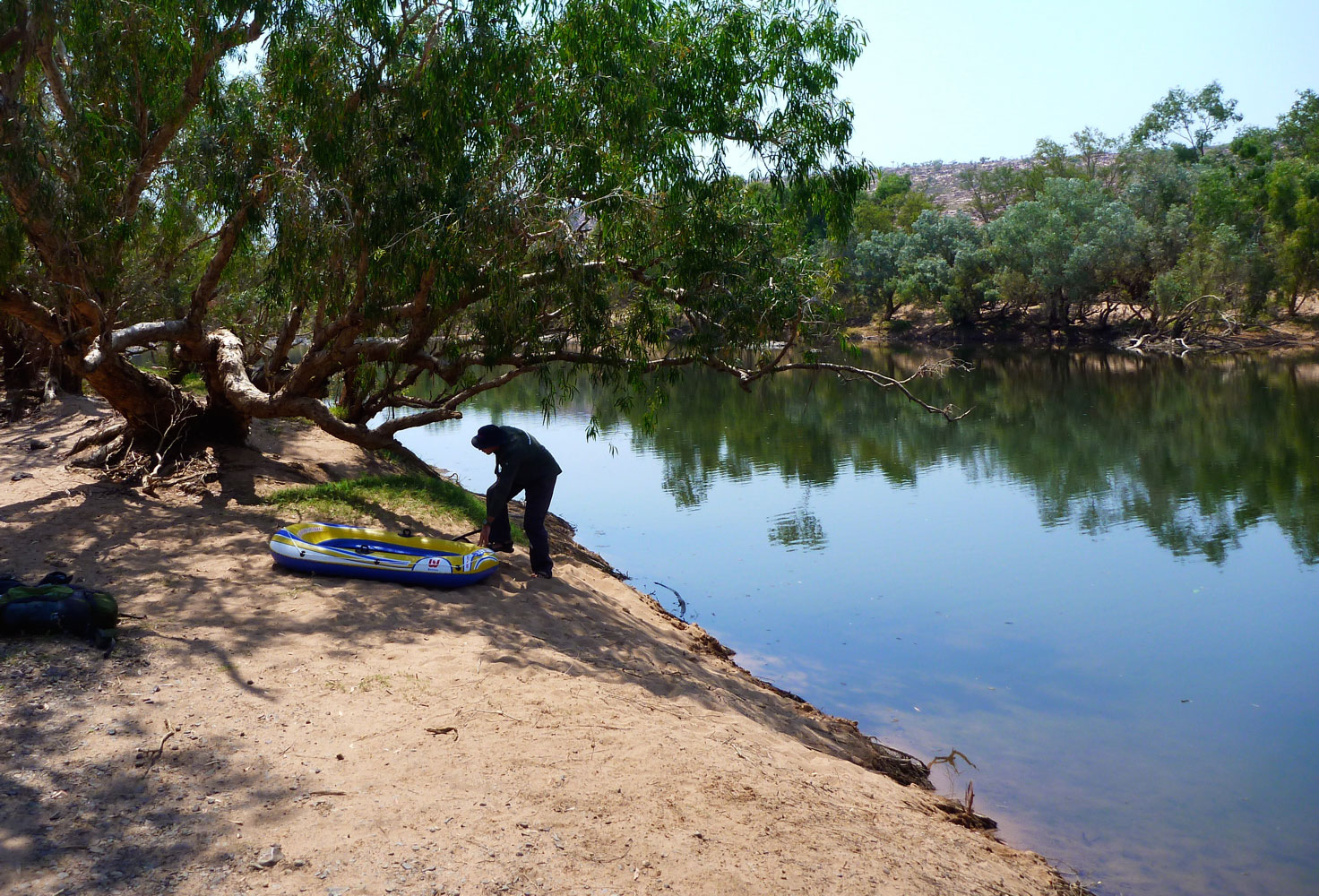
All that was far from our thoughts as we bundled over a bridge parapet and inflated Lois’ Sunny IK which Robin was borrowing. Lois was using her newish hardshell Dagger and I was in my Yak packraft. Lois quite rightly rationalised her controversial IK betrayal by explaining that as she lived on a canal she just wanted a boat to hop into anytime (her Gumos having sprung slow leaks). I can relate to that though I wouldn’t go as far as actually buying a plastic coffin.
We swooshed off under the bridge and downstream on a lovely autumn’s day, along what transpired to actually be a proper river with a kosher current, far from my expectations of a concrete lined culvert awash with urban detritus and pestilent scum. We passed under a huge arc of brickwork supporting the westbound mainline railway and soon sidled up alongside the Grand Union canal. Not that we could see it. Even the OS map gets quite confusing, marking rivers or other waterways passing across lakes and wetland reserves. But once on the river the way ahead was usually obvious.

At one point what looked like thick mat of giant watercress carpeted the river bank to bank (actually pennywort, a very troublesome weed I am informed). Up ahead Lois’ Dagger ploughed into the vegetation (left) which amazingly proved to be paddleable, although with my wide, flat-hulled ‘packa I found reaching out and tugging on the floating wortrug worked best.

Soon we came to our first weir, a drop of a foot or so but where we did the right thing and hopped out to check we weren’t tipping over onto some gnarly boat spike. All clear so Lois slid over effortlessly into some shallows, then Robin beached himself inelegantly on the rim in the possibly under-inflated Solar. Knowing this, I sped the Yak up to warp speed and scrapped over with a splash.

More riverine bliss ensued with barely a crisp packet to sully our glide. Delicate foot bridges led to cosy cottages. Another double weir looked deadly from above but recce’d from below was no drama. No having yet recognised the benefits of spray skirts, Lois’ Dagger was taking a cockpitful on some of these weir drops. The Solar too scooped up some swill, but this was the first occasion where I zipped on the Alpacka’s spray skirt – mostly to keep my legs warm but also proving it did what it was supposed to.

Up ahead, another clot of creswort choked the channel, but this had got thick enough to catch some crap so we hauled out stinky twigs and other rancid mush before hacking our way in. The rigid hardshell was best; my Alpacka (above) while broad was at least light, while the Gumboat put up a fight and Robin split his paddle all the better to dig his way through (right). Another weir with a drop of a couple of feet gave Lois a fresh rinse as we neared the outer London suburb of Uxbridge.


Bankside trees gave way to razor-topped railings protecting the back end of industrial units and things turned decidedly less serene as we neared the gaping twin maws of the Death Tunnel. It burrowed under a parade of shops, the pride of which was unquestionably the broad, handsome frontage of the Burger Kebab Galaxy restaurant.

Two limbo-low bridges lead to an even lower rusty sewer pipe spanning the canal, and up ahead two arches reached into the watery gloom like a farmer’s rubber glove and where the rank stench of congealed doner fat choked the air. A chink of light marked the far end of the 70-foot tunnel (left) where the roof – strung with electrical piping, rotting rafters and mummified bats – pressed down to just a couple of feet right over the edge of the drop. Lois said last time the water was higher and they couldn’t even see the end, but they’d edged in anyway, slid over and survived.

Even then, you never know when a burned-out scooter or half a tree might be poised to spoil your weir and anyway, Lois was sure this weir was higher than anything we’d done so far. So Robin and I clambered up onto the footbridge (left), walked round the far side and waded up into the tunnel as far as we could against the current. With the help of my camera’s flash I was able to get far enough in to see that the three-foot weir was actually a narrow 45° slide of about 3 feet, not a straight drop. Much less risky.


Now reassured that I wouldn’t be pitched out of the packraft to smack, face-first into to a span of festering, greasy brickwork, back at the boat I squeezed myself under the sewer pipe (right) and let the speeding current draw me in, making sure to keep well away from a broad side tunnel which led off to the right and didn’t look like it had a happy ending. I didn’t want to end up being squeezed out of someone’s kitchen tap like rubber-boned Janus Stark. In the main tunnel, the roof bore down and I stowed the paddle as I tipped down the chute, getting shoved against the right wall as I ran out towards the light like a near-death experience.

Lois came down next (faintly visible above left) and also got pushed right at the base of the chute and semi capsized.
Kebab Death Horror!
Her paddle floated down towards me but before I could grab it the eddy caught it and floated it back up towards the chute. Meanwhile, soggy arsed Lois hopped out and dragged her waterlogged Dagger into the piercing daylight. Robin came down next (left), got pushed over but kept it together. It seems the tunnel weir had set up a long, thin anti-clockwise circulant or eddy which came upstream and looped back down just below the chute and explained why we’d all got pushed into the right wall as we came off the slide.


But we’d survived the KWDT and soon cruised past a striking municipal bronze statue depicting a trio of naked nymphs grappling over a giant Christmas pudding (left), a scene plucked from the otherwise unexceptional Lost Chronicles of Uxenbride discovered not far from Kebab Galaxy in 1892. And here at last! A plucky South Bucks District Council dustbin uprooted from it’s roadside vigil and flung into the Colne by some beer-crazed revellers high on nitrous oxide. Now that’s what you call urban packboating!
There was more to come. What is a paddle in merry England without getting a bollocking from a vexed bankside angler. We’d seen a few upstream who’d mostly ignored us (I don’t waste greetings on anglers anymore), but as Robin and I rounded a bend following another weirlette, some grumpy git wearing rubber up to his neck let us know his feelings, concluding with:
‘You coming back?’ (demonstrating his lack of understanding about how kayaks and rivers interact).
‘No sirree‘
‘Good!’
His mate just down the way was more civil and explained ‘there’s no navigation on this beat, it’s in the agreement…’ pointing to a sign, rather ineffectively positioned downstream that merely said Private Fishing or some such. I didn’t know the paddling status of the Colne and maybe Lois didn’t either, but a quick Google later on showed up threads on the SotP and ukrivers that indeed suggested the Colne hereabouts had been leased by a bankside golf club to Uxbridge Anglers Club, and their £80 membership fee helped entitle them to exclude paddlers on parts of the Colne. What about the Magna Carta and all that? Which parts are off-limits is hard to determine unless there is a blanket paddling ban.
We certainly saw no ‘ No Canoeing’ signs so it all left a sour taste for a while, but that’s the way paddling is in England thanks to Edward the 1st’s short-sighted bequest to his loyal noblemen (or so the story goes).

The last mile or two down to Packet Boat Lane passed without rancour as the late autumn sun seeped through the falling leaves. The current was speeding along by now and negotiating a squeeze around a fallen tree and some brambles, Robin managed to low side the unskeged Gumotex at exactly the point where Lois had tipped in on a previous occasion. Luckily he was also in shorts and hopped back in the Solar. Somewhere here there was a blockage of fallen trees and flotsam which we couldn’t paddle through and so made our only short portage.
‘Take out, rrrrrrriver left!’ yelled Lois, scarring the crows into the flight path of several 747s lowering their landing gear. Incredibly, Packet Boat Lane (near Iver) is actually a drivable ford across the Colne, rated at no less than five stars by the peer-reviewed wetroads.co.uk.

Once back at Lois’ cosy houseboat Robin couldn’t resist nipping back and having a crack at the car-swallowing ford on his well-travelled trail bike. I stood in the middle with water halfway up my thighs and filmed the action, thinking, ‘rather you than me, mate – it’s a long push back to Crawley’. Sure enough, before he got even halfway his Yamaha spluttered to a stop and we pushed it back like a couple of spotty teenagers trying out their first stolen bike.
Back on the barge the throbbing woodburner and a hot bowl of soup soon thawed our chilled limbs as we tried to analyse what the heck was wrong with Robin’s moto, other than acknowledging an engine can’t run on water like a kayak can. We left Robin to it, I rolled up my Alpacka and rode back home across London.
Thanks to Lois P for organising a great day out.

Skinning the Sevylor slackraft
See also:
Slackraft river trials
Slackraft sea trials


As promised, I’ve invested in a Sevylor Caravelle PVC dinghy. Cost: £34 delivered complete with pump, oars, repair kit, manual in ten languages and a box which is bound to come in useful one day. The heavy-duty Super Caravelle model, as modified by Narwhal, is out of stock in the UK until next summer, although an Intex Sea Hawk is the same thing and can be ‘skinned’ of its outer hull (as in the graphic, right) in the same way to make a lighter, narrower and nippier ‘PVC packraft’ – see bottom of the page. That’s the purpose of what is being done here, in case you’re wondering.

Pre-skinned and rolled up, the Sevy was about the size and weight of a proper Alpacka packraft, but awaft with that dizzying scent of PVC which takes you back to Mallorca in the late 1960s. Fully inflated, it’s too wide to take seriously, but it stayed like that long enough to enable the outer chamber to be surgically removed with a bread knife. Unfortunately, it’s on this outer chamber that the half-decent ‘high volume’ Boston valve is fitted – all the rest (2 floor chambers and the inner hull) get poxy, beach ball-style push-in valves which, in the latter case, take a while to inflate due to the pencil-thin aperture. Perhaps the Boston can be grafted onto the inner hull; what’s the worst that can happen? I’ll find out soon enough as it also took so long to deflate the remaining hull by squishing the push-in valve I decided to cut it out there and then and slap on the Boston valve from the trashed outer hull over the hole (above left). This was the first time I used MEK solvent to clean PVC. This stuff is pretty damn potent and ‘cleans’ the PVC a bit like paint stripper removes paint! Tellingly, it’s also known as polystyrene cement and has uses for welding too, so use it sparingly on PVC pool toys or they’ll dissolve before your eyes.

The squidgey little foot pump (right) is very light, but slow, especially when trying to get enough pressure into the main chamber for the slide-marker to move down and line up with the ‘A’ on the SevyScale™ (below left). This is a pressure guide so you don’t burst your new pool toy – easily done with thin, stretchy PVC and sharp words. But by chance the Sevy valve plug fits neatly onto the end of my K-Pump which is much quicker at inflating. The Alpacka air bag sort of screws into the Boston valve too, but you need a K-Pump to get max pressure.

Testing the newly glued on Boston valve, the boat was losing air, but it didn’t look like the glued-on valve was at fault. As it happens the bath was full so a check revealed a tiny, half mil hole near one of the seams underneath. I’m fairly sure I didn’t jab the boat with the knife while skinning it, so it must have come like that or my carpet is sharper than I think. Lesson: test all chambers in your cheap pool toy before running a coach and horses through the warranty by attacking it with a knife – that’s if you can be bothered to send it back instead of dab some glue on the hole, should it also be faulty.
The oars are mere fly swatters as previously noted. It’s possible they could be joined together into a packrafting paddle, but why bother; there are decent Werners and Aqua Bounds under the bed so the oars can join the scrapped outer hull at the local dump.
It has to be said, once skinned it’s 36″ (91cm) wide, 60″(152cm) long, and no more than 12″ high at the bow, so there doesn’t look to be a heap of buoyancy left over for the likes of bloated boaters like me, but the floor also holds air unlike an Alpacka so a spell on a river will reveal all. As mentioned, if it’s enough to stop me sinking, I may invest in gluing a spare sheet of tough nylon onto the base. It may add weight but will make the Caravette unstoppable; that’s unless a sharp-clawed bird lands on the deck or it gets splashed with MEK.


With half a dozen attachment points cannibalised from the outer hull and glued onto the stripped-down packboat with some Bostik 1782 (right), it now weighs 1550 grams; about half the weight of my current Alpacka Yak and about half the volume once rolled up. So compact, it could even make a flat-water towing platform for the Yak – for carrying a bike for example, as I’m not sure it would so easily fit on the bow, especially with camping gear.
River trials will follow shortly, or I may well head straight out to Rannoch Moor for an overnighter with Intex chum Jon who lives up there – see the vid above from last summer. He has also been inspired to skin his SeaHawk 1 bloat into a purposeful packslab. Might be good to take the Yak as a spare up there; if Loch Laidon freezes up round the edges the ice spikes might be too much for our pool toys.
Slackraft river trials
Slackraft sea trials

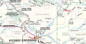
Packrafting Fitzroy – Gear
Fitzroy 1 • Fitzroy 2 • Fitzroy 3 • Fitzroy 4 • Fitzroy 5


Access
One reason I chose the Fitzroy was that it seemed easy and safe by Kimberley river standards. It was easy to get to Mornington; the river covered mostly flat terrain (no abseiling/clambering down waterfalls, etc); and it was easy to get off – either onto station land in an emergency – or at the end where it ran past Fitzroy Crossing.
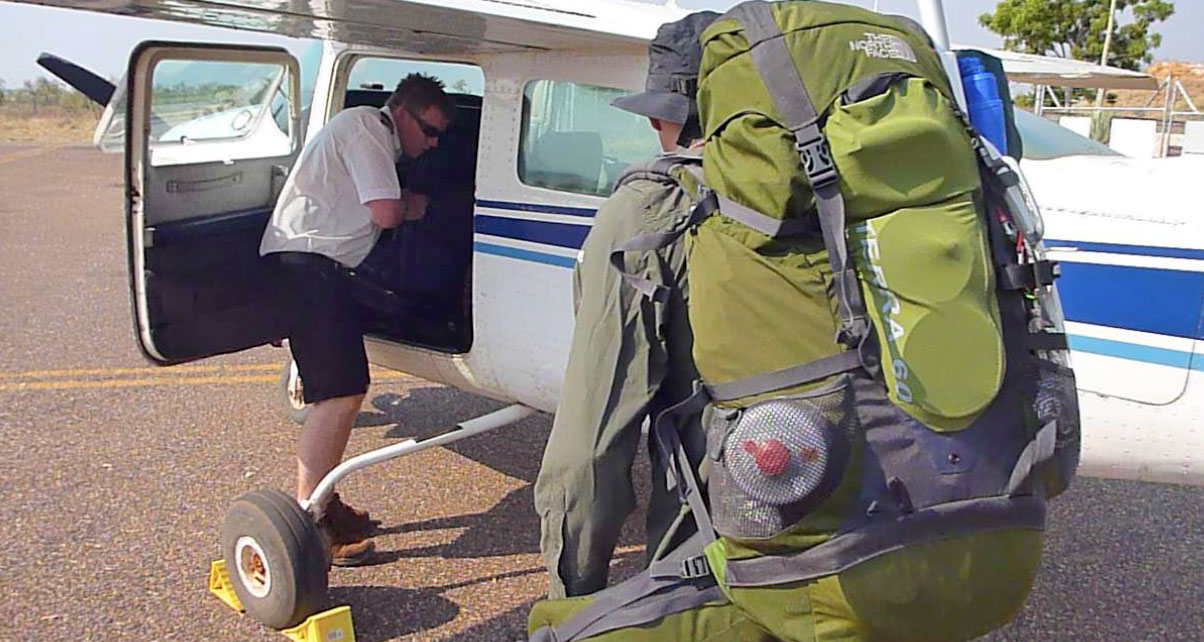
The Cessna from Broome Air Aviation cost AU$500 (£300), and we were able to leave Jeff’s van at Fitzroy Crossing aerodrome safely. The flight took 25 minutes to Mornington where we were met by a ute and taken to the camp. They charged us around AU$150 each for air strip pick-up and river drop-off, gourmet dinner and breakfast, and camping. Fossil Downs just asked us to call on departure and arrival (as did MWC), Leopold Downs (a small section) were not bothered, and we wangled our way through Geikie Gorge NP, as you read.
At the far end it was a 4km walk from the bridge through town to the aerodrome to retrieve the van. All in all, it couldn’t have been easier when you consider what we did, especially at the end of a trip when you can be tired or potentially lame or ailing.


Maps, Navigation and Comms
Three 1:100,000 scale maps covered out route and proved to be very accurate, considering the river channels can move around after a Wet.
Fitzroy Crossing 4061
Hooper 4062 (left)
Lerida 4162
Oddly, 4061 was printed on some kind of blotting paper and fell to pieces under conditions which the other two maps survived with a bit of drying. All maps needed the long-lat grid calibrated by hand along the sides to work with my GPS. They use some other (Australian?) grid which I suppose I could have set the GPS up to read, but I prefer what I’m used to: long-lat.


We both carried a GPS. I had a little Garmin 401 (left) and Jeff a more modern SatNav Nuvi with a good WA map which even depicted the course of the Fitzroy. He could have just about managed without a paper map. My 401 is a splash-proof wrist-mounted GPS, much lighter and less bulky than the 76CSx I normally use. Unfortunately, I suspect the 401 uses old Garmin electronics from the XL12 era that aren’t particularly sophisticated or efficient. The two AAA batteries lasted less than 6 hours (my CSX would have lasted up to 3 days in the heat on its two AAs), so after that I gave up keeping a GPS track and just turned it one to get a location. Because of that, we never really knew exactly how far we travelled. But above all, the 401 is handy and light, so as a quick locator it does the job unobtrusively and while it tracked it managed the splash-prone attachment to my pack without complaint. I sold it later – too basic for my needs.

I had a compass too but didn’t use it much, although my 10-year-old Thuraya sat phone was handy to call Fossil one time, or to liase with Jeff when he was still on the river at the end (his Ozzie PAYG mobile didn’t work up north).
Thuraya sat phones just about work everywhere except the Americas and are cheaper than Iridiums.

Food and water
We brought a week of freeze-dried, Pack n Go food from the UK (below left) which weighed in at 3.5kg each but didn’t cover lunch – just hot choc, breakfast cereal and a two-course dinner. Pour in boiling water, seal, wait a few minutes and you got meal. Although it became quite boring after a while and some meals are tastier than others, I was amazed at its ability to sustain us considering the energy we were expending for up to 11 hours a day. I probably ate half what I do at home merely bashing at a keyboard; I suppose the heat helped suppress the appetite, but it must have also been due to the food’s calorific and nutritional values.

In the morning we had a hot drink and a hot P&G cereal of some kind. Smoko (morning tea break) was tea and a muesli bar or trail mix while both lasted. For lunch I just ate a double cuppa soup (good for salt) and another hot drink – Jeff got to eating his evening pudding at this time. And in the evening we ate the main bag meal and I had my pudding as well as more tea, coffee and whatever. I can’t say I was ever hungry, but I sure enjoyed some real food when we got back to Broome – including the brilliant seafood curry down at the Wharf – you gotta go there!
We took my Pocket Rocket knock-off stove and a gas can but only used it on the last morning where there was no wood nearby on our sandbank. At all other times there was plenty of dry wood and little risk of a bushfire along the river bank. Out in the open during very windy conditions a stove would be less risky.

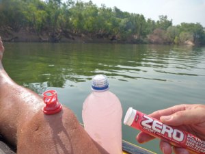
We planned to filter water daily with my Katadyn Pocket Filter (left), expecting lots of scunge due to low water levels. In fact the river was pretty full and running so after a day I dumped my cumbersome 5-litre water bag and filled a 750-mil bottle straight out of the river, while adding a Zero tablet (right) every time to stave off mineral loss through sweating. Jeff stuck with filtered (as did I on the day bat crap covered the river), and even though I didn’t use it much, I’m glad we brought it along,. There could have been an occasion where it would have meant clean water or no water, and out there you need water. Including drinks I drank up to 4 or 5 litres a day when engaged in hot and arduous portaging. Since sold and got an MSR Waterworks which I’ve not used yet.

Clothes
I expected to need to cover right up to reduce sun burn and transpiration: long trousers, long sleeves and a hat. But in the end while the UV was the same, it was not so hot on the river due to splashing and shade, and the trousers were only useful against big flies in the gorges on day one. The problem with long trousers is that when wet they cling to your legs and drag – Jeff eventually ripped his North Face zip-offs above the knee, but both if us turned to shorts and a bit of slip-slap-slop on our legs. Rolling up the trousers didn’t quite work.
Knowing they would get a hammering from the UV and all the rest, I invested in some American 5-11 Tactical trousers and jeans. They are basically the same as normal work or hiking trousers and shirts, but as far as I can tell feature a thicker synthetic material, countless pockets and other small details like tabs to hold up sleeves. The shirt was very good: huge pockets to take a map or whatever – both it and the trousers finished up fine after a rough week unwashed. And they both cost half of what Fjallraven and the like might charge. All in all, I am a 5-11 Tactical convert, even though I know it has a naff ‘special forces’ connotation. I didn’t find the synthetic material a problem in the heat with regards to rashes. odour and so on – if anything it dried much quicker and was tougher than cotton.

Footwear
We both bought some Brasher Lithium boots which were going half price in London (£65), as we expected a lot of tough walking with full loads. In the end there was very little of that – and just as well in the heat away from the river. The Lithiums were great when portaging/balancing over boulders and wading through slimy, rocky shallows. But in the sands they filled up with grit and were hard to drag out of quicksands where they filled with sand all the more. Jeff who did more walking than me, wore his Lithiums more, or his Tevas, but in the end we both went barefoot in the river: lighter feet, easier quicksands and more hygienic. By the end our feet were a little sore and swollen from rough gravel, very hot sand and twig jabs, but I think Jeff found his Tevas the worst of both worlds for catching gravel on his already sore feet while not giving full boulder support or secure footing. On the last morning he duct-taped his shoes to his feet (left), but that didn’t really work either. Around camp I wore flip-flops.
In the end, although lacing the Brashers up was a pain, you do need a pair of tough boots if you plan to be walking in the Kimberley – Tevas or Keen Arroyos will not do when packing a load. I poked drain holes in mine after a couple of days so my feet would not get sodden, but in the end it was better just to put them on when needed, even for a short portage. Teva Omniums much better.

Packs and camping gear
Jeff used my old TNF Terra 60 pack with dry bags, which was barely big enough but extremely comfortable. He also had a day pack which he clipped to the front – a neat system (right) for portaging. I used my UDB (90+ litres) and the Watershed Chattooga as a day bag (both left). But the UDB was a floppy sack on my back compared to the TNF and the Chat bag just got in the way for portages, so that went inside the UDB pretty soon and my shirt pockets became my ‘day bag’. I made great improvements to the stability of the UDB but packing the weight low one time. After that walking with it was not so bad, but it’s nowhere near as comfy as a proper backpack. But it can be if you use this.

I didn’t take a sleeping bag, just a thin blanket that was going spare, and wore all my clothes on the one or two cold nights. Most nights I used the $15 K-Mart Tent which Jeff bought me – more as a mozzie dome than against the cold. The K tent was too short for me but for what it cost it was OK. Since then I’ve bought myself an Exped Venus UL which pitches with just inner for hot, insect nights and is longer than I am. Jeff’s mozzie dome is the same sort of thing – just right for the tropical bush. I used my Exped Synmat DL which is excellent and sold,it to Jeff in the end who suffered under his Thermarest UK which I used to use until I woke up (too much). I’ve since replaced my cushy SynMat DL with the UL version which weighs just 500 grams and is half a litre in bulk.

Cameras and recharging
We both used Panasonic FT2 waterproof cameras – the ranger we met at Geikie had one too. At the time (before Olympus TG) it was good in that it’s waterproof (great for Ningaloo reefing) but of course the lens is tiny and so the picture quality- is not that hot, especially on zoom. The video quality, it has to be said, is pretty amazing for a £200 camera. We shot in Motion JPG and HD modes (not the AVCHD which doesn’t import so well I find). That gave a 1200 pixel image which is certainly good enough for youtube, even if it takes many many hours to upload a 5GB movie. I would love to have used my old TZ Lumix, or the even better LX5 I now have, but out in the wet and wilds it’s too hard to be careful with fragile gear so the FT2 is good enough until I get a commission from National Geographic. They’ve since brought out an FT3 as they do, with GPS and other gimmickry – there is no substantial improvement as far as I could tell and you’ll never get a decent lens in such a compact, flat, waterproof body. A pair of 16GB cards were more than enough for both of us.
We carried 1 spare battery for the Panas and, with the Go Pro below, that just about did us. In the end I didn’t take the Power Monkey solar charging gadget on the Fitzroy, but did use it on the Ningaloo stage. It charges the Pana batteries very quickly and has the capacity to do that about 10 times.
I also used my Go Pro which is temperamental and drives me nuts, but can get the hands-free shots other cameras cannot reach – mostly when on your head. The buttons are a pain so you have to check every time to be sure it’s on, but I also got into using it out of the box when the audio is of course much better. Out of bright conditions the exposure is not half as good as the Lumix; in the shade its terrible but maybe I should meddle with exposure settings which are on default. I also took a Gorillapod but that fell apart at the joints. Jeff used his newer one a couple of times; I’ll probably get another, maybe the bigger one for SLRs which may last longer.

Health and Dangers
The Kimberley can be a pretty unforgiving environment, hot, harsh and full of nasty or just plain irritating wildlife. I must say I feel I got away from there with barely a scratch; Jeff suffered a bit of crotch rot and cut up feet. I like to think that the Zero tablets I ate religiously kept me in good shape, even with unfiltered river water. I used a bit of 50-factor on my exposed legs and always wore the hat in the sun. In my experience in Australia the UV is much harsher than even the Sahara.

We saw no snakes – maybe one – though there are big olive pythons around (we had gaiters for walking in long grass, as Jeff did on occasion). Big lizards and freshie crocs are also only a danger if you tread on them by mistake. The only cow that got edgy was clearly in a bad way and cornered, and the only time big horse flies were a pain was, funnily enough, in the Leopold Ranges, well away from cattle country.
I think the biggest danger was portaging over boulders – a slip there could have ended badly once you crash to the ground under the weight of your gear. The answer is to pack carefully and take your time, or just do two trips as I did on one occasion. I found my packstaff was rather a hindrance with my boat on my head.
There were a few mozzies at night, but they were nothing compared to the blood suckers I’ve experienced in the Top End. So all in all, no drama.

Packrafting the Fitzroy 2/5
Fitzroy 1 ••• Fitzroy 3 • Fitzroy 4 • Fitzroy 5
The video above covers Day 1 (previous post) and Day 2 which is this post.
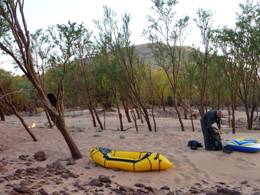


By 5am the sun had risen somewhere behind the ranges and it was light enough to get stuck into our first full day on the river. I’d slept well enough on the unrolled tent under a thin blanket and all my clothes. Some time around 3.35am a hot, phantom wind had blown through our sandbar camp from the northwest. I’ve experienced these lost night winds elsewhere in the desert and always wondered where they come from and where they went.
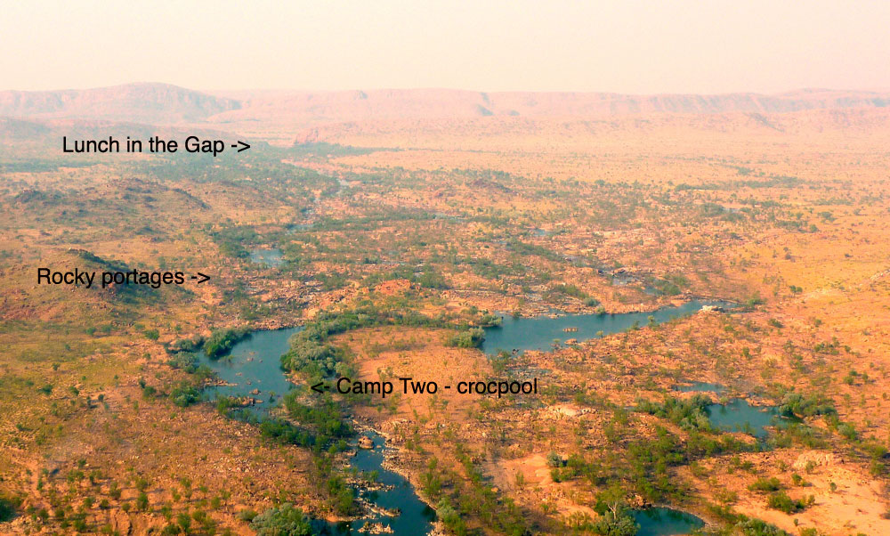
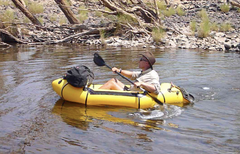
Like us, in the cool of the morning both boats were a little flaccid after yesterday’s exertions, but Jeff was relieved to find his Bestway was still holding good air. Even then, after a brief paddle he decided to walk the remaining five kilometres to Dimond Gorge. Me, I was pleased to stay on the water, even if it occasionally meant skating across slime-covered rocks when dragging the boat through shallow rapids (left). Right along the length of Fitzroy, another six inches water and just about all rapids could have been run in our boats, but I don’t suppose it works like that.

Jeff was now out of sight somewhere in the woods and soon enough the flow got shoved off the main channel by a blockage to burrow into the fringe canopy of trees where birds twittered and water monitors glared. This benign riverine underworld was a habitat I’d not anticipated, but was one of the most pleasant environments we found on the Fitzroy. Like a Damascene souk, shaded from the heat and glare of direct sunlight, you felt protected, cool and soothed while cockatoos squawked, rainbow bee eaters darted ahead and lanky-necked egrets stalked the pools. While pushing, pulling or paddling the boat through these cool causeways, I was reminded of that cool picture of Ed Stafford hauling his heavily loaded Alpacka through the Amazonian swamp.

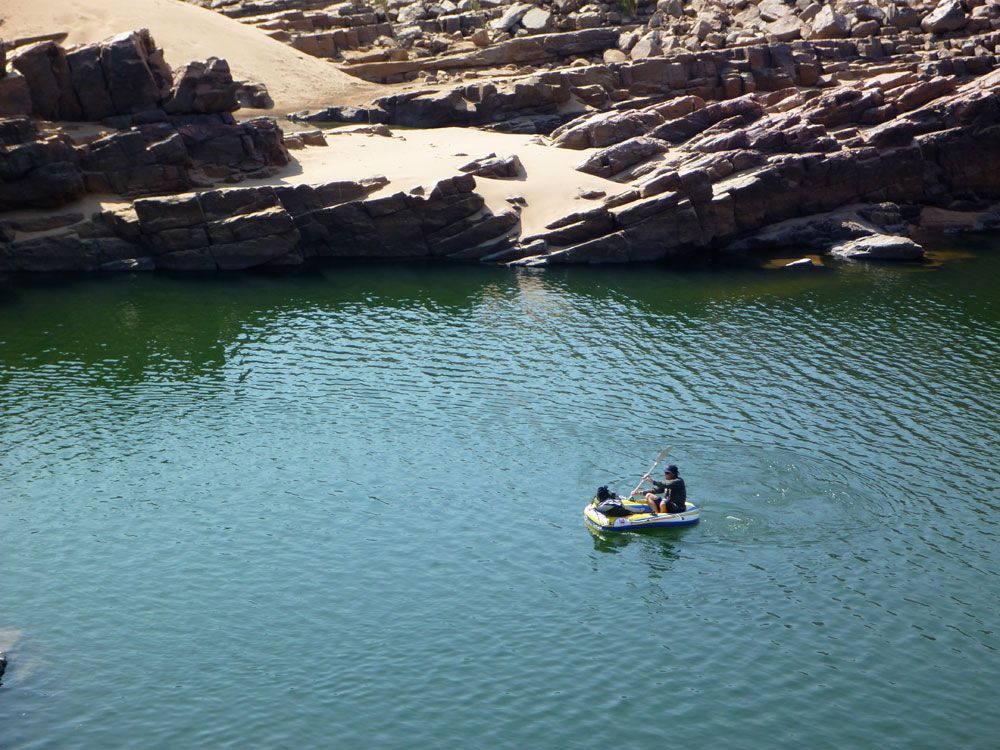
A couple of hours later I was back out in the open and squeezed the Yak between two rocks to slip into the top end of Dimond Gorge (above – downstream, and above, looking upstream). MWC left a few canoes here for day visitors and I pulled over alongside them, stripped off and dived in. Jeff turned up about 15 minutes later but it didn’t look like he’d enjoyed his bush walk and he simply dropped his dinghy in and set off along Dimond, knowing I’d catch him up soon enough. The headwind already funneling through Dimond from the plains didn’t improve his mood.

Presently the gorge turned left to break through the ridge and soon choked on the effort. It was here that the dam proposed over 50 years ago would have been sited, to match the Ord Irrigation Scheme near Kununurra in the East Kimberley. Although the idea gets revived once in a while, as things stand the Fitzroy is unlikely to get dammed here.

It was already 10am and with 8 or 9 clicks behind is, it was high time for ‘smoko’ as they call it in out here. As always, firewood was within arm’s reach and soon the billy was on the boil. We’d brought a gas stove in case high winds made real fires risky; on the way in from Broome we’d seen several roadside fires. Most were deliberate, late-season burn-offs, but we’d also heard some ultra-marathon racers had been trapped by a bushfire in a gorge on El Questro near Wyndham and had been very badly burned. If nothing else, it would be extremely bad form to start a bushfire on the station land we were about to cross, but we always lit up alongside the river where things remained damp and cool.

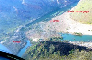
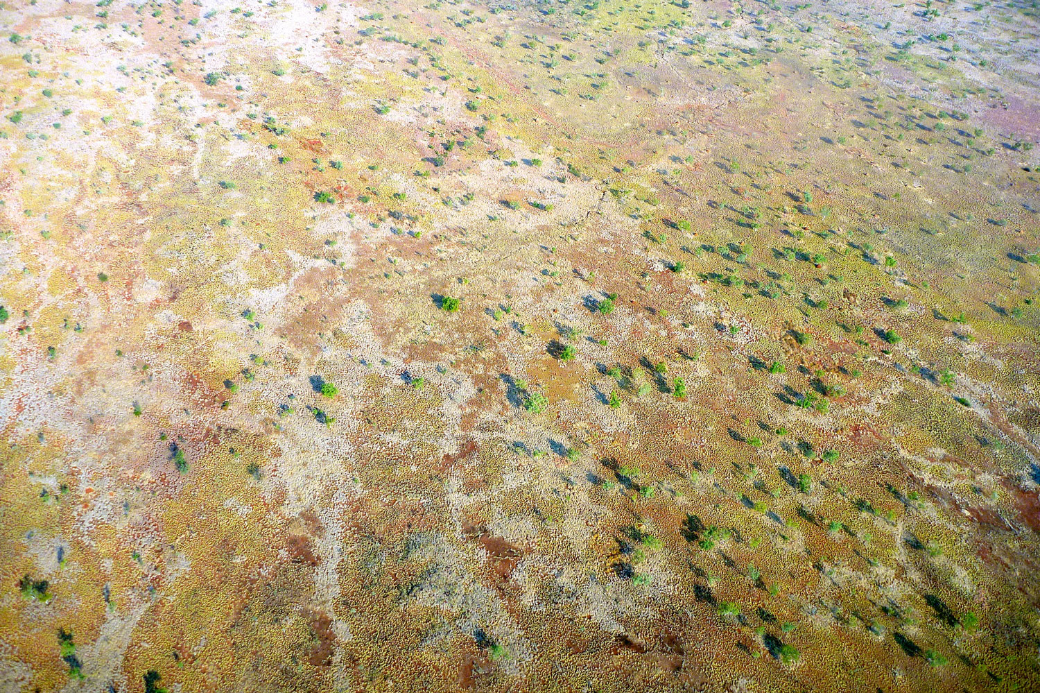
From this point it was about 6km to the next landmark – what we called the Gap, an opening in a low ridge like those found in the West Macs out of Alice, and which here marked the southernmost ridge of the King Leopolds. We’d seen it clearly on the flight in and with the headwinds persisting, Jeff decided to head off across the boulders while I paddled on for a couple of minutes, then portaged a very gnarly section. It looks like an easy 5-minute walk on the aerial picture but let me tell you with the head wind and my unstable pack, stepping between fridge-sized rocks with a boat under my arm was not a dance the Royal Ballet will be performing any time soon. At least the Brasher trail boots both Jeff and I had bought cheap in London were earning their keep here. Out of the shade and off the water, the heat bounced off the rocks, sapping the energy expended in carefully negotiating these rocky portages. I’d have to come up with a better system like Jeff, if these rough portages were to continue downstream.
I put back in as soon as I could, noticing we were now on granite, a little less smooth but also less coated in treacherous slime in the shallows, which made wading easier. Up ahead Jeff was putting in too and despite the headwinds held his own – clearly he was refining his Bestway paddling technique. As the conclusion of the video proves, Jeff was finding his pool toy to be more versatile than he’d initially hoped.
Another sweltering rocky portage led past some sort of sentry box and pipework river left, close to where an outlying airstrip lay on Fossil Downs land. It was a clear run from here against the wind to the Gap and the end of the ranges. We clambered onto a rock for a lunch of double cuppa soup and another hot drink. While the billy boiled Jeff threw out his handline; we’d been assured in Broome that the barramundi (northern Australia’s best know fish), would be huge so Jeff had bought a 30-pound line accordingly. But there was no fish for lunch on that or any other day while we were on the Fitzroy. They must be out there, but the only fish I ever saw where the size of my finger. It’s no wonder the crocs were so stunted.
Beyond the Gap we knew the river would change character as it weaved over the savannah for 60 kilometres towards Geikie Gorge. This would be the crux of the trip. Even though the flight had revealed several long and clear river channels, we’d also spotted masses of thick woodland with no clear path. We looked back at those aerial shots in our cameras to figure out the way ahead. Our goal that afternoon was to try and get west of 126°E and onto the next map sheet, something that in the end we only barely managed.

Soon after leaving the Gap we came to another big rock pile where the river braided out into nothing paddlable. In the mid-afternoon heat, clambering with all my junk was as much fun as roller skating on cobbles while balancing a sofa on your head, and using my packstaff for the first and last time was merely another encumbrance that threatened to impale me should I trip.
I desperately floated across the smallest pool, and when it came to the next big portage I simply left the boat and set off with the UDB pack. It took twice as long of course, but being able to see ahead and use my arms to balance, it felt safer. Perhaps it was hotter than we realised – getting on for 40° maybe? – but even before I turned back for my boat I was parched with thirst and croaked to Jeff, ‘Let’s camp at the end of the next pool’. Whatever the time was, we were beat!
The GPS was no longer tracking as the batteries lasted less than a day, but it turned out we’d put in an 11+ hour day of only 20 kilometres, managing just 5km after lunch. At our poolside camp, I slung the gear into the bank, went for a swim and then drank and drank. Unless I’d some acclimatising to catch up on, this effort in portaging over the big rock bars was not sustainable; fatigue would eventually lead to a mistake and Jeff had already fallen a couple of times.
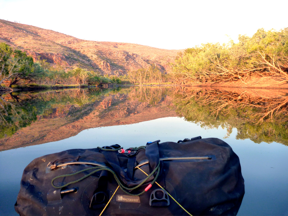
I needed to radically revise my portaging set up. My yellow Watershed ‘day bag’ was better out of the way inside the UDB which now sat in the boat not perched across the bow. That worked much better for wading and towing while I sat with feet plonked on either side in a suitably reclined paddling posture. Like this I could also access the UDB in the boat if needed, and forward visibility was better too while the Yak’s extended ‘fastback’ tail compensated for the rear-weighted trim. I’d also ditched my cumbersome water bag and now simply drank from the river. We’d brought my Katadyn and used it most evenings. Jeff stuck with it, but I found carrying a full day of water too heavy at the rate I drank it. I took care to drink from less skanky pools and flowing riffles and never got sick.

The water boiled and another two-course freeze-dried supper was wolfed down, along with several rounds of tea. Jeff was in bed by 6 – a personal best. It had been a tough first day and now we were heading into the meandering cattle lands we weren’t expecting it to get any easier as the river lost its definition. Jeff wasn’t convinced yet, but as I saw it, the key would be to keep track of the main channel and minimise arduous portaging at all costs by paddling or towing. Even then, we figured that as long as we didn’t get any more tired than we were tonight, and our once-daily bag meals continued to sustain us, we still had five full days of food for the remaining 100 kilometres and could trudge on at whatever daily distance we could manage until it finally ran out. By that time we’d surely be very close to Fitzroy Crossing.
It was a hot evening and out on the pool crocs, lizards or the elusive big fish were splashing about. I pottered around the camp for a while, putting off the unenviable moment when I had to squeeze into my too-short K-Mart tent to grab a mozzie-free night. I was still thirsty as I dozed off. Likely as not, tomorrow was going to be another tough one.

Gorges & Portages • Packrafting the Fitzroy 1/5
See also:
Slackraft Main Page
••• Fitzroy 2 • Fitzroy 3 • Fitzroy 4 • Fitzroy 5
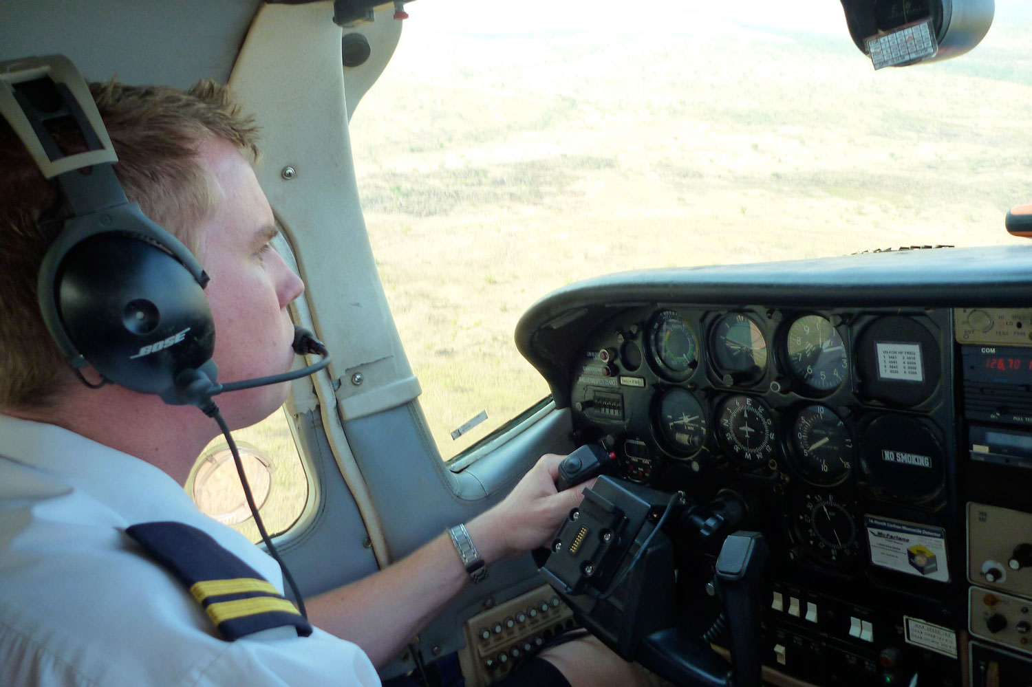
A few minutes after the plane took off from Fitzroy Crossing (see maps) Jeff taped me on the shoulder and gave a thumbs up.
A thousand feet below, things were looking promising. Sam the pilot had agreed to fly us low for the 25-minute run to Mornington Wilderness Camp (‘MWC’) as the direct route closely followed the river which we planned to follow back over the next week.

It was soon clear that thanks to a huge Wet season a few months earlier, there was a lot more water down there than we’d ever hoped for so late in the dry season. It could well be more of a paddle and less of a walk than we expected, and having missed out on kayaking the full Ningaloo a week earlier, I was feeling optimistic.

During the Wet season (Dec-March) when tropical storms converge or a cyclone dumps over its huge catchment area, the 700-km long Fitzroy River briefly becomes the largest volume river in Australia. Expanding in width from 15 metres up to 15 kilometres across the flood plain, the 13-metre-high highway bridge at Fitzroy Crossing gets submerged for days while log debris gets rammed in the upstream side of the parapet (left).

That’s the Wet. By the end of a Dry we were expecting the river to be a string of stagnant, fly-ridden pools necessitating tiring portages. Packrafts make great walking boats of course, but September wasn’t a great time for bush walking in the Kimberley as the enervating ‘Build Up’ (pre-monsoonal heatwave) was on its way. Still, this is the Kimberley, Australia’s pre-eminent harsh and remote wilderness just 15° from the equator so it’s hot up here most days. Thirty, 35 or 40°C – we’d just have to keep in the shade. It took a few months to research the Kimberley area, pin down a viable river there, and then narrow it down to a doable section where permission from the various landowners was most likely to be given.
Having got to know the Kimberley’s regular tourist spots as a guidebook writer, I decided our 130-km section of the Fitzroy was a varied but not over-ambitious packboating introduction to the region. Even then, permission from MWC was only finally confirmed the day I flew out of London, and for Leopold station on the day we left Broome.
The way I saw it in a post I wrote earlier, the key to packrafting up here relied on uncomplicated access and exit: fly in from a town or station airstrip and paddle back to it if you can. Rendezvous with helicopters or seaplanes could be left for more ambitious trips. Since I first started visiting the Kimberley in the early 1990s I’ve been planning some sort of bush walk out here, and now finally I was going to get my chance, thanks partly to the advent of packrafts.

If things went wrong on our river there were station tracks not too far off, from where we could get recovered inexpensively in a ute. And there was no saltwater crocodile menace up here, as there is on some north Kimberley rivers draining into the Timor Sea. Like the dammed Ord to the east, the Fitzroy flows south off the massif flows into the baking savannah plains of what are really the northern reaches of the Great Sandy Desert. It then swings back west and northwest to empty into King Sound at Derby, hundreds of kilometres later.
Salties can live in freshwater and can travel far inland during the Wet, but it was very unlikely any would be far upriver at this time of year. Much more timid freshwater crocs are commonly found in the Fitzroy and the nearby Lennard River at Windjana Gorge. We saw plenty on our transit, all bar one diving for cover on detecting our splashes. Although it sounds good for the yarn, freshies are no more dangerous than lizards or snakes, and swimming, wading or paddling among them is quite acceptable.

At MWC we paid through the nose for a gourmet dinner and breakfast, but one last ‘real food’ supper was worth it to save on our supplies of bag food. I’d checked MWC out for the guidebook years ago, but the place was really more of a wildlife sanctuary for studying Kimberley fauna; the upmarket tourism side merely covered its costs. Diane, the manager, was involved in an early morning finch census when we arrived, which meant she was unable to drop us off at the riverside until 10am next day.
We’d originally planned to put in at Sir John Gorge further upstream, but Diane advised that might involve several rocky portages. Dimond Gorge was the other obvious alternative, but that would flush us out of the King Leopold Ranges in an hour or two which would be a shame. So we compromised and got dropped off midway at Cadjeput Pool, all up about 133km from the highway bridge and 20km from Dimond. Cadjeput was at around 180m elevation which only meant an 80-metre drop to Fitzroy Crossing, but as we were soon to find, the river flowed there all the way.

Jeff was in denial over his $30 Bestway Outdoorsman 200 Sport pool toy, and who can blame him. He’d only paddled it briefly in the campsite pool in Broome to see how his load sat. Anything else may have risked a catastrophic rupture. But now was the moment of truth and on the river, paddling ‘backwards’, stern first (these boats are meant for rowing and so have the additional ‘sitting’ buoyancy in the rounded bow), his dinghy didn’t look like it was going to start a bushfire anytime soon.

We set off downstream along the tree-lined pool (right), but within half an hour came to our first rock bar where the river took a 90° turn to the southeast. It was to be a pattern we’d recognise all along the Fitzroy; any significant change of course usually meant a slowing of the current and the deposition of rock or sand into a blockage which the river either worked around or seeped through.

Already mid-morning and hot, unloading the boats and tramping with full packs for the first time (left) underlined how tiring and tedious this was compared to effortless gliding in a raft. Initially Jeff’s view was quite different; walking was preferable to slow paddling, especially as he’d worked out a neat portaging solution. By putting his paddle through the rollocks (picture below) he could position the paddle shaft between his backpack and his back which located the boat securely, made a great sun shade and, with a light headwind, even generated a little lift as he tramped along, carefully avoiding any low branches.


My own boat-on-the-head arrangement using my more floppy UDB as a backpack (left) didn’t work half as well in a breeze, especially while staggering over fridge-sized boulders. Over the coming days while Jeff was happy to walk, I took to the water as soon as I could, until I figured loading the UDB with the weight low when backpacking made it much more stable.
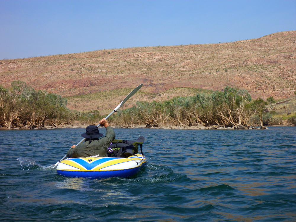
Back on the water, before us stretched a 3km-long pool leading to the next right-angle turn to the southwest around Fitzroy Bluff where a much longer 6km pool and a headwind really tested Jeff’s Outdoorsmanship. For at least two hours he span his paddle furiously while I slid along in the Alpacka. Just like Steve on the Chassezac in France earlier this year, Jeff tried various ways of paddling: sitting on the bow, in the boat, swimming from behind. Nothing could shift the pool toy at a satisfying speed short of wearing it as a hat. It sat on the water like a jellyfish in a coma, and with the GPS I measured it running at up to 3-3.5kph while I topped out at 4.5-5kph in the Alpacka. And even to achieve 3kph Jeff had to paddle at twice my frequency, while failing to get a good catch due to the BW’s added width.

The Bestway really isn’t the best craft for touring big Kimberley rivers until you appreciate it costs less than a night’s camping in Broome or five overpriced beers at the Potshot Hotel in Exmouth. I was already wondering if Jeff would stick it out as pushing his water sofa into a headwind clearly ate him up. It was a mild reversal of the situation on the Ningaloo a week or two earlier, although being in the slower kayak there didn’t bother me as much as its handling in the high winds; you’re as fast as you are and here on the Fitzroy the reduced pace suited me just fine. I wouldn’t wear myself out and anyway, I was sure it would take us a day or two to establish an equable travelling pace. Could I carry on alone if Jeff bailed at Dimond tomorrow? What if he damaged it beyond repair and walked on while I carried the packs on long pools. Would that work? All options were on the cards for the coming days

At the next blocked bend I lifted over some logs and took off down a cool, canopied channel (left) while Jeff loaded up to haul over the sand and rocks. At the start of the next pool there was no sign of him, until backtracking on foot and shouting, I found he’d somehow got around me onto the far side of the channel.


In his exhausted haze he’d wandered up a side valley and only realised his mistake on turning on his Garmin Nuvi which had unusually good mapping, even out here (only I carried 100k paper maps). At that moment he looked rather shell shocked – I’d not seen him like that before. Just after the next shallow rapid an inviting sandbar glowed in the late afternoon light. ‘Let’s camp there‘ I pointed, and to my surprise he simply agreed; a mark of how tired he must have been.


We’d covered what I now realise was actually a pretty good 16km over about 7 hours, much of it into a valley-funnelled headwind with little shade and with no food breaks. We’d eaten our fill at Mornington, but that was going to have to change as we got to put in full days on the river.

A fire was easily lit and soon we tucked into the first of our freeze-dried bag meals followed by several cups of tea. By 6.30 it was dark and Jeff had already passed out in his mozzie dome after admitting ‘This is going to be the hardest thing I’ve ever done‘.
The video from this day is on the next post.

Kayak and Packraft Sails

Packrafting on Inverpolly

A sunny and a warm day, so although I was still feeling a bit groggy following a cold, it was high time to enact a mini-packplan: head out to Inverpolly and string together some of the lochans on the west side.
I’d nipped out there a few days earlier to check the lie of the land and try out some used Jungle boots, and although the maps warned of sluices, it all looked doable from the hillsides above.

And judging from the terrain I crossed to get there, it would be a whole lot easier to paddle than to walk. At the end of this paddle my shins were all scrapped bloody by dry heather stalks and other brush. Some sort of plain canvas gaiters are needed to walk across this stuff, even in long trousers. More gear… sigh.
The Mrs had nipped off to Handa Island with the car, but it suited me fine to cycle out to the lochans by the fish farm on the WMR to Lochinver. I stashed the bike behind an old shed in the woods and walked on up the road.

Loch Call‘ where I’d chosen to put in isn’t visible from the WMR which explains why I overshot it a bit, but a splash in the loch to cool down followed by paddling to the north end lined me up for the path down to Boat Bay. It’s one of only two paths I know of to access the lochans. But why were my arms so weak? it was only a cold for goodness sake! I decided to scoff all my sandwiches in the hope it was food I was needing.

Paddling out of Boat Bay the wind was firmly at my back and I sped along at an effortless 3mph+, and noted no ‘weathercocking’ (back end swing-round) as you can get with a kayak without a rudder or skeg. A packraft is a whole different thing of course, with all the weight in the back. If anything, going into the wind sees the lighter front come round if you stop paddling briefly.
That same 10-15mph wind that pushed me along would probably be in my face when I turned the corner into Loch Sionascaig (above) and headed southwest, and sure enough it was, but not enough to spoil my day. The sandwiches were kicking in by now and I shovelled my way towards the first sluice, surrounded by the three mountains of Stac Polly, Cul Mor and of course Suilven, which give this paddling location it’s unique character. How wonderful it is to be out here in the wilds, fanned by a warm breeze and for once not being chocked from all angles in faux-breathable, latex-trimmed wet wear. This could almost be France or Scandinavia in a heatwave.
First one, then a couple more fishermen cropped up, standing alone on the banks, dipping their rods and exuding the usual unfriendly vibes. How did they even get there, I wondered? Not looking intrepid enough to have tramped over the hills, they must have paid their dues and been dropped off by the Inverpolly Estate’s boat from Boat Bay. Then a bloke comes round the corner paddling a yellow inflatable bath and threatens to put the wind up their trout.


I neared the sluice (above: from above; left, from the south) at the southwest corner of Loch Sionascaig. On my Suilven overnighter a few weeks back, I’d noticed something white hereabouts while on the way back to Boat Bay from the north side of Sionascaig. Turns out they were just big white bags of rocks left over from shoring up the crumbling sluice wall. Most of the water pours though holes in the wall but even then, considering the size of Loch Sionascaig, there’s no danger here of getting sucked into anything nasty at normal levels. Should the wall fail, that could be another matter.

It’s about a 10-metre drop (above) into the steep-sided Loch Uidh which leads to a gap. Here as expected, the wind was funnelling but was counteracted by a slight current running my way. This soon ended at another crumbling sluice that might have been runnable (below).
I came right up and had a good look but decided the raft was too wide to make it down the chute and one-foot drop without me making a mess of myself, and I had to get out soon after. So I walked round and down alongside a series of torrents to the last paddle, Loch Na Dall. This happens to be linked by a short car track to the WMR (not on the map); a good take out if you’re in a canoe.

 Although I’ve read of canoeists paddling the slim lochs below Suilven, portaging over to Loch Sionascaig and hoping to follow the Polly all the way to the sea at Polly Bay, what follows from Loch Na Dall isn’t really worth the portage, even if you’ve had a great time up on the main loch. It’s an ankle-twisting haul on a bumpy paddle all the way down to the fish farm, and the one kilometre downstream section after the road bridge at the fish farm (sluices and strainers) to the sea may well raise frowns from the Estate. But perhaps in winter, with the higher water levels you’d need for a clean run, no one’s bothered. Anyway it pays to remember: this is enlightened Scotland where outdoor access is a legal right, though always best combined with common sense. I’ve spent the last couple of months enjoying this freedom up here so it’s worth spelling it out:
The Land Reform (Scotland) Act 2003
“You can exercise these rights, provided you do so responsibly, over most land and inland water in Scotland, including mountains, moorland, woods and forests, grassland, margins of fields in which crops are growing, paths and tracks, rivers and lochs, the coast and most parks and open spaces. Access rights can be exercised at any time of the day or night.”
Back to the packrafting. The south end of Na Dall was asprout with grassy reeds which created a briefly exotic paddling sensation. At it’s end the river dropped down into the valley, but there was no tell-tale roaring and the contours on the map suggested it didn’t drop immediately. So after peering from the intake, I dived in with blades churning, only to get hung up on a rock at the first drop. Free from that and on the move, the underside of the plucky Yak whined periodically as it slid over successive obstructions; another high-centred hang up, another clumsy, butt-pivoting, paddle-bashing extraction, gaining nul points for style.
That led to a breather in a pool and then another frothing drop, the camera by now sagged from the jolting. It had turned out to be a couple of minutes of unexpected action, but up ahead there was that ominous noise and I knew it was time to hop out ahead of a series of stony drops (below). I rolled up the Yak and tramped back down to the valley and the bike shed.

Riding back over the hill to Osgaig Loch at a quarter of the speed I came down it earlier that day, there’s a hoot from behind. ‘What!?’ I snapped, eyes stinging with sweat. Another hoot ‘WHAT!?’ Ah, pardon me, it’s the g-friend back from Puffin World while I’m puffing away in two-one, as red as a puffin’s beak and as sweaty as a sauna full of guillemots.
‘Want a lift, puffinboy? You look a bit hot‘.
I was actually anticipating the freewheeling rush down to Osgaig Loch where I’d had half a mind to try rafting the bike over to the other side. Never tried lashing my bike to the bow of my packraft before – it seems an awkward thing to strap down securely, but others have managed fine so it needs trying out once. Something for another day. We hooked the bike up and drove home.

Packraft to Suilven Mountain

Anyone who’s climbed up the fin-like ridge of Stac Polly will see a wild, lochan- and bog-speckled vista spreading north across the Assynt. Just a couple of miles away are the peaks of Cul Mor and Suilven (main hill, left), relics of a glacier that ground down the land between them as it inched towards what’s now the sea.
The OS map shows this area as a Nation Nature Reserve, but it actually lost this designation a few years ago. And although it looks wild – so wild there’s no grazing, nor inhabited dwellings – this 100 square-miles of barely-fenced bog, rock and water is unusually accessible, bordered by quiet roads to the south and west, the A835 to the east, but not much to the north apart from the path passing below the north slope of Suilven. So seeing as this region of Coigach/Assynt has so few packable rivers, these lochans are a great place for short-range packraft exploration following some of the routes suggested on the graphic, right. It’s not just me that thinks so, the local sea kayak outfitter as well as a couple of intrepid canoeists have been coming here over the years. For them the inter-lochan portages require some commitment. But not in a packraft!


You can make up a route to suit yourself here; climb every mountain, ford every stream, visit every island. I chose a pretty easy overnighter and got dropped off by the road at Linneraineach below Cul Beag. There’s nothing at Linner’ bar a footpath which leads north to Loch an Doire Dhuibh (right viewed from Cul Mor).

My packplan was to paddle across Doire into the small adjacent loch, follow the channel into the main Loch Sionascaig, pay a visit to Eilean Mor, the biggest island hereabouts (and one of hundreds of Eilean Mors – or ‘big island’ in Scotland). From there I’d paddle among smaller isles towards the northeast shore of Sionascaig and walk past the ruin of Shieling over the saddle to the short river that links Fionn Loch to Loch Veyatie. With a paddle over to the south side of Suilven mountain, I’d find a dry spot to camp and take it from there. Suilven is only 731m or 2398 feet high, but it does have a strong draw on the imaginations of hillwalkers in far northwest Scotland, as do many of the Assynt’s peaks.

I think much of it stems from its Ayers Rock- or Matterhorn-like separation from its surroundings; a distinctive mountain shape, like the much more accessible Stac to the south. Add the lochans below and the open sea just a mile or two away, and mountain summits around here add up to something special. The picture right is taken from Ben Mor Coigach (743m) looking north over to Stac, Suilven and the distant peak of Quinaig. That’s another thing – the mountains have nice names around here with, you’d like to think, a touch of the Norse about them. This is after all Sutherland, or ‘the South Land’ in the mind of a Danish bloke in a horned helmet, circa 900AD. If you like hills there’s a panorama of some Sutherland mountains below, taken from the tip of the Coigach peninsula looking northeast.


Back to the boating; this was my first proper run in my Yak and as I pulled smoothly away from the shore of Loch Doire (left) it struck me how cool it is to trek over the hills with a pack of only 10-12 kilos, inflate your mini boat and set out across a body of water with your kit slung over the bow. In fact I’m convinced a frontal load makes packrafts faster as, despite the wind drag, the weight reduces the left-to-right yawing.

Very soon I was surprised to see the GPS reading a steady and sustainable 3mph (4.8kph, 2.6 knots) on the calm, windless loch. “What’ll it do?” I wondered, as you do. About 4.1mph, as you ask, but only for a few seconds, unless there’s a Great White on your tail. I’m sure that was more than I ever registered in my old-shape Llama, and I dare say more than I could average walking along the surrounding terrain which was mostly pathless. When I got back a speed graph (right) extracted from the GPS spelled it out: tramping across the pathless hilly bogs – about 2.3mph; on the water, out of the wind – 3mph; on the water into the wind – 2.4mph but with some effort.


The channel that led west to Loch Sion (below Stac Polly, right) looked promising on the map, but even with the current high water levels following the deluge that was May, it soon got too shallow over the couple of metres drop to the next loch, and with a wince-inducing scrape the Yak hung up on a rock, requiring a short portage (left). That done, moving out onto Loch Sion a breeze was now in my face as I edged along the shore. Past Eilean Dubh I squeezed through another inter-island lead and out into the main loch, heading for Eilean Mor island. Even with the mild buffeting, it struck me how safe I felt alone in my raft; safer than I often feel initially in my Incept kayak at sea in similarly tame conditions. I think not being at sea had much to do with it, with no kind of wave or ill wind that could blow the Alpacka out to the wrong side of Greenland.

Eilean Mor is a natural focal point in Sion loch – what can it be like, an island set deep within in a wilderness? Many paddlers are fascinated by these tiny wooden islands on Scottish lochs, I assume like me, because they think it must be a UNESCO-like example of a hyper-pristine natural habitat beyond the reach of prolonged human intrusion.

On the southern tip I can tell you there’s certainly a spacious, grassy camping spot (and now, a finely-built cairn), but as I half fell out of my boat and staggered ashore (left), the latest shower passed by as I beat my way inland towards the Eilean’s summit, through a forest choked with ferns, birch, hazel and their fallen, decaying predecessors. As I bushwhacked upwards, an owl not 10 feet to my left flew off noiselessly, and in places the ferns hummed with a flouorescent green glow (above).


At the summit, about 100 feet above the loch I looked over to the entrance to Boat Bay, a mile or so to the west (above left). To the north Suilven was a dark, uninviting rampart while to the south I imagined the walkers who daily take the short trek up Stac Polly (right) looking down on the progress of the little yellow boat far below and thinking, heck that looks fun!

I set off northeast, passing other inviting but unnamed isles (left and right), around Rubha Sionascaig with its alluring isthmus and up to Creag Sionascaig. Arriving at the shore, new shoots of grass poked through the blackened peat, scorched by the bushfires of early May which have been well and truly doused by the series of lashing gales which followed. I rolled up and headed up a creek line towards a saddle, passing a ruined croft which, as in so many remote locales in northwest Scotland, makes you wonder what on earth the people lived off up here?


Squelching over a novel mixture of burned peat crust spongebog mush (left), at the pass I looked down and saw half a dozen tents and a couple of canoes (right, barely visible) pitched at a meander in the river at a point where it was quite probably fordable. I’m sure the water there was running eastwards from Fionn into Loch Veyatie [it doesn’t], but if that’s the case then Fionn Loch is unusual in that it drains both ways, east and also west via the River Kirkaig to Lochinver and the sea. A geographical oddity? who knows [I do now; it isn’t]. I walked directly to Fionn, deployed the Yak and paddled across the channel (left). A short walk out of sight of the campers found a flat shoreline where I pitched beneath the looming mass of Suilven.


At times I’d wondered whether there even was a path up the south side of Suilven mountain (left) – I’m sure I’d read it somewhere. Then, during a short spell of sunshine a steep path became briefly illuminated; straight up alongside a scree slope, then off at an angle to the saddle-ridge between the two peaks. But now it was raining steadily, I was pretty damp and not in the mood for a hefty slog across contours pressed together up like the teeth of a comb, but I feared once I got in the tent I’d probably slob out. So after a light feed, I set out, packstaff in hand, to locate the path up the hill and once on it, followed it till 8pm. If nothing else, it was a good way to warm up and dry off.


It would be nice to report a stirring vista some 400 metres below the summit of Suilven, but a leaden gloom pressed down on the sodden land. I’d called the Mrs – tomorrow would bring more rain, but the winds would return too first thing in the morning. Back in the tent and soon after sunset, the rain arrived early and lasted most of the night. It was all a bit much for my single-skin tent which, though amazingly light and compact, is not rated as waterproof. The drips soon came through the fabric of the flat roof as I dozed, soaking my legs and chilling me. Half-awake, I lay my cag over the drip zone, after which the night passed well enough and I woke reasonably dry.
The next day was not one for shorts; today I was going to try out my new Kokatat Swift Dry Pants (see Suilven Gear). I’d half a mind to catch the twice-daily bus at 11.15 from the junction (see green graphic, top of the page) and estimated it would take 4 hours to get there, so breakfast at 6am was cereal in warmed up loch water. It wasn’t raining yet which meant it would be shortly, so I packed up quick and scooted back over Fionn Loch, taking a different route back southwest, past Na Tri Lochan to an inlet on Loch Sion (see satellite image bottom of the page). It was a longer land stage, but would put me into a better position to dodge the predicted southwesterlies while paddling back west towards Boat Bay. I’ve been reading a lot of sea kayaking literature lately and the lessons were paying off.
Let me tell you, walking over the pathless mire following a night of rain is merely a necessary means to get to the next bit of fun paddling. My knee-high Seal Skin ‘Wellington socks’ were working fine – last night my feet had been bone dry – but it’s a tiring, rhythmless slog over this crap; any sheep trails are merely conduits for more running water and mud. Again, the star of the Gear Show has to be my packstaff; it makes walking on uneven ground, descents and climbs so much more secure, especially with a load.

I reached the inlet bang on time which took me by surprise. Was this some un-noted lochan, no it was Sion – I’d not read the inlet’s shape on the map closely enough. Once back on the water, initially my leeward paddling ploy worked well. Then I turned a corner and suddenly the wind was onto me and the bow was bouncing on the waves (left) as I hacked past the shore at barely 1mph. For a while I thought I’d have to give up and take to the shore but again, as sea kayaking lore states, wind is often exacerbated round a point or headland, even on a lochan. Near normal speeds resumed, in fact just a fraction under the still-and-calm 3mph cruising of yesterday, but at a heavy cost to the arms and shoulders. I couldn’t have done this all day but luckily, I didn’t have to so I got stuck in. Again I was surprised how safe I felt out here, alone and ill-dressed and where stopping to fiddle with the cameras pushed me back nearly as fast as I paddled forward.

Finally I entered the mouth of Boat Bay, back onto known ground. The end was in sight. Last September I couldn’t even paddle the Sunny out of this bay in a stiff easterly. Now I dug my way onwards to the tiny beach inlet which was notably smaller than last year. I rolled it all up and hiked up to the nearby road. Within a couple of miles g-friend’s hatchback popped over the hill and I was home and dry for lunchtime – a 15-mile, 24-hour mini packboating adventure completed, with lots more ideas for future exploring of the lochans below Suilven mountain.
Below: almost the entire route seen from Cul Mor summit, looking southwest and west. Stac and Summer Isles in the distance.

