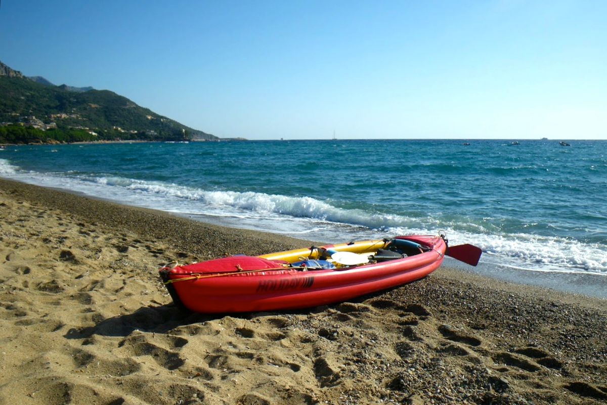
The Seawave was released in 2013 and in 2016 a near-identical model came out with a rudder option. The Seawave can be used as a single, double or triple, and is sold in Euroland for around€1625 or £1425 in the UK. They used to be a bargain. Not any more. In 2023 the Seashine version came out – a Seawave with a drop stitch floor (like the Thaya and Rush); slightly heavier, wider and longer and a lot more expensive.
My stats for my Seawave are 4.5m x 78cm wide and 17kg plus a claimed payload of 250kg which sounds plausible. Significantly, the Seawave’s pressure is rated at 0.25 bar (3.6psi) all round, midway between the Gumotex IK norm of 0.2 and Grabner’s 0.3 bar. Some of Gumotex’s orange series whitewater boats run 0.25 and their IKs were never that shoddy. Having said that, the PRV in the floor of the Seawave has the same ordinary rating you’ll find in a Twist or a Palava or probably any other Gumotex IK (more here) but the adjacent sticker claims 0.25 bar max. It’s the side tubes that now take 0.25 bar, not 0.2. What they now call Nitrilon is not like the stiff old hypalon-like Nitrilon of my early Gumboats. Increasing hull pressure is one way of getting a more rigid and therefore faster IK, but it’s the integrity of the ‘I-beam’ floor that’s the usual limitation. The Seawave has a pressure-release valve in the floor but not on the side tubes, and I read these pressures are said to be on the conservative side. You can’t over-inflate the floor but these Gumboats can handle more in the side tubes providing you watch it when out of the water in the heat.
The Seawave is long for an IK, but with just a skeg (optional, but there’s a rudder now), you wonder if this could be hard work to turn into the wind. However, in France kayaks destined for sea use (beyond a certain distance from the shore) must be homologated or approved in some way, and the Seawave has passed this test.
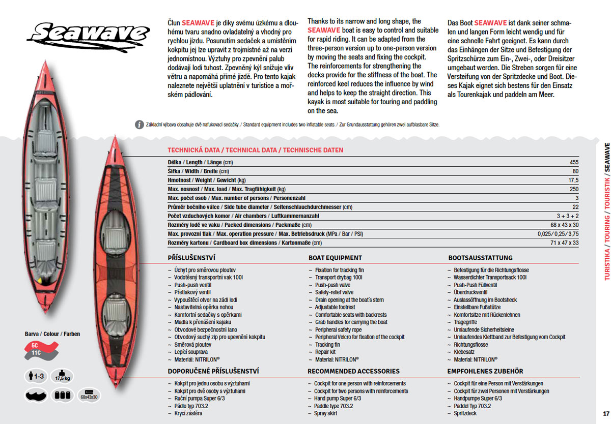
The great thing with the velcro deck (for one or two) is that it can be removed; on my Incept I paddled like this approximately 99.9% of the time, with the deck rolled to one side. Even at the slightly higher pressures, I have to say at one point in the video I noticed the Seawave bending with the swell. My Sunny used to do this, taking on water over the low sides, but with a deck that ought not be less of a problem, even if you imagine there’ll be some seepage through the velcro in heavy conditions or white water.
Flexing is a problem with any long inflatable and even my short and high-pressure Grabner (left) flexedin certain conditions. Manufacturers get round it with metal frames (Feathercraft, Advanced Elements), twin side tubes (some Grabners, Gumo Seakers, Incept) stiff fabric (Incept) or just high pressures like Grabner, but that demands very good construction. Drop-stich panels are the new way of doing it now.
There are more impressions as well as some nice pictures from an actual owner, Norman, right here (translated from French). He ran a 410C for a few years and talks of pumping his Seawave right up to 0.35 (5psi) bar which makes for good speed (6kph average he claims). That is 40% above the recommendation so let’s hope the seams on the Seawave can take it, cap’n.
It looks like grey, Halkey-like valves in the back, not the old-style black ones that Gumo used. And I see that Gumotex have again adapted an idea that I had on my Sunny years ago (right), a drain hole at the back. Only theirs features a neat sliding cover. It could all be the normal process of improvement of course, but I recall that after I had some smaller skegs made for my Sunny (and sold to a few others), Gumotex reduced the size of theirs to the current black plastic ones. And then the velcro deck idea. Whatever, it’s gratifying to see ideas I have tried or written about actually making it into production.
Enough of this speculation! Actual impressions on receiving my boat here, followed by half a decade of very enjoyable Seawave paddling.
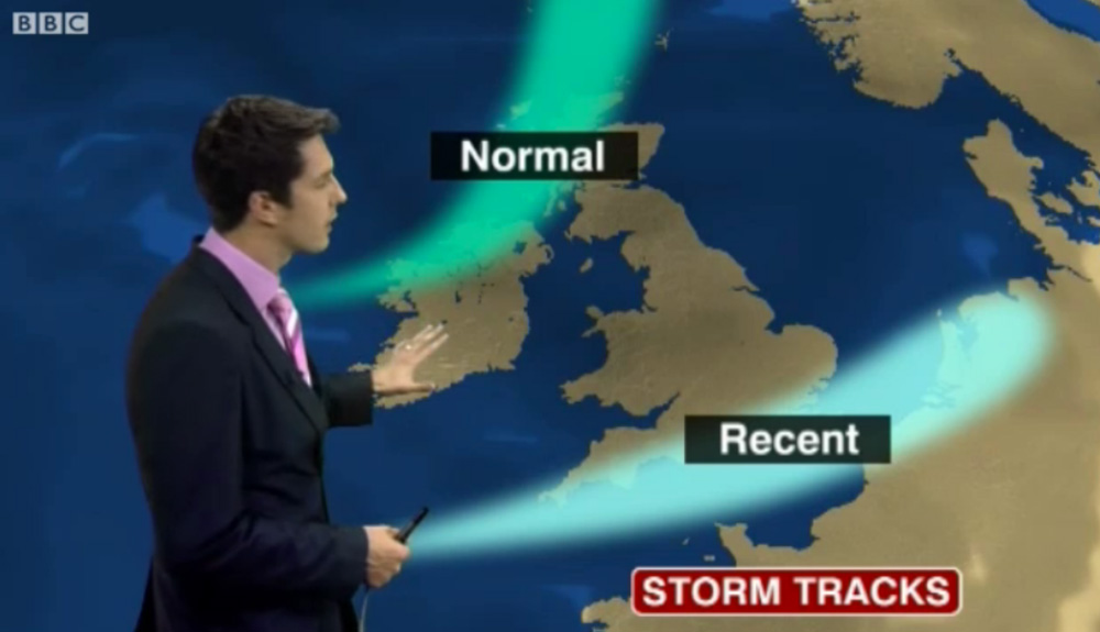
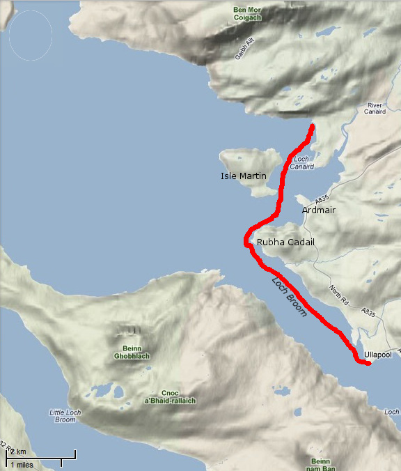
In 2011 I met Gael after he ran out of time and weather to complete the second stage of the Scottish Sea Kayak Trail he started in 2010 in his Grabner H2. According to the guy who wrote the guidebook, the SSKT is a 500-km run through the Inner Hebrides from the Isle of Gigha off the Kintyre peninsula to the Summer Isles, but with no shoreside infrastructure as such, most just follow their nose with the book’s help. In 2012 Gael returned to Skye for another go, now in the ex-demo Incept K40 be picked up from Sea Kayak Oban. In March that year Scotland experienced some very fine weather while England got the converse – a result of a misplaced jet stream (right). And so it was for Gael who managed a comparatively trouble-free run all the way to Ullapool where he rolled up his boat and bussed back to his car on Skye.
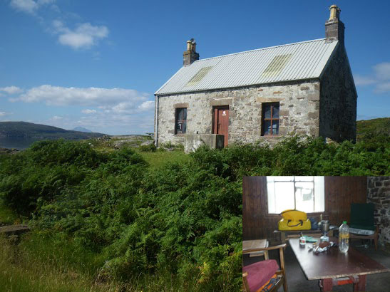
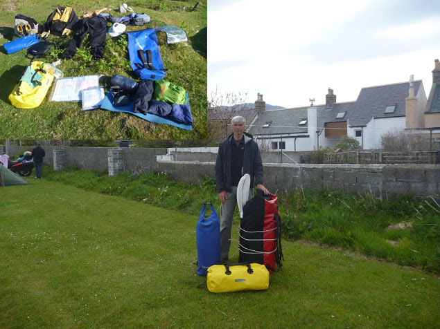
Day 1 – Kyleakin to Uags The trip began rather badly. I arrived around midnight in Kyleakin after an interminable drive from Paris with an exhausting final crossing through the Highlands mostly in the rain. I set up my tent quickly on the grass by the hostel’s backyard. Once in my sleeping bag, I fell asleep right away, lulled by the pounding of rain on the canvas and the rustle of leaves in the wind gusts. Early next morning I woke up with my feet feeling cold and wet; during my deep slumber I’d pushed them under the edge of the tent. Fortunately, my sleeping bag fill is synthetic and the nylon shell water repellent enough and with relief I found it was still dry inside. The ground all around was drenched and I could now test the effectiveness of my new Seal Skinz socks. It was still raining, so I donned my foul weather gear right away before proceeding with the usual pre-launch routine (inflate kayak, rig the accessories, sort food and equipment before closing the bags). Like last year I went to Kyle of Lochalsh Police Station to report my departure, then to the Co-op to stock up on McEwans in case I got shipwrecked.
Early in the afternoon, after a quick snack, I launched in Otter Pond by the Skye bridge. A fresh easterly was blowing out of the Loch against the flowing tide, raising the inevitable chop. I crossed the channel towards Kyle, then let myself be blown under the Skye bridge, leaving Eilean Ban to port. I paddled to Erbusaig Bay through the relatively sheltered Black Islands but decided not to proceed directly to Uags under the current crosswinds. Instead, I hugged the coast upwind towards An Dubh Aird from which the crossing would be much shorter. After vain attempts to take a picture of the two little otters which turned around me, I left the lee of An Dubh Aird and rushed towards the south coast of the Applecross peninsula. Two-thirds of the distance into the crossing I bore away and took a direct course to Uags, pushed at speed down the wind blowing along the axis of Loch Carron. Sadly I couldn’t surf the best waves though because the stern was too heavy with the beer. I landed around 6pm in Uags, and moved into the empty bothy.
Once installed, I hung my tent and sleeping bag to dry, then I rewarded myself this interesting first step with a hot tea and a thick slice of chocolate cake. Outside rain was still pounding.
Day 2 – Uags to Red Point I woke up at dawn feeling numb as my old foam sleeping pad had been of little comfort on the floorboards. The temperature was 5°C; so much for this jet stream. I went out to stretch my body and surprised a little doe grazing in the meadow below the ruined Uags hamlet. It scampered away before I could fetch my camera (this is a double entrendre called ‘lacking reflex’). But – it had stopped raining, the air was clear and visibility was excellent. The snow-capped peaks of the Cuillins stood out beautifully against the sky (below left) but the chill air from the northeast soon sent me back inside.
Once on the way from Uags an unexpected SE tailwind pushed me gently toward Sgeir Shalash but the breeze then turned NE, as expected. In the protected lee of the shore I paddled on north without difficulty, up to Camusteel, but when I reached the mouth of Applecross Bay, I had to fight against the wind. It funneled unhindered along the valley, whipping up the waters and raising an uncomfortable chop, until I reached some shelter in the lee of Rubha na Guailne. From there the long way north to Loch Torridon seemed a never-ending trudge. The wind had picked up to the point of pushing me hard offshore whenever I got 50 meters from the shore. I kept hugging the coast, despite the uncomfortable chop and the occasional breakers, because the wind was shifting SE, thus pushing me northward. When I eventually passed Rubha na Fearna I found myself facing the wind blowing right out of the Loch.
Loch Torridon greeted me with one of its customary gusts of which I’d had the humiliating experience the year before. I took shelter as soon as I could in a tiny cove hidden behind a natural breakwater. I badly needed a feed. After a snack and some rest, I pushed off to cross the Loch. I paddled a mile inland to gain an upwind margin of safety then I headed north. Wedged into the seat, with my legs holding tight on the thigh straps and squeezing the footrest, I blithely crossed the choppy zone, kept an eye on the most threatening peaking waves and checked off some landmarks in transit which I used to control my leeward drift with the other eye while admiring the spectacular scenery of the mountains towering over Loch Torridon (yes, all at once).
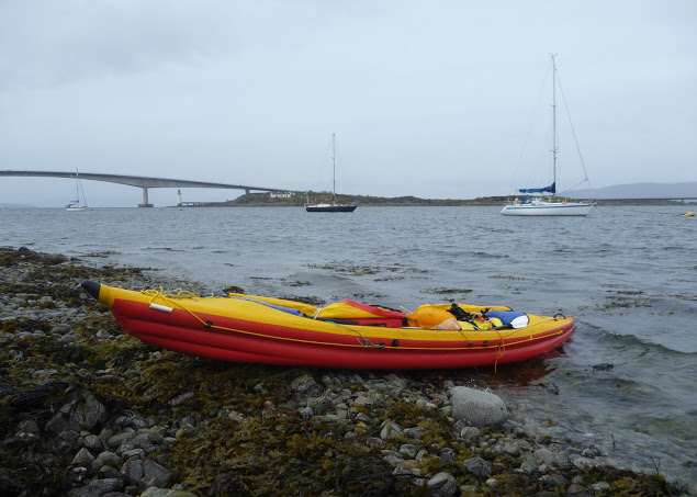
I returned to quiet water in the lee of the north shore, laid the paddle across the boat and started bailing. My open decked Incept kayak had ridden well on the waves but had shipped a fair share of water which was now swashing in the bilge. I pulled ashore in the early evening on a beautiful beach near Red Point.
The ebbing tide had just retreated beyond the tombolo that connects Eilean Tioram islet to the mainland, thus forming a placid lagoon. Some cows and sheep were grazing in the dunes undulating behind the beach. I pitched my tent in a hollow, barely sheltered from the chill NE breeze and crashed out.
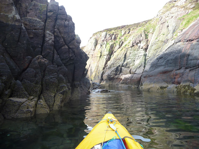
Day 3 – Red Point to Slaggan Bay The night had been cold but the clear morning sky made me hope for a warmer day. When I shoved off I didn’t know that I was about to enjoy one of the most beautiful days of my paddling life. Passing Red Point I noticed with satisfaction there was almost no swell. For once I wouldn’t be shaken by the rebounding waves and could explore the nooks and crannies of this craggy coast.
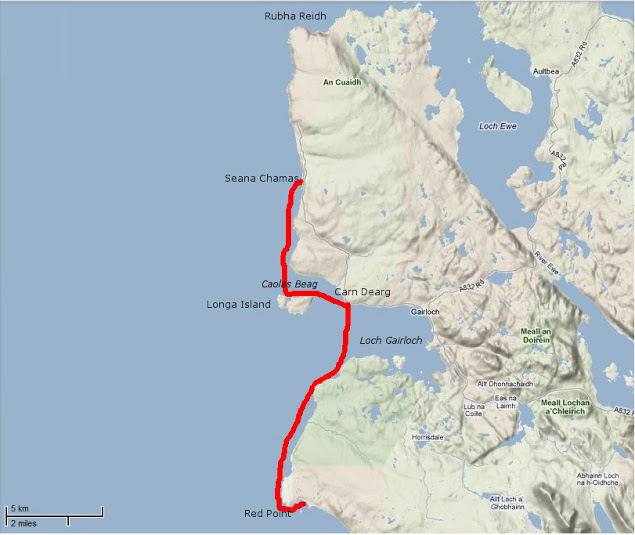
The sky became overcast and the NE wind picked up as I approached Loch Gairloch. The temperature dropped rapidly and I paddled more vigorously towards Carn Deag in an attempt to stay warm. I made a brief stop on the beach at Big Sand (left) but the chill breeze urged me on. I passed downwind along Longa Island with the hope of discovering a sheltered cove for lunch but found none. I then went on across Caol Beag, passed Rubha Ban and kept paddling north with my stomach gurgling. The beauty of the coast was worth the inconvenience of being cold, numb and hungry; huge sections of sandstone cliffs that had fallen in the sea provided an extraordinary maze of narrow passages that I enjoyed threading through. Erosion had also cut multiple geos and caves also worth exploring (I didn’t know what a geo was before reading the SSKT guidebook). I eventually reached Seana Chamas beach, largely uncovered by the outgoing tide and where I landed and dragged my kayak a few yards on a carpet of seaweed.
The sea was empty except for birds and a view that stretched westward to the Outer Hebrides. The Shiant Islands were clearly visible, standing out like a motionless line of battleships. I finished my lunch just as the tide returned up to my boat. The sky began clearing as I left and when I got past Melvaig all around me glistened under the sun.
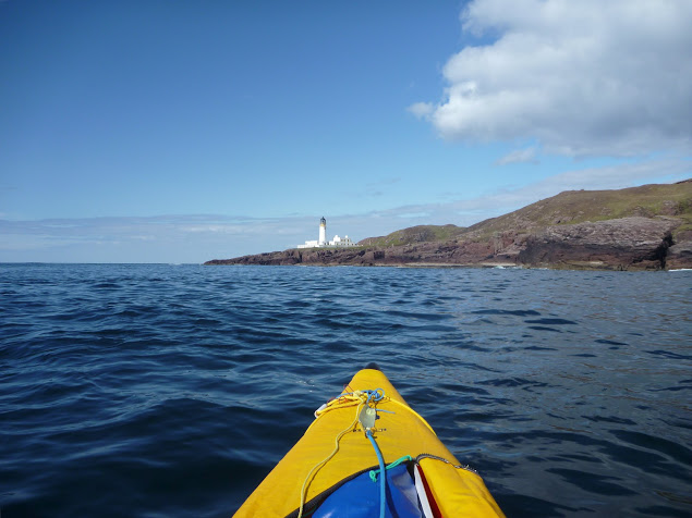
After half a mile of boulders the coast turned to sandstone crumbling cliffs again and I could resume prowling in and out of caves and geos under the bright light of this sunny afternoon. Quite suddenly behind another headland appeared – the dreaded Rubha Reidh and its striking white lighthouse. I felt the mid-tide current pick up as it dragged me over to the other side of the promontory. The whitecaps of a faster tide rip were visible out to sea but right under the lighthouse the sea was rippling gently against the reddish rocks. One of the most exposed stages on this route passed without event.
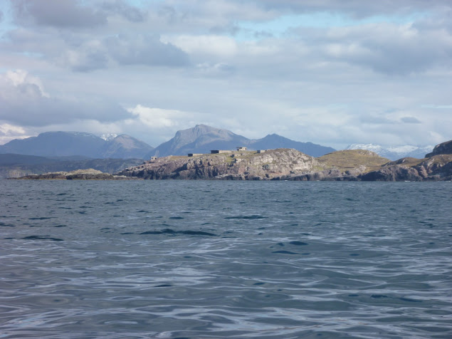
The NE wind that had been blowing since I left Kyleakin had dropped too, but there was still some swell from the north, preventing me from sneaking through the rocky labyrinth that stretched between Rubha Reidh and the beautiful beach of Camas Mor. Beyond Rubha Reid to the east the extraordinary snow-capped skyline of the Wester Ross mountain range rose from the horizon (left). Put in a trance by this sight, I carried on on an eastward course and arrived at Caolas an Fhuraidh. I took stock at the mouth of Loch Ewe before an exposed 4km crossing over to Slaggan Bay. To the SE lay Rubha nan Sasan still with it’s WWII bunkers and gun emplacements. At that time Loch Ewe had been the starting point for many Russia-bound convoys and a haven for Allied shipping. There’s still a NATO base there today. As I paddled to Ploc an t-Slagain I hoped I’d not be rammed by a nuclear submarine entering or leaving Loch Ewe; I’d read reports elsewhere in the Hebrides of these subs rising so fast the resulting wash tipped sea kayaks bow over stern. I reached Slaggan Bay at 7pm finding another perfect landing place, a crescent of fine sand surrounded by empty dunes.
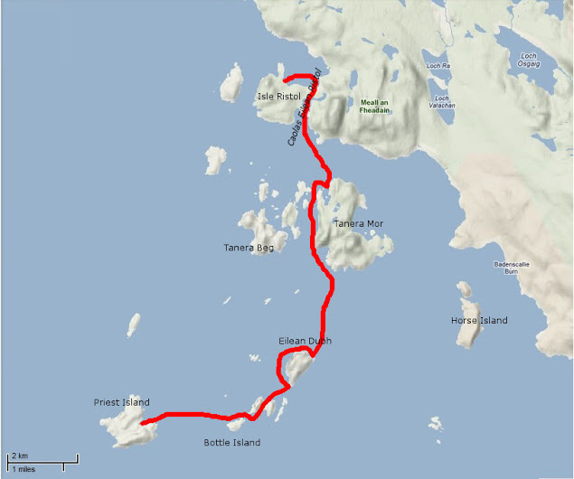
Day 4 – Slaggan Bay to Isle Ristol Under ideal paddling conditions I hugged the coast towards Greenstone Point, the last critical passage of the SSKT. The Point was flat and bare and proved even less dramatic than Rubha Reidh, although its rocky shoreline was wild and beautiful. From Greenstone I paddled on to Rubha Beag. In the distance the conspicuous peak of Ben Mor Coigach was towering over the horizon and to the NW lay a scattering of islets; the long-expected Summer Isles.
I headed towards the closest, Priest Island some 5km away. Halfway through the passage, the wind died off and the sea glassed over. The uncanny cries of the guillemots emphasized the eerie atmosphere; I felt like I was entering an unearthly space. From the SE tip of the Priest Island, I carried on around the west side. It was another paddling paradise with endless features to explore in the good company of seabirds and seals.
Once I completed this circumnavigation I paddled back to a cove called Acairseid Eilean a Chleirich (it’s quite a challenge to try to explain to other people the places I visited) where I pulled ashore onto a tiny uninviting boulder beach (left). As the afternoon progressed I uneventfully hopped through the convenient chain of islets lying between Priest Island and Tanera Mor, the biggest of the Summer Isles. I had intended to land near Althandu as I needed some of the facilities of the Port a Bhaigh campground, mostly their electrical hookups to charge the batteries, freshwater and even a shower, why not? There was also a pub close by.
But as I paddled through Old Dornie harbour I came within sight of the campground and within earshot too. The place looked packed and was definitely too noisy. After four days of solitude with no other sounds than the sea and the birds, I couldn’t stand it. So much for the camera, shower and a beer. I swung my boat south towards the lovely nearby beach of Traigh an t-Sean Bhaile on Ristol. I pitched my tent on thick grass which promised a comfortable night and the chilly cold kept any irksome midges from hatching.
Day 5 – Exploring the Summer Isles I devoted this day to exploring the archipelago as all these islands offer the type of craggy shore most sea paddlers are looking for. The sea conditions were again at their best for squeezing through narrow channels between rocks, under arches or into caves with almost no swell and light winds. I proceeded anti-clockwise around Ristol, paddling along its west coast then circumnavigated Eilean Glas Mullagrach and Glas Leach Mor.
Shags had built their nests in the crevices of the cliffs overlooking the sea. They were not easy to spot as their colour merged with the cliff but their unmistakable angry squawks betrayed their presence above me whenever I got too close. From Glas Leach Mor (the ‘large green stone’ a good description actually) I crossed to Tanera Beag. Here I gave a wide berth to a skerry occupied by a large group of singing seals that I didn’t want to disturb. The haunting sound suited the scenery perfectly.
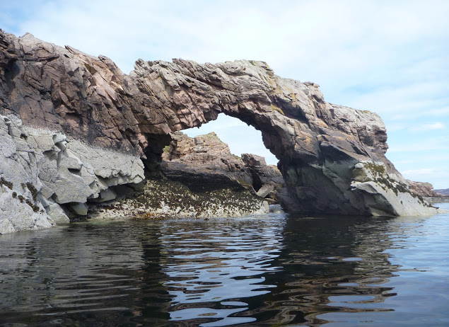
Tanera Beag is considered the most beautiful of the Summer Isles by the experts. Close to its SW corner is a cave deep enough for a tourist boat to get in and with a very high ceiling after which it’s called Cathedral Cave. Its SE corner is adorned with an elegant arch, which is another place of pilgrimage by all paddlers visiting the isles.
After completing the circumnavigation of Tanera Beag I pulled ashore for an overdue snack and a nap in a pretty little cove where the outgoing tide had left a broad sandy beach. Between Tanera Beag and Mor Eilean Fada I entered a kind of shallow lagoon of clear water. The tide was low and I saw my kayak’s shadow skip along the sandy bottom.
Later I landed in the Anchorage on Tanera Mor, a sheltered bay that opens to the east and filled with salmon pens. There is a floating dock for the tourist boat but the tea shop/post office where I’d intended to indulge in a brew and some piece of cake was closed. Tanera Mor (currently for sale) enjoys an offshore status which allows this tiny post office to issue its own stamps but no brew, no cake and no stamps for me today.
I hopped back in the boat and crossed the Anchorage diagonally and skirted Rubha Dubh, the east corner of the island. Here I entered a narrow cove choked with seaweed and backed with a pebble and boulder beach. High spring tides and gales had filled the depression beyond the beach thus forming a lovely pond, An Lochanach. I pulled ashore soon after two other kayakers. The guy didn’t look very happy to see me and curtly turned down my offer to help them to carry their heavily loaded sea kayaks. So I minded my own business, as I had just been advised to do. His wife came and offered remorsefully to give a hand, but I declined politely.
It had been a hot afternoon and I’d paddled without cag and without a cap for the first time in five days. But cold came back after 7pm and the Franco-Welsh relationships in the cove did not improve. Although our respective pitches were located 300 meters apart, each on one side of the beach, no invitation to share dinner was exchanged. It nice to be alone of course, but I like chatting with other paddlers too. Another time perhaps.
Day 6 – Tanera Mor to Ullapool On a beautiful sunny morning I headed SE towards Loch Broom and Ullapool. Sunny but cold, chilly indeed, so chilly that I had my breakfast in my sleeping bag.
In the meantime, the wind had shifted SE so I slogged against it all the way to Horse Island. I paddled through the tidal gap which divides this island from its northern tip, Meall nan Gabhar. Once through I pulled ashore and found a very convenient pitching spot. I regretted not having carried on to this place yesterday, instead of staying next to unsympathetic paddlers. So seemed to say the half-dozen seals romping about behind me. The sky was promising some fair weather that had been a long time coming. As the breeze didn’t abate I took shelter in the lee of Acheninver. But as soon as I got past Rubha Dubh Ard I fought the headwind again until I reached the base of Ben Mor Coigach.
Then I paddled below the sheer slope of the mountain until I got to what looked like the white sands of Camas Mor beach. Actually, it’s a pebble beach facing Isle Martin and the guidebook said amethysts can be found here, but I didn’t find any. By 2 o’clock clouds covered the sky and some chill air forced me back into my cold-weather gear.
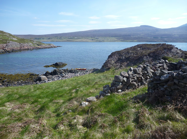
I shoved off shortly after lunch and enjoyed passing the last natural monuments of the Trail. I rounded Rubha Cadail, addressed the last salute to Ben Mor Coigach and entered Loch Broom. The wind unexpectedly veered NW and pushed me gently towards Ullapool.
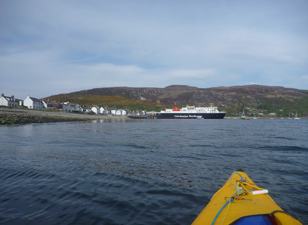
Once ashore I pitched my tent under the stares of some motorcyclists wondering where the hell I’d come from. A leather-clad fellow told me the owner was already gone and would return early next morning to collect the fee. Meanwhile, I washed the Incept to remove the grit scattered in the bilge, wiped it dry, deflated it, rolled it, and pushed it into my huge 160-l Ortlieb Kanurucksack. The K40 doesn’t fold as compactly as my good old hypalon H2 but I was relieved it crammed into the bag. I enjoyed dinner at the water’s edge overlooking at the now placid waters of Loch Broom, glowing in the satisfaction of my achievement. It has taken three years and two different boats, but I’d completed the SSKT in an inflatable sea kayak along with one of Europe’s most striking shorelines. Celebrations continued at the Ferry Boat Inn where I e-mailed friends and family, sipping some good beer, the sound of music replacing the soothing sound of the sea lapping the shore.
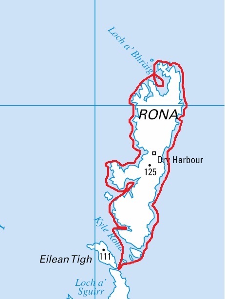
Ullapool to Kyleakin The weather was set to improve in the following days and I wondered whether to paddle north and round the Point of Stoer, take the ferry to Stornoway for a glimpse of the Outer Hebrides, or complete the exploration of Raasay and Rona that I’d started the year before. The first two options required maps that I was not sure to find in Ullapool. and I was also missing sailing directions.
So I packed all my gear in my three-bag travelling arrangement: boat and paddling gear in the 160l Kanurucksack, camping gear and clothes in the 59l XPlorer bag, food, cooking gear, books, maps, tools and all the rest in the 49l Rackpack. The result was portable but heavy and I had a half mile walk to the bus station by the ferry terminal. Luckily the owner came by for the fee and gave me a lift. Soon we were en route to Inverness by bus; an alternative would have been leaving the bus at Garve railway station, halfway to Inverness and hopping on a train to Kyle of Lochalsh.
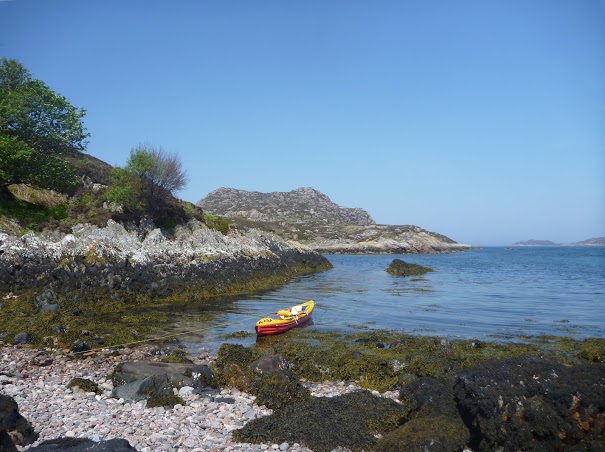
Eventually, I decided to park up in Kyleakin on Skye and undertook a very enjoyable three-day tour around Raasay and Rona. The year before I’d experienced the charms of these islands despite the unsettled weather – this time conditions were ideal. Back at the pier three days later, I was giving the Incept a wash on the slipway when a Land Rover towing a trailer full of sea kayaks turned in. A party of men got out of the truck, unloaded the kayaks and started putting paddling gear on. As they carried the boat to water they came over to say hello and asked about my boat and my trip. They were attending a kayak class beginning this very day. Their first-day program was a shakedown paddle in sheltered waters before a guided multi-day run to Sandaig. The guide joined the conversation and yet again I endured the usual hardsheller’s drivel about IKs. Ten minutes later I watched the student awkwardly clambering in their kayaks; for some of the clumsier it took quite a while. I told them they were lucky modern kayaks had such larger cockpit coamings – but not as big as mine! By the time I got to my car the temperature inside was like an oven, despite the screen I’d fixed over the windshield. My chocolate bars had melted. In northwest Scotland? Whatever next.
Last summer I spent 3 weeks in Sardinia with my wife. We were camped near Santa Maria Navarrese, a quiet seaside resort and a strategic location from which to explore the splendid and relatively untouched Ogliastra region, located on the central eastern coast of the island. There the mountains rise to over 1000m within 20 km of the shore, hence our plan to combine a beach holiday with hiking and paddling activities. Real sportsmen would add climbing and mountain biking as Peter Harold and his Lemon House guests do. Me, I’d rather add enjoying Sardinian food and wine to the program instead.
I brought my revived Grabner H2 IK. It took us along the astounding coastline to tiny coves that can be reached only by sea. Such fabulous places are found from 20 minutes to 2 hours of relaxed paddling, stopping en route to have a refreshing swim in turquoise water or to stretch one’s legs on a short walk inland into the fragrant Mediterranean macchia.
From Santa Maria Navarrese (aka: SMN) the coast up to north is mostly rugged rock wall all the way to Cala Luna, punctuated by caves, coves and superb white sand beaches tucked under towering cliffs. No easy escape routes leave from those beaches; it would take a few hours staggering along deep codulas (gorges) and up steep and craggy paths before reaching the plateau over the coastal ridge. Although rugged and remote, it’s not real wilderness in summer, because this stretch of coast is travelled all day long by dozens of tour boats and hundreds of rental “gommoni” (Zodiac-style, hard-bottom RIBs) sailing from Arbatax, SMN or Cala Gonone (the next resort north of SMN). Should a boater get stranded he could easily hitch a lift back to port. Two beaches; Cala Sisine and Cala Luna have tourist facilities in summer such as bar, restaurant, toilets, with employees staying overnight. Sometimes whole families, stay overnight as well. In Cala Luna the restaurant is well known to help ‘naufraghi‘ (castaways); ill-prepared or unintentional overnighters. Sea traffic starts fading from 5pm with the beaches getting covered in shade, and disappears from 6pm to 8am, as often does the sea breeze too, so late afternoon and early morning are definitely the best paddling times. A paddler or hiker traveling this area offseason would be on his own.
So one morning I left for a 2-day trip to Cala Luna and back along the Ogliastra coast. I launched my loaded Grabner in the shore break beating on the Tancau beach. I jumped awkwardly on board, intending to shove off quickly and not to be dumped back. Unfortunately, my inelegant butt crash-landed right on the backrest. It collapsed under my weight with a sorry crack. I paddled on to the nearby Santa-Maria Navarrese marina, barely controlling my course in the 2-foot chop raised by the F3 Grecale (NE wind), then pulled ashore on the slipway for repair.
I found no immediate solution to fix the broken backrest bar. The middle backrest was intact but it was too long to fit in the stern backrest position. However, it could be fitted between the new brackets recently added by Grabner. These circumstances forced me to test the solo paddling position which requires only one backrest. I shifted the middle backrest and removed the remnants of the stern one. Then there was the footrest problem to solve. The footrest is a 2-part aluminum bar. One part is mostly a tube while the other is a plain bar of a smaller diameter which can slide into the tube, so the total length adjusts automatically to the width of the boat for different positions of the footrest. The bent ends of the footrest are tucked into fittings glued on each side of the cockpit. Because of the bent ends the footrest must be taken apart to connect the rudder pedals on it. The crude aluminum material gets corroded quickly in seawater. To prevent it seizing up, I used to spray WD-40 in the tube. Many years ago I once forgot to take apart the footrest and after a few days, it got seized up for good. And now it was too long to fit in the forward tapered half of the kayak. It would be a no-rudder/loose-footrest trip then.
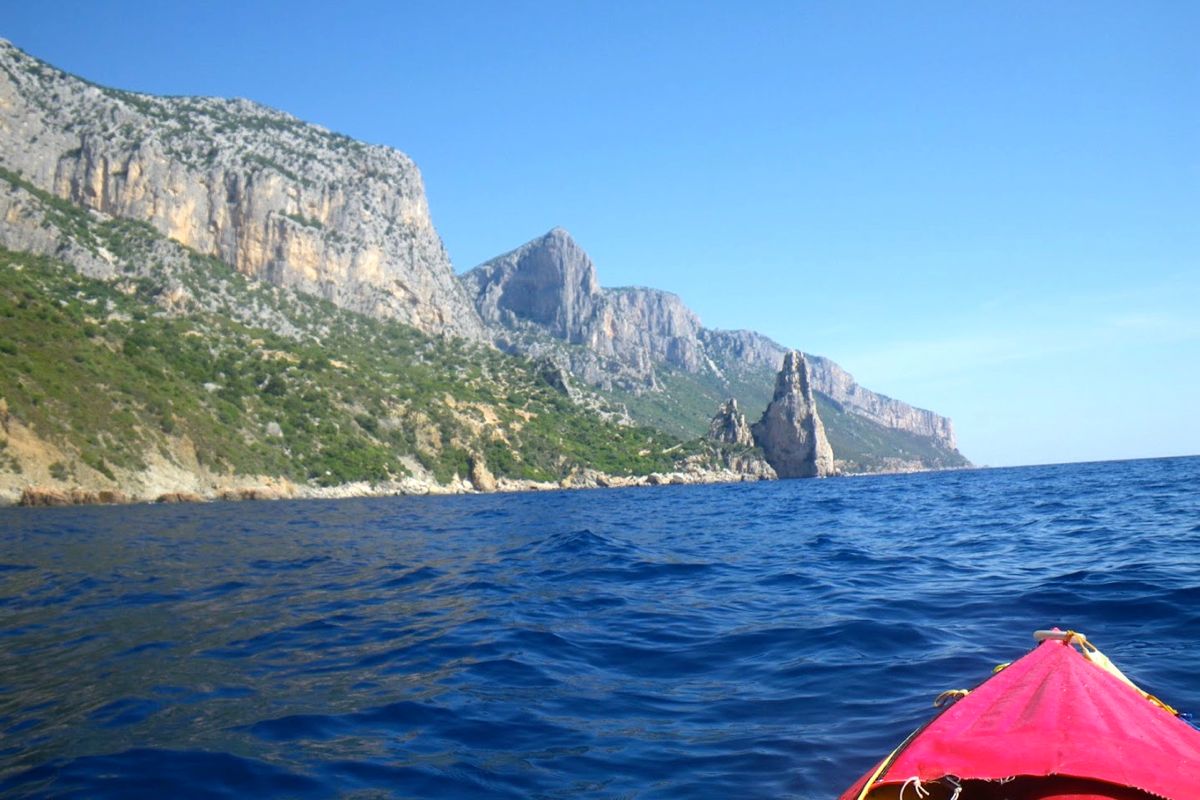
The Grecale abated as I left SMN and headed to Pedra Longa, a conspicuous rock steeple 128m high which stands out of the shoreline. From Pedra Longa I carried on along the boulder beach of Cala Forrola, under the precipitous cliff face of Punta Giradili. In good sea conditions when there is no shore break it’s possible to land safely onto those round smooth boulders. There’s a nice resting spot nearby, with a spring and a large flat slab to lay on for a nap under an overhanging rose-bay tree providing shade from the scorching sun.
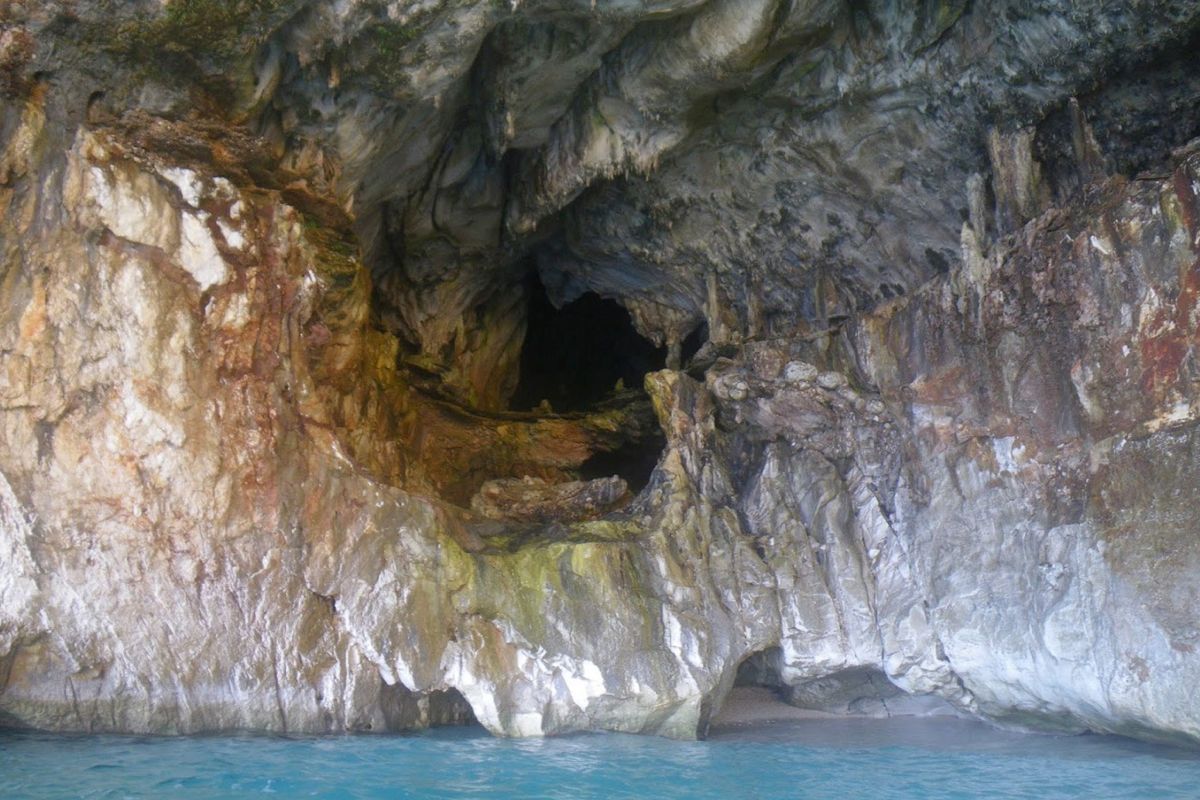
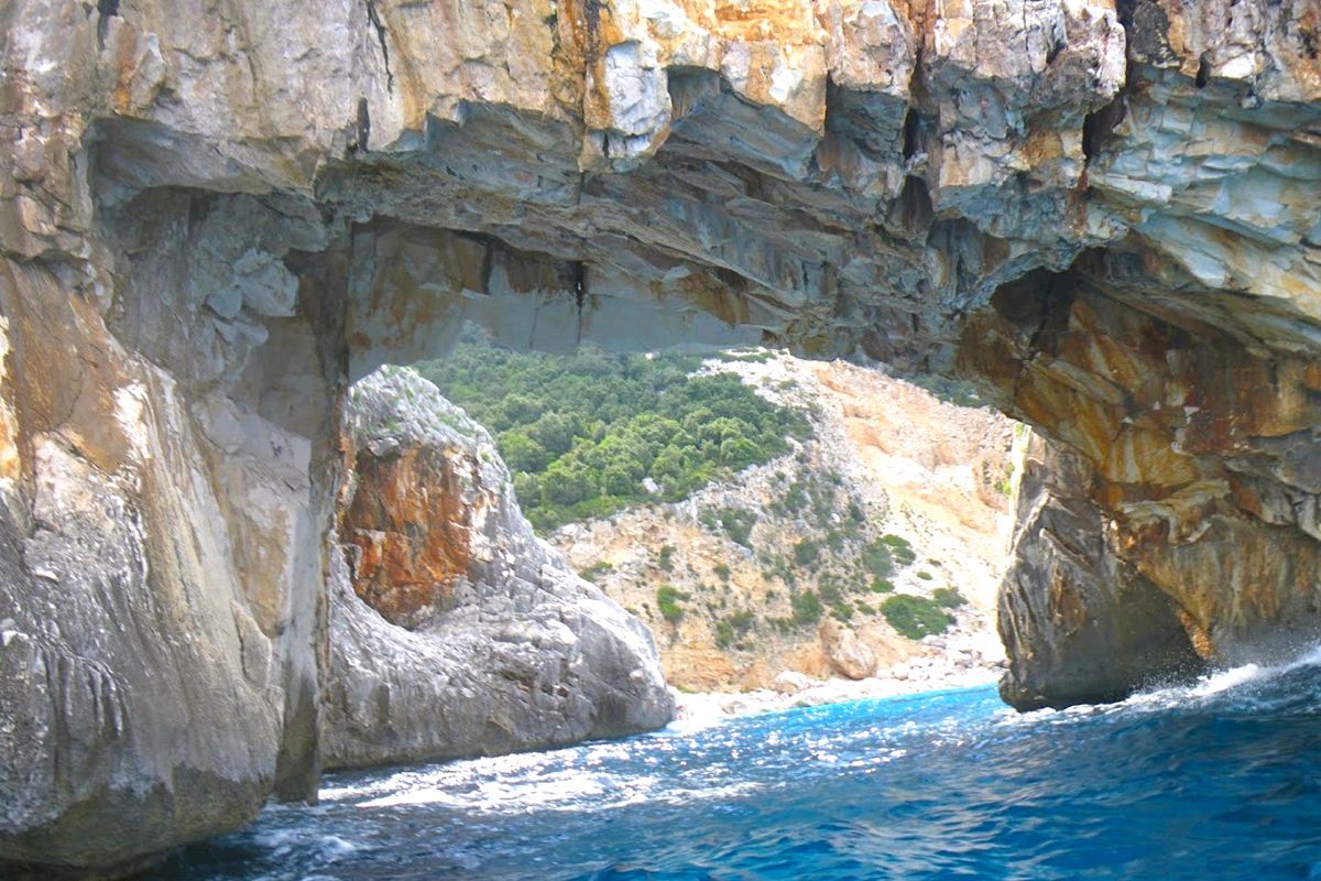
Passed Punta del Pecoraro the coast becomes a vertical wall with nowhere to pull ashore for a significant distance. The only dents in the cliff were the Grotta dei Colombi (cave of the doves) and a sea cave close to the Capo Monte Santu. An opening in the cliff vertical face loomed right under this impressive headland, the entrance of Porto Pedrosu (Grouse Cove). Porto Pedrosu is a fairly narrow inlet, narrowing even further as it goes deeper inland. It ends on a boulder choked beach, 3 metres wide. The gommoni are too large to get there; they stay on anchor near the entrance of this mini fjord and the crews swim ashore. I filled my net anchor with large pebbles, tied it to my bungee leash and put it on the edge of the foredeck. I pushed my boat out to sea with the painter in my hand. I give it a yank when the kayak was at the right distance from shore and the anchor fell. I pulled the boat back a bit and tied the painter around a rock. The bungee holds the mooring lines tight provided the anchor is heavy enough for not tripping on the bottom. I had the place all to myself for a quick lunch and a short siesta.After leaving Porto Pedrosu I visited Porto Quau (Quail Cove), the next inlet, also like a gash in the cliff, without any landing spot as it is walled in on all sides by plumb faces or piles of tumbled large boulders.
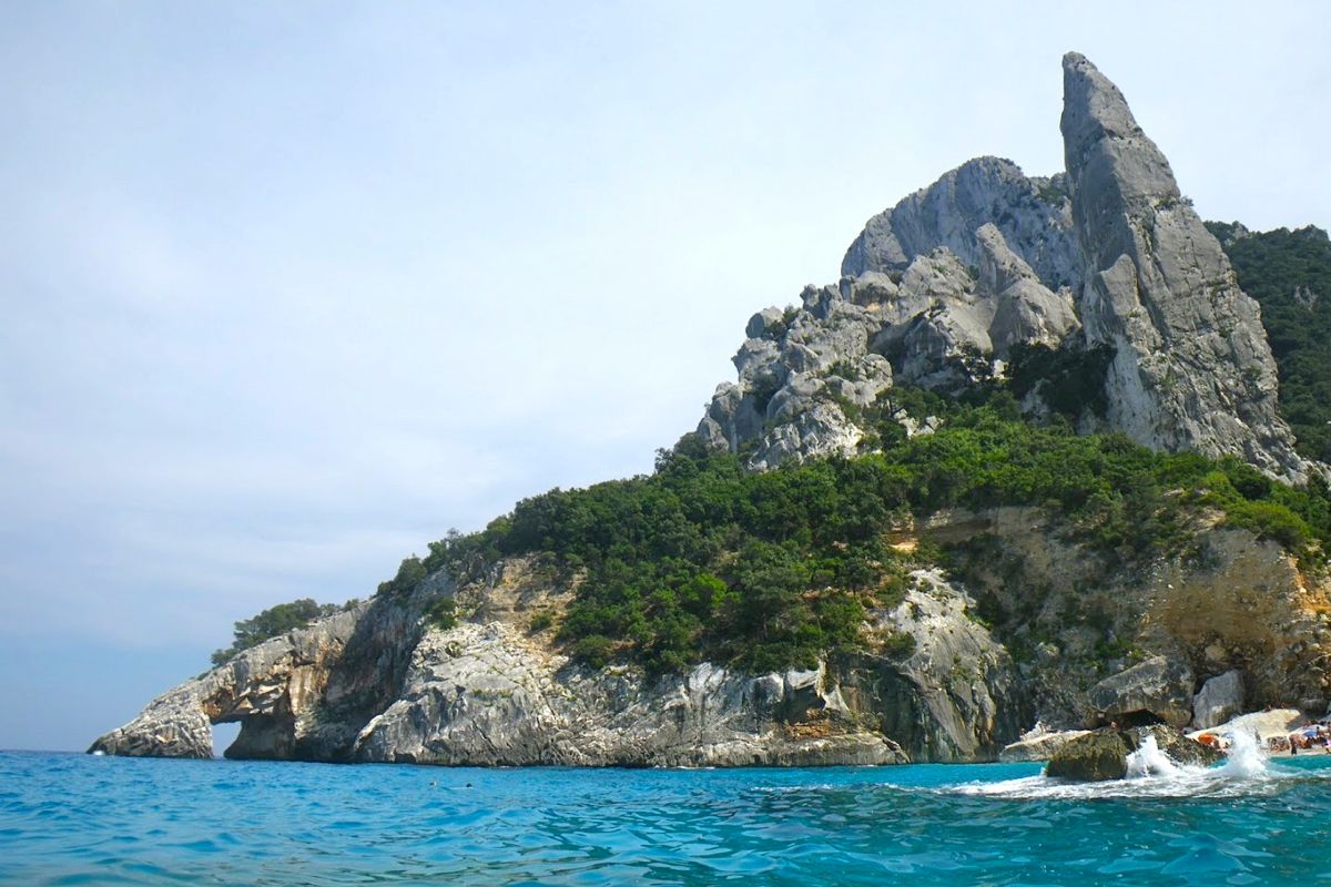
I carried on around the sheer 250-m high Punta Iltiera keeping some distance from the shore to stay away from the uncomfortable rebounding chop. About 3 kilometers later the arch of Cala Goloritze came in sight. I went through the arch, which I had not expected as it usually swarms with swimmers. The otherwise lovely beach was still crowded with sun worshippers. Unlike other beaches further north, this place can be accessed after a relatively short (1h35) and easy (530m descent) walk from the Golgo plateau above. Italian families get there carrying large umbrellas, beach chairs, beach toys, ice chests and picnic supplies to spend the day swimming, tanning, playing, eating and making an incredible din. The return trudge up the slope with the panting and grunting hoards is quite an experience, like being part of a commedia all’italiana movie. Besides the arch, Goloritzé is also famed for its 127-metre long needle rock, the Aguglia, ‘a sought-after destination for free-climbers’ say the guidebooks. From the sea it looks smaller because all the place is dwarfed by the towering mass of 466-m Punta Salinas.
The next renowned and highly advertised place is Cala Mariolu, a postcard-like white sand crystal water beach. It’s not exactly sand but tiny rounded gravel. By 6pm most boats were gone. I had noticed earlier that this time was the rush hour for tourist boats and rental boats as well. I had seen them almost everyday return at full speed to SMN or Arbatax to get there by the 6pm cut-off. I passed Cala Biriola while the last batch of people was being evacuated. Groups of visitors are landed on different beaches and for a limited time in order to avoid too many people cramming the same beach at the same time. I was alone on the sea and Capo Monte Santu looked far behind by then. I reached Cala Luna by 7pm. It wasn’t dark but the sun had disappeared behind the mountains. I pulled ashore in front of the large caves located on the north end of the beach.
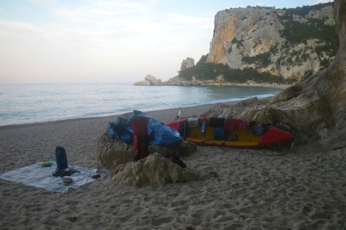
The beach edge was very steep with the typical dumping wave breaking right on it. I looked for the smoothest landing place and stood by for a while before paddling in, timing waves sets. I caught the back of a wave but it did not carry me high enough to reach the flatter ground and I landed on the steep slope. The next wave crashed in, half filling the cockpit, as I jumped out of the boat and grabbed the bow handle – easily done with an open IK. I hauled the boat turned bathtub up the slope and carried the gear near the entrance of a cave. Setting camp was quite simple: laying an old space blanket as a groundsheet on the sand. In the very unlikely case of rain coming, I could go inside one of the caves or retreat into the codula and rig my tarp between shrubs. Dinner was instant polenta, pecorino cheese, fruit, all washed down with some Ichnusa beer. The issue with polenta – a bit like couscous – is that it has no taste. Simply adding a generous spoonful of butter, bits of cheese and some spices make it delicious (there might be more sophisticated ways to enhance polenta though). I was a bit tired and I fell asleep shortly after dark under an extraordinary starry sky, sliced now and then by the seasonal shooting stars. Next morning I woke up at dawn and watched the sunrise on the placid waters. The temperature was relatively cool and I stayed in my sleeping bag until 6.30. The obvious upside of outdoors living in warm and dry weather is how little equipment you need. My heaviest pieces of gear were my 10-liter water bag, and a pack of beer. In no time after breakfast I packed up and brought gear and boat to water. Again I launched my kayak at the wrong time. I thought there was a lull between two bigger wave sets, but I was hit by one before I could jump on board and push-off, right in the dumping zone, at the bottom of the beach steep slope. The boat got instantaneously swamped and severely tossed back toward the beach, pinned down by the waves in the impact zone. Most pieces of gear floated in or around, each held close by its respective tether. The H2 was now a heavy piece of jetsam that I struggled to haul on higher ground.
I bailed the water, secured the gear under tighter bungees and shortened tethers and timed the wave sets more accurately. I put to water again, at the right moment this time. ‘Nothing was lost, only a bit of pride’ as said Audrey Sutherland in Paddling North. By 8am I was still alone on the water, save for one or two gommoni heading south. I passed Cala Sisine and Cala Biriola, still empty of visitors. The sea was much calmer than the day before, and I could hug the coast and visit many caves and crags along my way southward. At 10.30 the boat traffic was picking up and I stopped at Cala Mudarolu with a deep cave at the end of this lovely cove. The entrance is barred by a gravel beach. There is water inside, brought by the gales when the sea reaches over the tombolo. Unfortunately, the surface of the pond inside the cave is littered with plastic bottles, soda cans and all sorts of trash. It was 11 and the boat traffic was now in full swing. Fortunately, most boaters hop from one beach to the next, overlooking the rocky shore in between. I passed the beach area of Cala Mariolu where a large fleet of motorboats was moored beyond the line of buoys marking the 300 meters limit from the shore. At noon the traffic stopped: pranzo time is sacred in this heavenly country. over the next 2 hours all I could hear were the gulls and the water lapping the cliffs, instead of roaring gomo engines. I gave up stopping at Cala Goloritze, scared off by the crowd on the beach and in the water. Instead, I paddled on to Porto Pedrosu for a quiet lunch stop in the shadow of some Holm oak. Now it was time to fight the regular SE afternoon breeze around Capo Monte Santu, but the lumpy chop of the day before had turned to a gentle ripple. From half a mile offshore I stared at the stupendous ruggedness of the Supramonte, while paddling my way back to SMN. No polenta tonight, but a hearty 7-course seafood dinner at the Pescheria, a nice restaurant on the shore of the Tortoli lagoon where they even offer to carry you home.
The other day a friend relatively new to yaking invited me and a mate to paddle a river near her home. The Colne runs between the edge of Greater London and the M25 motorway just a stone’s throw from Heathrow airport.
Looking at a map (far below) and more so at a sat image, it’s hard to distinguish the actual course of the Colne among the many waterways, reservoirs, overgrowths and the Grand Union canal which all fill this part of west London’s perimeter, but Lois had already recce’d a route which included half a dozen fun weirs and other challenges along the way – all up a run of around six miles. Chief among these tests was what must surely be an urban paddler’s nightmare; a weir drop inside a low tunnel that passed under a kebab shop and which we dubbed TheKebab Death Tunnel Weir (the word order is interchangeable). The thought of being spun in a dank, sunless hydraulic or jammed against a rusting grate as clammy kebab fat dripped onto your forehead from cracks in the overhead brickwork was surely the makings of a deleted scene from David Lynch’s Eraserhead.
All that was far from our thoughts as we bundled over a bridge parapet and inflated Lois’ Sunny IK which Robin was borrowing. Lois was using her newish hardshell Dagger and I was in my Yak packraft. Lois quite rightly rationalised her controversial IK betrayal by explaining that as she lived on a canal she just wanted a boat to hop into anytime (her Gumos having sprung slow leaks). I can relate to that though I wouldn’t go as far as actually buying a plastic coffin. We swooshed off under the bridge and downstream on a lovely autumn’s day, along what transpired to actually be a proper river with a kosher current, far from my expectations of a concrete lined culvert awash with urban detritus and pestilent scum. We passed under a huge arc of brickwork supporting the westbound mainline railway and soon sidled up alongside the Grand Union canal. Not that we could see it. Even the OS map gets quite confusing, marking rivers or other waterways passing across lakes and wetland reserves. But once on the river the way ahead was usually obvious.
At one point what looked like thick mat of giant watercress carpeted the river bank to bank (actually pennywort, a very troublesome weed I am informed). Up ahead Lois’ Dagger ploughed into the vegetation (left) which amazingly proved to be paddleable, although with my wide, flat-hulled ‘packa I found reaching out and tugging on the floating wortrug worked best.
Soon we came to our first weir, a drop of a foot or so but where we did the right thing and hopped out to check we weren’t tipping over onto some gnarly boat spike. All clear so Lois slid over effortlessly into some shallows, then Robin beached himself inelegantly on the rim in the possibly under-inflated Solar. Knowing this, I sped the Yak up to warp speed and scrapped over with a splash.
More riverine bliss ensued with barely a crisp packet to sully our glide. Delicate foot bridges led to cosy cottages. Another double weir looked deadly from above but recce’d from below was no drama. No having yet recognised the benefits of spray skirts, Lois’ Dagger was taking a cockpitful on some of these weir drops. The Solar too scooped up some swill, but this was the first occasion where I zipped on the Alpacka’s spray skirt – mostly to keep my legs warm but also proving it did what it was supposed to.
Up ahead, another clot of creswort choked the channel, but this had got thick enough to catch some crap so we hauled out stinky twigs and other rancid mush before hacking our way in. The rigid hardshell was best; my Alpacka (above) while broad was at least light, while the Gumboat put up a fight and Robin split his paddle all the better to dig his way through (right). Another weir with a drop of a couple of feet gave Lois a fresh rinse as we neared the outer London suburb of Uxbridge.
Bankside trees gave way to razor-topped railings protecting the back end of industrial units and things turned decidedly less serene as we neared the gaping twin maws of the Death Tunnel. It burrowed under a parade of shops, the pride of which was unquestionably the broad, handsome frontage of the Burger Kebab Galaxy restaurant.
Two limbo-low bridges lead to an even lower rusty sewer pipe spanning the canal, and up ahead two arches reached into the watery gloom like a farmer’s rubber glove and where the rank stench of congealed doner fat choked the air. A chink of light marked the far end of the 70-foot tunnel (left) where the roof – strung with electrical piping, rotting rafters and mummified bats – pressed down to just a couple of feet right over the edge of the drop. Lois said last time the water was higher and they couldn’t even see the end, but they’d edged in anyway, slid over and survived.
Even then, you never know when a burned-out scooter or half a tree might be poised to spoil your weir and anyway, Lois was sure this weir was higher than anything we’d done so far. So Robin and I clambered up onto the footbridge (left), walked round the far side and waded up into the tunnel as far as we could against the current. With the help of my camera’s flash I was able to get far enough in to see that the three-foot weir was actually a narrow 45° slide of about 3 feet, not a straight drop. Much less risky.
Now reassured that I wouldn’t be pitched out of the packraft to smack, face-first into to a span of festering, greasy brickwork, back at the boat I squeezed myself under the sewer pipe (right) and let the speeding current draw me in, making sure to keep well away from a broad side tunnel which led off to the right and didn’t look like it had a happy ending. I didn’t want to end up being squeezed out of someone’s kitchen tap like rubber-boned Janus Stark. In the main tunnel, the roof bore down and I stowed the paddle as I tipped down the chute, getting shoved against the right wall as I ran out towards the light like a near-death experience.
Lois came down next (faintly visible above left) and also got pushed right at the base of the chute and semi capsized.
Kebab Death Horror!
Her paddle floated down towards me but before I could grab it the eddy caught it and floated it back up towards the chute. Meanwhile, soggy arsed Lois hopped out and dragged her waterlogged Dagger into the piercing daylight. Robin came down next (left), got pushed over but kept it together. It seems the tunnel weir had set up a long, thin anti-clockwise circulant or eddy which came upstream and looped back down just below the chute and explained why we’d all got pushed into the right wall as we came off the slide.
But we’d survived the KWDT and soon cruised past a striking municipal bronze statue depicting a trio of naked nymphs grappling over a giant Christmas pudding (left), a scene plucked from the otherwise unexceptional Lost Chronicles of Uxenbride discovered not far from Kebab Galaxy in 1892. And here at last! A plucky South Bucks District Council dustbin uprooted from it’s roadside vigil and flung into the Colne by some beer-crazed revellers high on nitrous oxide. Now that’s what you call urban packboating! There was more to come. What is a paddle in merry England without getting a bollocking from a vexed bankside angler. We’d seen a few upstream who’d mostly ignored us (I don’t waste greetings on anglers anymore), but as Robin and I rounded a bend following another weirlette, some grumpy git wearing rubber up to his neck let us know his feelings, concluding with: ‘You coming back?’ (demonstrating his lack of understanding about how kayaks and rivers interact). ‘No sirree‘ ‘Good!’
His mate just down the way was more civil and explained ‘there’s no navigation on this beat, it’s in the agreement…’ pointing to a sign, rather ineffectively positioned downstream that merely said Private Fishing or some such. I didn’t know the paddling status of the Colne and maybe Lois didn’t either, but a quick Google later on showed up threads on the SotP and ukrivers that indeed suggested the Colne hereabouts had been leased by a bankside golf club to Uxbridge Anglers Club, and their £80 membership fee helped entitle them to exclude paddlers on parts of the Colne. What about the Magna Carta and all that? Which parts are off-limits is hard to determine unless there is a blanket paddling ban.
We certainly saw no ‘ No Canoeing’ signs so it all left a sour taste for a while, but that’s the way paddling is in England thanks to Edward the 1st’s short-sighted bequest to his loyal noblemen (or so the story goes).
The last mile or two down to Packet Boat Lane passed without rancour as the late autumn sun seeped through the falling leaves. The current was speeding along by now and negotiating a squeeze around a fallen tree and some brambles, Robin managed to low side the unskeged Gumotex at exactly the point where Lois had tipped in on a previous occasion. Luckily he was also in shorts and hopped back in the Solar. Somewhere here there was a blockage of fallen trees and flotsam which we couldn’t paddle through and so made our only short portage. ‘Take out, rrrrrrriver left!’ yelled Lois, scarring the crows into the flight path of several 747s lowering their landing gear. Incredibly, Packet Boat Lane (near Iver) is actually a drivable ford across the Colne, rated at no less than five stars by the peer-reviewed wetroads.co.uk.
Once back at Lois’ cosy houseboat Robin couldn’t resist nipping back and having a crack at the car-swallowing ford on his well-travelled trail bike. I stood in the middle with water halfway up my thighs and filmed the action, thinking, ‘rather you than me, mate – it’s a long push back to Crawley’. Sure enough, before he got even halfway his Yamaha spluttered to a stop and we pushed it back like a couple of spotty teenagers trying out their first stolen bike. Back on the barge the throbbing woodburner and a hot bowl of soup soon thawed our chilled limbs as we tried to analyse what the heck was wrong with Robin’s moto, other than acknowledging an engine can’t run on water like a kayak can. We left Robin to it, I rolled up my Alpacka and rode back home across London. Thanks to Lois P for organising a great day out.
Don’t get excited, we’re talking a few hundred metres of Class 1.1, but that’s as good as it gets around here. We’ve had a lot of rain in the last week, enough to make the only paddleable river – the short Osgaig – worth a poke with a paddle. I was here with the Yak last year at slightly lower levels, so this time was expecting a smoother run in the Solar (now with an improved seat-foot set up), followed immediately by a comparison run in the Alpacka Yak.
Gumotex Solar IK The good thing with the Solar is it’s old, worth next to nothing but tough, so can be dragged like a hardshell with the Yak in the back. I considered jury rigging some thigh straps; it could be done now through the new footrest pipe and around the seat mounts, but looking at the river as I drove up, it wasn’t really worth it. Thigh straps are what makes any deckless boat – air-filled or hard-shelled – much more controllable when things get choppy. Even WW packrafters insist straps are the way to go.
With the skeg off, it’s easy to seal launch off a grassy bank and into the scrum just below the waterfall which looks a bit complicated so was no less inviting this year. As I spilled over the first little step I tried surfing like people do. But the Solar wasn’t especially dynamic or there wasn’t a strong enough recirculation going on to make it feel interesting. So I swung round and set off. Even at full flow, the Osgaig is a shallow, bony river better suited to an injection-molded TNP ‘spaddle’, not 220 quid’s worth of carbon-light Werner Corry which was picking up new scrapes as I jabbed at the water to keep the boat on line. It was really quite effortful with the Solar, at 3m or nearly 10 feet it’s perhaps a bit long for this sort of thing. I hit the one or two rapids full face, kicking up a satisfying splash and remembering that ‘bring it on’ exhilaration when trying an IK and white watering for the very first time on the Salmon River in Idaho all those years ago.
The river branched near the Loch; left looked all froth but too shallow so I swung right but again scrapped and shoved from one bar to the next. I was hoping to make it all the way to Loch Osgaig but up ahead I saw the tree strainer I recalled from last year so, stuck on another rock and by now steaming out of the ears in my heavy drysuit, I stepped out and walked back upriver.
Alpacka Yak Packraft A few minutes later I hopped into the snug Yak, spun round and slipped over the first drop. Spinning back, I tried to surf as I’d just done in the Sunny but it wasn’t happening. I guess the Yak is just too wide, light and too much drag to fight the flow. Off I went downstream, trying to avoid getting snagged while lining up to take the peak of what waves there were. Jammed in the yellow tub, sat lower and with higher sides, it felt much more responsive than the longer Solar and so was less effort to ride. Perhaps part of it was that a good line is less vital; most of the rapids I could have taken backwards and that added up to more fun. So there it is: a tight-fitting packraft is more fun on easy white water than a 3-metre IK. When I got snagged towards the end, I just stepped out, threw the boat ashore, and staggered out over the slimy boulders.
Le Grand Gonflateur himself, Gael A sent me this image to illustrate something. Its composition and colouring was so magical I’m compelled to elevate it to the IK&P Picture of the Week. Captured in 2005, the location is the River Epte, a tributary of the Seine in Normandy and site of Monet’s no less idyllic 1899 painting, ‘Waterlilly Pond’ (left). It looks like Gael is sliding down a burst canal bank on his H2, while his trusty compadre observers from the reassuringly stable platform of a Mk1 Sunny gumboat. Behind him a sign warns ‘Access Interdite – Danger [sauf gonflards] and nearby a docile cow nuzzles the trunk of an oak tree quivering in its prime. A serene snapshot of rubber boating bliss.
They don’t make the Solar 300 anymore – it’s been superseded by the lighter Twists, although the similar full-coat, white-water Safari is still made All these Gumboats and a few others may benefit from the footrest mod as described below, as might bigger Gumboats which both use a similarly mushy footrest pillow. Our Solar dated from 2006 and although (or because) it doesn’t get used much it still looks like new. And it’s lost no air to speak of lying in the garden for over a month (can’t say the same for my Incept K40).
But the seat/footrest arrangement is poor, like all Gumos from that era. The seat pivots at the right angle base as you lean on it, because the top edge is attached to the bottom edge instead of the actual boat, like any sensible IK. You lean back, it lifts up – no good. I messed around a lot with my old Sunny before I got smart and simply glued some D-rings onto the top of the hull sides, which Gumo started doing soon after. This way when you lean back or brace against the footrest, you’re locked to the boat and so get more drive.
The pillow thwart footrest is OK, but I ditched that at the same time on my Sunny to use a small Otter box. For the Solar, the g-friend is short and can’t reach the footrest pillow even set right back.
I glued on a pair of big D-rings with Aquaseal, bonding much cheaper PVC D-rings to the Nitrilon hull sides to provide a fixed point to tension the seat back. I did this because the price of RIB hypalon D-rings is crazy: from £20 to £40 for one patch! I Iused single-part Aquasure urethane sealant/adhesive (‘Aquaseal‘ in North America). Allow Aquasure or similar to half-cure in air for 30 minutes, then stick together and let it ‘seal’ to itself is a way of bonding anything – even non-compatible rubber-based Nitrilon to PVC. SeamGrip is a runnier version of Aquasure to get into cracks and seams and though I’ve not tried it yet, British-made Stormsure is the same thing. That was years ago. Maybe it worked fine but these days, I’d sooner MYO D-rings from hypalon off-cuts and use 2-part glue.
Then on the Solar I removed the footrest pillow and replaced it with a bit of sawn-off four-inch drain pipe, taping the pipe ends to limit any rubbing against the hull. The seat straps were sewn into a loop and clipped to the D-rings.
This mod will improve bracing in the Solar: the bane of all IKs (and SoTs for that matter) which without bracing are like paddling a log. The footrest (the tape goes through a slot under the pipe) can easily be moved, even when inflated and will transform the Solar which is a nippy IK. The next step would be to fit thigh straps as found on the current Safari – then you can do cool stuff like this – but for the use our Solar gets, the current improvements will do.
Recently I also glued on the later style skeg patch to take the plastic fin. No more faffing about with butterfly nuts and bolts and bits of bent alloy. The patch costs £12 and so does the skeg, which I also fitted to my Grabner Amigo.
Gael’s H2 review here, Compared with other kayaks here Solo paddle up the Scottish Sea Kayak Trail: Part 1 – Part 2
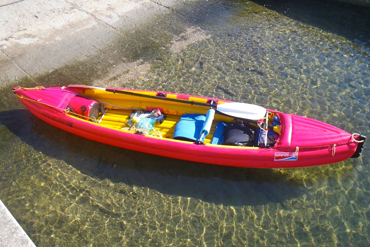
After more than 12 years my tandem Grabner H2 IK was showing signs of wear all over. The most visible appeared behind the fore half deck where two grommets fed the grab lines (below left). Around those grommets the rubber coating had worn off, showing the bare woven core material of the Hypalon fabric.
I knew Grabner could provide an MRO service as stated on their web site and the French Grabner reseller confirmed he could send my boat to the factory in Austria for a quotation. That came the week later in German, but what didn’t need translating was the substantial figure at the bottom which added up to something like “you’re better off buying a new boat”. Another major concern was a crack that developed under the aft backrest bracket (middle). This ill-designed bracket has a sharp edge that gets pushed into the skin under the weight of the paddler. After some years of chafing it had worn a small hole that proved difficult to patch reliably.
I must to admit the H2 is not as perfect and tough as I’d claimed so loudly. Encounters with various submerged obstacles and a number of uncontrolled landings had resulted in many scars and scratches all over the hull. I now also own a similar Incept K40 for solo paddles, but as I intended to keep the H2 as a tandem boat, I thought it was time to give it a serious makeover.
Grabner’s attitude to those requiring a more seaworthy kayak than an H2 was get an Explorer or the framed but now discontinued Discovery, but those IKs are way too bulky and heavy (26kg and 29kg respectively) for transportation when shuttling about.
My H2 weighs just 16kg. Plus they are just about the most expensive IKs in the inflatable world (left). I discussed the money issue with the other half of the H2’s crew who happens to also be the purser. She too wanted to keep the H2 and was not as appalled by the cost as I was, so after a short deliberation we decided to proceed. Three weeks later my local reseller informed me enthusiastically that my H2 was here and beautifully refurbished. Save for the numerous patches it looked like new.
The Grabner folks had done a great job; even the foredeck grommets had been neatly repaired.
All backrest brackets had been replaced with new parts of a much better design. A new pair had been added at my request to enable solo paddling from a central position. Up till then I’d sat in the back of my H2 when solo.
Most cockpit fittings like footrest and D-ring brackets which had started coming loose had been reglued.
There was a keel strip on the bottom as well. Surprisingly the Austrian guys hadn’t paid attention to the colour of the patches (left). While the inside the H2 is yellow, they applied patches in external red. I should have supplied them the yellow patches I’ve got in my repair kit. Anyway, I’m happy the boat is in such great shape again, if not better than before. I can’t claim it’s worth as much money as I’ve spent on it, but I’m sure my H2 will go for another 12 years.